Showing posts with label 20th Century. Show all posts

Sunday, 14 April 2013

The Destruction of the High Street in 1942


This is a follow-up to an earlier post, 'The Destruction of the High Street Before 1942', and a brief summary of the Exeter Blitz can be found here.

The photograph above from c1920 shows the view up the High Street looking east towards Sidwell Street. If nothing else it shows the wonderful architectural diversity of the pre-war High Street, the product of centuries of gradual evolution. The tower of St Lawrence's Church is about halfway up on the left. The entrance into St Martin's Lane is in the foreground on the right. Apart from the altered facades of No. 226 High Street and No. 227 High Street, and St Stephen's Church (whose weathervane can just be seen poking above the rooftops on the right), not one of the buildings shown in the photograph remains standing today.

Not all of the buildings shown in the image were destroyed in 1942. For example, the ornate stone bank on the corner of St Martin's Lane and the timber-framed house with oriel windows next to it (No. 37 High Street) were demolished in the 1950s. No. 229 High Street, just beyond the tram on the left, was demolished in 1930. But it does show the approximate extent of the wartime destruction of the High Street and a complete historical street scene which has disappeared forever.

Pevsner wrote that "the German bombers found Exeter primarily a medieval city, they left it primarily a Georgian and early-Victorian city. The close-knit pattern of medieval streets and alleys, medieval churches and houses is irretrievably gone". This perhaps needs some qualification. By the end of the 19th century, anyone wanting to experience a visual flavour of medieval Exeter beyond the Cathedral Close would've had to trek to the forgotten slums of the West Quarter, to Preston Street, Smythen Street, Frog Street and Stepcote Hill, to Paul Street, Mary Arches Street and parts of Catherine Street. By 1942 much of Exeter's surviving medieval fabric had already been swept away through slum clearances. The High Street itself had been one of the first parts of the city to experience modernisation in the 18th and 19th centuries. And on the surface at least, Exeter was far from being a medieval city.

But in a real sense Pevser was quite right. The fingerprints of the Middle Ages were still in evidence all across the city, primarily in its street plan, in the presence of the Castle, Cathedral and Guildhall, and in the survival of many of the medieval tenement plots, all of which were encircled by the majority of the medieval city walls. And there were almost certainly many medieval and early post medieval buildings hidden behind altered facades and embedded in later structures.

Unfortunately most of the individual tenement plots were eradicated between the post-war reconstruction of war-damaged areas and the various redevelopments of the 1960s and 1970s. During the same period much of the ancient street plan was either either rerouted or totally/partially obliterated e.g. George Street, Bampfylde Street, Milk Street, Goldsmith Street, Pancras Lane, Little Stile, Sun Street, Chapel Street, Guinea Street, Coombe Street, James Street, Catherine Street, Frog Street, Edmund Street, James Street, Musgrave Alley and King's Alley. Almost miraculously, the Castle, Cathedral and Guildhall still survive. Anyway, the High Street on the eve of World War Two was one of the most picturesque streets remaining within the boundary of the city wall, perhaps notable for its rich architectural variety than for any single building.

The Exeter Blitz began at around 1.50am in the early hours of 04 May 1942 and only lasted for about 80 minutes. 75 tonnes of bombs were dropped by 40 planes including 160 high explosives, parachute mines and around 10,000 incendiaries. The resulting fire was seen up to fifty miles away. By dawn 156 people had died, large parts of central Exeter lay in ruins and about 50% of the High Street, Exeter's foremost thoroughfare, had been irreparably destroyed.

. The image left shows the extent of war-damage in the High Street following the Exeter Blitz. It is based on a 1905 map of the city overlaid onto a modern aerial view of the same area. Only the section of the High Street affected by the air raid, around 50% of its total length, is shown.

The buildings on the tenement plots highlighted in red were nearly all completely destroyed down to ground level. Some had already been rebuilt prior to 1942 e.g. the Half Moon inn on the corner of the High Street and Bedford Street, but the High Street of 1905 was largely the same as the High Street of 1942. The late 19th century Post Office and Eastgate Arcade, which replaced St John's Hospital School, are to the right. A cross marks the site of the great medieval East Gate. The two most westerly pre-war buildings now surviving on the High Street are highlighted in purple: on the north side No. 229 High Street built in 1930, and on the south side St Stephen's Church. The image doesn't show the extensive network of courtyards, alleyways and smaller structures which existed at the back of the buildings fronting onto the High Street but which were also destroyed during the air raid. The gargantuan bulk of the Princesshay Shopping Centre which now squats on the site of Bedford Circus is easily visible to the south of the High Street. 

Drag the slider in the centre of the photographs below to see before and after images (or click on 'Show only then' or 'Show only now').


before
after

The photo above is from c1910 looking down the High Street towards the west. The brick entrance into the Eastgate Arcade is on the left. Slightly further down on the same side is the stone Gothic Revival facade of the main Post Office. The properties on the immediate right were built c1830 and marked the corner of the High Street with London Inn Square (now the site of 'Waterstones').

before
after

The photo above shows the High Street looking east towards Eastgate and, in the far distance, the start of Sidwell Street (now occupied by the tower block at Nos. 1 to 11 Sidwell Street). The Eastgate Arcade and Post Office are on the right. In the centre of the photo are the premises of The Cathedral Dairy Company (you can just see the lettering on the side of the wall). This was at Nos. 6 & 7 Eastgate, beyond the boundary of the city walls. The premises were converted out of the late 18th century residence of the headmaster of St John's Hospital School. The small, three storey timber-framed house on the left was No. 264 High Street. Before the start of the 20th century the date 1597 was written under the gable but by the 1930s this had changed to 1297! The late 16th century date is probably much more accurate. Unfortunately such externally ancient buildings were a rarity in the High Street by 1942. Next to No. 264 is a tall building with a gable end facing into the street, No. 265. This only dated to 1893 and replaced the much-earlier Apothecaries' Hall, formerly at No. 246 High Street.  Next door to No. 265 is the Georgian facade of Nos. 266 & 266 High Street, fashioned in the 1780s from stone recycled from the East Gate. Just about visible is a niche at first-floor level which contained the gatehouse's statue of Henry VII.
before
after

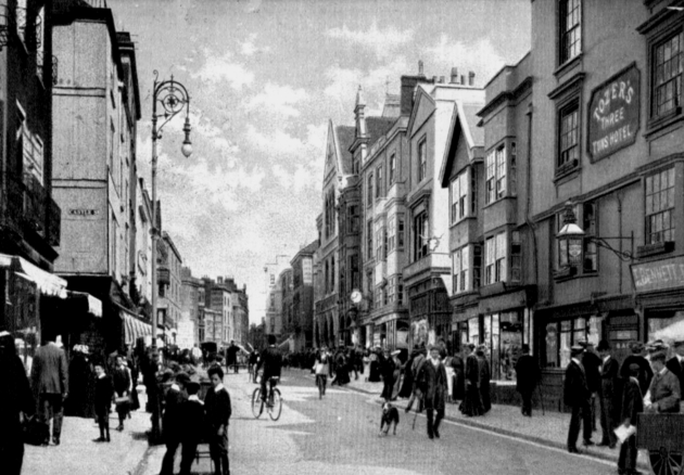
The photo above c1900 was taken looking in the same direction i.e. towards Eastgate. Electric trams had yet to be introduced into the High Street so the image dates to before 1905. If that dog was in the High Street today it would probably get run down by a minibus! The Post Office and Eastgate are still visible on the right. The entrance into Castle Street, which ran up to Rougemont Castle, is on the left. The entrance was much narrower before 1942 and was massively widened during the post-war reconstruction. The three-storey gabled house on the right, from c1600, stood at the High Street's junction with Bampfylde Street. Another very narrow street, Bampfylde Street was dominated at its far end by the magnificent Bampfylde House. To the far right is the Three Tuns inn at No. 8 High Street. In 1836, at the rear of the Three Tuns, workers unearthed a subterranean chamber described at the time as a "Roman sepulchral family vault". The chamber was 7ft square with an arched roof. Around the walls were niches containing five urns believed to contain the cremated remains of some of Exeter's Roman citizens. The inn closed in 1913 but the premises survived until they were destroyed in 1942.

before
after

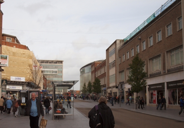
The photo above dates to c1930 also showing the view towards Eastgate. The south wall of St Lawrence's Church is on the left. The former Three Tuns building, now missing its first floor windows, is the fourth along on the right. Apart from St Lawrence's Church and the stone Post Office, nearly every other building shown was destroyed to ground level during the Exeter Blitz. This was almost certainly a consequence of most of them being constructed in the 18th century or earlier on timber frames with lath and plaster facades. Next to St Lawrence's is the arched entrance into the Empire cinema, Exeter's first, a not particularly attractive addition from 1911. Comparison between the 'then' and 'now' photos vividly shows how much this part of the High Street was widened during post-war reconstruction.
before
after

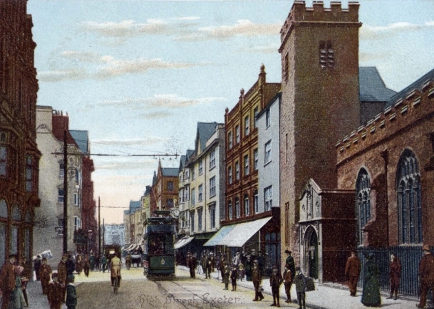
The photo above is taken from about the same place as the previous one but looking in the opposite direction c1910. St Lawrence's Church is on the right. Most of the building dated to the 15th century although the south wall, visible in the photo, was rebuilt in 1674. The stone for the porch was recycled from a late 16th century water conduit which stood close to the church until the conduit was demolished in 1694. The conduit was adorned with statues of Henry VIII and Elizabeth I. The statue of Elizabeth was placed above the porch when it was added to the church in the 1690s. Although the interior of the church was gutted in 1942 the south wall, medieval bell tower and porch survived the air raid only to be demolished during the post-war reconstruction. Running under the building to the immediate left of the church was a covered passageway which led, since 1692, to a small churchyard. Beatrix Cresswell described it in 1927: "Just beside the tower is the narrowest possible slip which surprises the enterprising wanderer by leading him into a tiny courtyard where there are two little houses, their porches overgrown with white jessamine, and a fat friendly cat offers a welcome." Cresswell thought it was "a delicious corner of the old city, with the red wall and cusped windows of the old church at one side of it". Unfortunately it was all destroyed in 1942. On the opposite side of the street can be seen the side wall of the Half Moon inn at the entrance into Bedford Street. By 1942 the Half Moon had been replaced with Deller's Cafe (see photo below).

before
after

The photo above c1930 shows the most attractive ensemble of buildings destroyed in the High Street in 1942. The sign for Deller's Cafe is on the far left although the main entrance was actually via Bedford Street. Most of Deller's exterior stonework and some of the ornate interiors survived 1942 but were demolished during the post-war reconstruction. Not visible in the photograph but a little further down on the same side was the site of the New inn at Nos. 25 & 26 High Street. The building still contained the 'Apollo' ceiling created by Thomas Lane between 1689 and 1690, destroyed in 1942. Most notable of the buildings on the right was Brufords at No. 241 High Street, a fine 17th century townhouse which once belonged to the Earls of Morley. Its most notable feature was a clock which projected over the pavement supported on the back of an enormous carved figure of Father Time. To the left of Brufords can just be seen part of the neo-Classical facade of the West of England Fire and Life Insurance Company at No. 237 High Street. The facade, built in 1833, was surmounted by a colossal statue of King Alfred, the Company's emblem. Although the rest of the company's buildings were gutted during the air raid the facade survived. It was subsequently demolished during the post-war reconstruction. The modern photograph of the same area shows the side wall of No. 229 High Street. This marks the extent of the wartime destruction, although No. 229 lost its gabled roof during the air raid. It's easy to see how the pre-war line of the street was pushed back during the reconstruction against the recommendation of the city's post-war town planner, Thomas Sharp. The mural has since been replaced with that of a smiling woman with a tower block in the background.  The exterior timber work of the two buildings on the far right was a relatively recent addition in 1942. Although the buildings were probably 18th century or earlier, the timber facades were applied c1920. Thomas Sharp would've hated their lack of authenticity but I think they made a very attractive addition to the High Street's general appearance.

The photo above (Courtesy of Devon County Council) shows the view down the High Street within hours of the Exeter Blitz. Smoke is curling up from the ruins. The photo must've been taken from the roof of the burnt out post office building. The post office's stone gable and downpipes can be seen to the immediate left. The crenellated tower of St Lawrence's Church can also be seen in the distance. The burnt out building in the centre of the image stood on the corner of the High Street with Castle Street.

The photo below shows part of the rebuilt High Street c1953, prior to the construction of the monolithic 'Bobby's' department store. The wide horizontal lines of the post-war buildings were a total break with the narrow vertical appearance of the pre-war streetscape. One reason for the widening was to allow for a dual-carrriageway to run through the middle of the street! Whatever were they thinking of.


Unfortunately the Exeter Blitz wasn't the end of the 20th century's effect on the High Street. Although 50% of the street was destroyed in 1942 around half survived without any damage. Between 1950 and 1980 the remaining 50% had been reduced again by half leaving just a small fragment to stagger on into the 21st century. The demolitions between 1950 and 1980 will be the subject of part three of this series of posts.

 Sources

Thursday, 21 March 2013

Demolition at Magdalen Street & Holloway Street

The extended demolition of the South Gate area between 1962 and 1977 marked one of the most destructive phases in Exeter's 20th century history. Hardly a single bomb was dropped here during World War II and it largely escaped the catastrophic slum clearances of the pre-war years. The photograph left shows late Regency houses being demolished in Magdalen Street in 1964 © Express & Echo.

At South Gate the destruction of nearly all the historical structures in the area was a result of the inner bypass, a post-war ring road that now carves its way from the top of Sidwell Street, past South Gate, through the West Quarter and on towards Cowick Street and Alphington Street on the opposite side of the river. The scale of the destruction was immense as literally hundreds of pre-war townhouses, shops, courtyards, tenements, gardens and warehouses were bulldozed out of existence and replaced with what is now a multi-lane carriageway.

The clearance at South Gate alone involved the removal of much of Magdalen Street, most of Holloway Street, the whole of Quay Lane, a few surviving buildings at the bottom of South Street, and a large section of Exeter's city wall that had stood since the end of the second century AD. The Edwardian Exe Bridge, Alphington Street and Cowick Street fared little better.

What made the destruction at South Gate particularly unfortunate was its historical importance to the development of the city and the architectural significance of some of its buildings. Following the Exeter Blitz of 1942 it remained one of the Exeter's last intact historical cityscapes and a large number of the buildings dated to the 17th, 18th and early 19th centuries. The photograph above shows the view into Magdalen Street from the bottom of South Street in 1960 © Express & Echo. Nearly all of the houses shown dated from between c1659 and c1720, some with later mid 19th century facades. The photograph below shows the same view today.

As with almost everywhere in Exeter, South Gate has a very long recorded history. Sometimes shortened simply to Southgate, the area was the name given to the junction of South Street, Holloway Street and Magdalen Street where they met outside the great South Gate, itself demolished in 1819. The earliest artifact ever found in the city was recovered at Magdalen Street: a 250,000 year-old flint hand axe. The top of Holloway Street was the site of a Roman legionary cremation cemetery in the 1st centry AD and the Roman road between Topsham and Exeter terminated here. Now a small, picturesque town some four miles from Exeter, Topsham was the Second Augustan Legion's supply base. This route still exists, divided into Topsham Road and Holloway Street. Used by thousands of people every day, it runs in a characteristically straight line between Exeter and Topsham.

Magdalen Street, another road that ended at the South Gate, may also be Roman in origin. The main Roman route from Exeter to Dorchester is known to have run through Heavitree, about a mile outside Exeter. This road probably led originally to the Roman city's East Gate but it's likely that it forked before reaching the city walls with a spur running along Magdalen Road, Magdalen Street and into Exeter at the South Gate. The fork in the road is still present where Heavitree Road splits at what is now Livery Dole.

The image above attempts to show how the Roman roads converged on Exeter in the 3rd century AD. The perimeter of the Roman city walls is highlighted in red. The Exeter-Topsham service road used by the Second Augustan Legion cAD60 is highlighted in orange. The main Roman road from Exeter to Dorchester, ending at the East Gate (2), is highlighted in purple. The spur that forked at what is now Livery Dole (3), which comprised Magdalen Road and Magdalen Street, and which terminated at the South Gate (1) is highlighted in yellow. Except where it was destroyed outside the South Gate in the 1960s and 1970s, and where Paris Street was rerouted following post-war reconstruction, the road plan has remained essentially unchanged.

The image left shows the exterior of the South Gate from Holloway Street in the early 19th century. Magdalen Street runs off to the right. Although the gatehouse was demolished in 1819 the three 17th century timber-framed buildings to the left survived until they were demolished in the 1960s. The narrow entrance into Quay Lane was down the side of the nearest of the three houses.

Another ancient route that led into the area outside the South Gate was Quay Lane, used for hundreds of years to bring goods up into the city from the Quay. Built over the city's in-filled defensive ditch, Quay Lane was lined with small houses that backed onto the city wall, the variety and charm of its townscape the product of centuries of gradual evolution. In c1300 the Greyfriars of Exeter moved their friary from its site at Bartholomew Street inside the city to a large area outside the city walls just south of Holloway Street. Dissolved during the Reformation, some of the friary buildings survived until they were demolished during the English Civil War. The houses on Quay Lane were built within the precinct of the old friary and two roads south of Holloway Street are still known today as Friars Walk and Friars Gate.

The South Gate itself formed one of the main entrances in and out of Exeter. In 1452 Henry VI began a Royal Progress that reached Exeter on 17 July. Accompanied by 300 dignitaries from the city, he was met at Livery Dole by the monks from the city's Greyfriars' priory and Dominican friary. The king and his entourage then processed along Magdalen Road, Magdalen Street and into the city at the monumental South Gate which had been adorned especially for the occasion. Braun and Hogenberg's 1587 map of Exeter above right shows that a small medieval suburb had built up outside the South Gate in Magdalen Street and Holloway Street. Nicholas Smith's mansion of Larkbeare is shown as is Quay Lane and what are probably some of the remaining buildings of the Franciscan friary in the field at the bottom.

In the autumn of 1645, during the English Civil War, the city's Royalist defenders deliberately razed around 80 houses on the south side of Exeter to clear the ground outside the South Gate and to have an improved field of view for cannon and muskets. Most of the houses outside the city walls in the South Gate area, including many in Magdalen Street and Holloway Street, were affected. In his book, 'Two Thousand Years in Exeter', published in 1960 before the 20th century demolition of the area began, Hoskins wrote that "there are a number of gabled houses of late seventeenth-century date in Magdalen Street and Holloway Street. These houses are those that were built again after the war was over to replace those that had been destroyed."

By the end of the 17th century many of the battle-scarred plots had new houses built upon them. One of these was a three-storey, brick-built mansion, constructed in Magdalen Street for Thomas Matthew in 1659. Another significant property was known as Magdalen House, built for Dr Michael Dicker in the first decades of the 18th century. There was also the Valiant Soldier, an inn rebuilt in 1651 which stood on the corner of Holloway Street and Magdalen Street and which was named after those who fought and died during the English Civil War, and the Red Lion inn, its courtyard and timber-framed walls sketched by John Gendell in the 1830s

Benjamin Donn's 1765 map of the city left clearly shows Magdalen Street, Holloway Street and Quay Lane as they converge at the South Gate. It also shows that by the mid 18th century the area had recovered from the damage inflicted during the English Civil War. The evocative drawing below © Exeter City Council by Richard Parker appears on an information panel associated with the site of the South Gate. The drawing shows the junction of South Street, Magdalen Street and Holloway Street c1800. Magdalen House, with a classical pediment at roof level, can be seen on the far right.

Exeter historian Jacqueline Warren left a vivid description of one small part of Magdalen Street prior to its demolition: "Another of these Jacobean houses had a cobbled passage to a court from which a flight of stone steps led to the front doors of two dwellings. This was Bowden's Place, and in its happy, simple design, it had incredible charm. Beyond the first court, and past a fine, early nineteenth century iron gate was another little courtyard where a hefty sandstone buttress held the lower portion of a slate-hung house. The narrow cob-wall passage of one of the houses led to an alley from which could be seen the slightly sagging ridges of original slate roofs. Eventually, through this enchanting maze, one coud reach Holloway Street". Following the pre-war slum clearances, the bomb damage of 1942 and the destructive post-war reconstruction, the post-English Civil War houses around Southgate were some of the oldest domestic buildings still standing in Exeter outside of the Cathedral Close.

The image left shows the 1905 Ordnance Survey map of Exeter overlaid onto an aerial view of the same area today with the following numbering: 1 Site of the South Gate, 2 Quay Lane, 3 Magdalen House, 4 42-46 Magdalen Street, 5 The Valiant Solider Inn, 6 Magdalen Street, 7 Holloway Street, 8 Nos. 71-73 Holloway Street, 9 Site of Franciscan Friary. The route of the city wall is highlighted in purple. The buildings destroyed as a direct consequence of the inner bypass, well over 200 in total, are highlighted in red. Quay Lane was completely demolished, even though the bypass ran nowhere near it, as was most of Magdalen Street. Holloway Street was similarly decimated.

The pre-war aerial view right shows Holloway Street in the foreground running up to the former site of the South Gate (marked with a red arrow) and merging almost without a break into South Street. It shows how densely built-up the area was at the beginning of the 20th century. The majority of the buildings north of the red arrow were destroyed in pre-war slum clearances or during World War Two. The majority of the buildings south of the red arrow were destroyed during the creation of the inner bypass.

The inner bypass was initiated as early as 1949. It was designed to intercept heavy traffic arriving at Exeter from the east and bypass it across the river. In 1950 work began on surveying the proposed route between the top of Sidwell Street and Exe Bridge. Construction didn't commence at Belmont Park near Sidwell Street until 1953 and by 1960 the bypass had reached as far as Magdalen Bridge. 1962 saw the demolition of the Valiant Soldier inn and work started on continuing the bypass from Holloway Street to Exe Bridge.  By 1965 the bypass was complete but work continued on creating a gyratory road system near to the old West of England Eye Infirmary. The last demolitions didn't take place at South Gate until 1977 by which time the road system achieved its present form.

The photograph above shows the view across the junction of Magdalen Street and Holloway Street in the 1940s. The three gabled houses to the right from c1680 are the same ones visible in the early 19th century depiction of the South Gate but with slightly altered facades. The very narrorw entrance into Quay Lane was to the left of the left-hand house.

In his book 'Conservation Today', published in 1989, David Pearce discusses the implementation of so-called Dangerous Structures Notices used by English city councils in the 1960s and 1970s to get rid of inconveniently sited old buildings: "Council-owned, council-neglected then council-condemned was all too frequently the fate of listed structures impeding redevelopment". The idea was that the local authority would purchase a building, willfully neglect it and then issue a DNS on the structure when it was deemed either structurally unsafe or unfit for habitation. As Pearce says, "Exeter swept away splendid seventeenth century merchants' houses as if vying with Bristol to disfigure itself". The photograph below © Express & Echo shows Magdalen Street in the early 1960s when demolition had started in Holloway Street (in the background). The Valiant Soldier inn had already been bulldozed.

Pearce continues: "A building does not need to be neglected for many years before grounds can be discovered for declaring it unsafe, or at the very least unfit for habitation. A classic case occurred in 1977 in Exeter where the city council condemned and destroyed seventeenth and eighteenth century listed houses in Magdalen Street, containing particularly rare plasterwork, which it had originally bought (and then neglected) in connection with what even the local newspaper called 'megolomaniac' traffic schemes". (Another property that suffered the same fate was Whipton Barton, a large 17th century farmhouse in Whipton village. The history of the site dated back to the Domesday survey. Whipton Barton was purchased by the city council in the 1950s, left to fall into disrepair and, despite being a listed building, was demolished in the early 1960s. A block of flats, known as Rennes House, was built on the site.)

The photograph above shows Nos. 42-46 Magdalen Street in 1975. Purchased by the city council they were allowed to rot before being demolished. The late Georgian facade of Nos. 44-46 concealed the mid 17th century brick mansion of John Matthew, a fact that was only discovered when the property was being demolished.

The specific buildings mentioned by David Pearce were Magdalen House and Nos. 42-46 Magdalen Street, all of which were Grade II listed structures. (Magdalen House was listed in 1953. Nos. 42-46 Magdalen Street were listed in 1974. They were all demolished just three years later.) It is shocking to realise that these particular buildings, on the north side of Magdalen Street, did not impede in any way the new road system. The current pavement is on the same alignment as it was before the creation of the inner bypass and where the houses once stood is just a big patch of grass in front of the modern Southgate hotel.

As Jacqueline Warren states, after 1974 Magdalen House "seemed safe, and it has never really been made clear why it was not properly looked after; why it was demolished instead of restored". Other important buildings suffered the same fate. No. 36 Holloway Street, known as Holloway House, was granted Grade II listed status in 1953. It was a large brick townhouse built at the end of the 17th century, its three-storey facade set back from the road. It was demolished in 1980. No. 35 Holloway Street dated to 1797 and was listed in 1973. It too was demolished. Nos. 48-56 Holloway Street were also Grade II listed in 1973. These were mid-19th century houses with stucco facades and an unusual string course and cornice that curved up the face of the houses following the slope on which the houses were built. These too were demolished. The west side of Holloway Street was almost completely obliterated. Nearly 400 metres of pre-war frontages were torn down leaving just three, traffic-blighted examples near the top to indicate what has been lost. (The three survivors on the west side are Nos. 71-73 Holloway Street, all Grade II listed, shown above and as 8 on the Ordnance Survey aerial view.) The east side fared little better with 'only' around 200 metres of pre-war frontages being demolished.

Not only were most of the affected buildings in Holloway Street and Magdalen Street destroyed without any archaeological or architectural record, but a 30 metre stretch of the Roman city wall was hacked down to ground level by council workmen using pickaxes. As a Scheduled Ancient Monument the city wall was allegedly protected by law but the council applied to the Ministry of Works for permission to demolish it and permission was granted (another large section was destroyed at Eastgate during the post-war reconstruction). The houses in Quay Lane, another area that had little to do with the creation of the inner bypass, were also destroyed. The photograph above shows the large section of the city wall that was demolished to accomodate the inner bypass, now spanned by a pedestrian footbridge. The photograph below shows the view towards the Magdalen Street-Holloway Street junction today.

Changes in legislation during the 1980s made it more difficult for local authorities to destroy listed buildings but, for Exeter at least, it was too late as the obliteration of most of the city's historical fabric was complete. The pre-war slum clearances in Paul Street, Frog Street, Smythen Street, Preston Street and Stepcote Hill, the bombing in 1942 of the High Street, South Street, Bedford Circus and Sidwell Street, the post-war removal of most of the standing structures in the bomb-affected areas, the creation of the post-war inner ring road, the installation of the flood defence system in the 1960s, the rebuilding of the Exe Bridges at Cowick Street and Exe Island, and the creation of the sprawling Guildhall Shopping Centre at North Street, Goldsmith Street and Waterbeer Street has resulted in the wholesale destruction of Exeter as a visually historic city.

The loss of life caused by the Exeter Blitz shouldn't be forgotten but it seems strange that so much emphasis is placed on the physical damage wrought upon the city by German bombers in 1942 when the majority of the architectural losses over the course of the 20th century have been entirely self-inflicted.

Even some of those buildings which now survive, feted as important parts of the city's architectural heritage, only escaped through the post-war endeavors of protestors. For example, in the 1960s and 1970s the city council actively campaigned for the total demolition of the Higher Market in Queen Street, the late Regency houses in Bartholomew West, and the 16th and 17th century houses at No. 226 and No. 227 High Street. (The Higher Market was partially demolished anyway and Nos. 226 and 227 only exist today as shallow facades, their ground floors completely gutted.)

In the city's Royal Albert Memorial Museum is a display of medieval, Tudor and Jacobean metal door fittings that were salvaged from the ashes of buildings destroyed in 1942. These fittings are accompanied by an information panel that makes the bizarre assertion that "after so much destruction people were determined to look after the historic buildings that remained".

There are of course instances of the post-war city council salvaging historical buildings e.g. the remaining fragment of old Larkbeare House further down Holloway Street, the much-publicised 'House That Moved' (moved to the edge of the inner bypass) or, more recently, the restoration of Cricklepit Mill, but the extent of the demolition that took place around Exeter following World War Two is quite at odds with the museum's bold claim. It was only exceptional conservation cases that were considered to be of any importance. Although the general background noise of lesser streets and perhaps lesser buildings provided context, coherence and visual proof of organic development over centuries it was, unfortunately, regarded as expendable.

Two other issues deserve mention. One is Exeter's over-burdened road system. The inner bypass was completed in the 1970s when both car ownership and the population of the city were much lower. I'm sure it was lovely to speed around the semi-empty new road system in the early 1970s but anyone who has queued along Alphington Road, Topsham Road, Holloway Street, Western Way, Magdalen Street or Cowick Street will understand that the inner bypass now suffers from major gridlock at key times of the day. The situation will only become worse given the thousands of new houses that are being thrown up around the city's outskirts. It seems all that demolition only provided a temporary solution to what is becoming an increasingly big problem.

The other issue is the poor architecture that was built in the South Gate area following the creation of the road system. These squat blocks of flats have no redeeming features other than their lack of verticality (although at least if you're in it you don't have to look at it.) Like so much of Exeter's post-war architecture, they wouldn't appear out of place on an industrial estate. What was once the great historical approach into the city is today a barren wasteland of roads, junctions, roundabouts and traffic lights.

Sources

Sunday, 11 December 2011

Nos. 61, 62 & 63, High Street

The current building on the site left only dates to 1976 and occupies what was once three separate plots: Nos. 61, 62 and 63. It sits in a prominent location on the corner of the High Street with Broadgate, the ancient ceremonial entrance way into the Cathedral Close and the site of the largest and most ornate of the Close's medieval gatehouses. (The Broad Gate itself was demolished between 1824 and 1825.)

The city council's conservation report from 2002 describes No. 63 as "a rebuild of a listed building demolished in 1976". The report continues: "Stretching across three historic frontages, it is built from pale stone with the windows being simple, rectangular dark brown single panes of glass. A three storey oriel window on the corner and a similar window close to the junction with No. 60 provide some interest".

Unfortunately I don't know much about the listed building which was demolished in the 1970s. I don't know when it was listed or why it was listed, and this section of the High Street seems to have been one of the least photographed areas of the city centre! The conservation report mentions "three curved bays at ground floor level reflecting the earlier plot widths" which can be seen on the High Street facade of the current building. They conveniently divide the High Street frontage into thirds.

The image right is a detail from an aerial view of the city c1930. It shows the previous building on the site, highlighted in red. Its most distinctive feature was probably a two storey oriel corner window on top of which was a squat lead dome. The facade was made of brick alternating with bands of stone with a stone parapet running across the top. Clearly the facade was all built at the same time and, from the street at least, there was little sign of the three older plots mentioned in the conservation report.

But hidden behind the parapet can be seen three hipped roofs of quite different sizes. I think it's probable that Nos. 61, 62 and 63 were indeed three completely separate buildings and that sometime around the end of the 19th century their frontages were all replaced with the brick and stone facade shown in the photograph leaving the older cores remaining intact behind. This happened throughout Exeter on a number of buildings and it's one reason why the fabric of the city was in fact much older than it often appears in pre-war photographs (Nos. 17 & 18 North Street are classic examples). This might well account for why the buildings had received listed status prior to their demolition in 1976.

The listed buildings were badly affected by fire in the mid-1970s. Photographs taken of the rear of the buildings after the fire showed that the houses were of a relatively light-weight timber-framed construction. To me this suggests a date of between 1660 and 1700 which would be in keeping with other Exeter houses built in the same period which are of a similar construction. (In July 1778, in the cellar of a house belonging to Mr Upham "situated in the High Street at Exeter, at the corner of Broad-gate" workmen uncovered five superbly cast little bronze statues of Roman gods. Upham's house was probably either at No. 63 or at what is now Nos. 65 & 67 on the opposite corner of Broadgate, although No. 197 on the other side of the High Street has also been suggested.)

Unfortunately no other investigation of the ruins was possible and the remains were demolished without further record. The fire-damaged structures were removed and the replacement building now stands on the site. As a piece of Modernist in-fill it is admittedly very successful. It retains a sense of scale which relates well to the surrounding properties and it has hardly dated at all. The subtle oriel windows are an attractive feature which break up the monotony of the plain facade, and the chamfered corner and the pale stone mirror the early-20th century Neo-Classical bank at Nos. 65 & 67 on the opposite corner. It is preferable to the repellent 1960s in-fill building at Nos. 50 to 52 or anything in the recent redeveloped Princesshay area.

The postcard above left from c1910 shows the view up the pre-war High Street with the now-demolished building at Nos. 61, 62 and 63 highlighted in red. The densely-packed housing and varied street frontages continued in a remarkable, almost unbroken line from this point up to the end of Sidwell Street well over a kilometre away. Unfortunately the vast majority of it has since been destroyed through wartime bombing and post-war demolition. The photograph below shows the entrance into Broadgate to the right with the High Street stretching away to the left.

Sources

Friday, 2 December 2011

No. 59 & 60, High Street

No. 59 on the High Street left only dates to c1925. It is a peculiar last gasp of 19th century Neo-Classicism carried over into the 1920s and infused with sporadic Art Deco details. It was built as a bank, is still used as a bank and the building it replaced was also a bank!

For much of the 19th century No. 59 was the premises of the Exeter branch of the National Provisional Bank. I only know the most rudimentary details about the building which was replaced c1925 but it was spread over four floors. There were at least two arched entrances, with rusticated keystones, above which ran a cornice on brackets, an arrangement which was not dissimilar to the one which exists today.

The windows on the upper floors were surrounded by simple architraves. A string course running across the facade visually separated each floor. It probably dated to the first half of the 19th century. The building was damaged by smoke and water during a serious fire in 1881 which destroyed all of the properties between the bank and No. 54 but it was repaired afterwards and continued in use for over forty years. The building was expanded between 1911 and 1912 and No. 60, High Street, to the right of No. 59, was demolished to create the extension. During the demolition of No. 60 some interesting discoveries were made.

A series of medieval walls were uncovered within the property itself which were believed to relate to the security wall erected around the Cathedral Close at the end of the 13th century. (Part of this wall is apparently still visible in the cellars of Nos. 41 & 42 further up the High Street.) Underneath these walls, approximately 11ft beneath the level of the High Street itself, two other walls were uncovered. Aileen Henderson Fox, the archaeologist who excavated much of Roman Exeter after the Blitz of 1942, surmised that these two walls were probably Roman in origin and could possibly have been the remnants of a Romano-Celtic temple.

Also discovered in one of the rooms during the demolition were some sections of a 16th century wall painting executed in a typically Renaissance style above right © Devon County Council. Part of it contained an inscription including the name of the Tudor monarch "Elizabeth R". The remains of the painting were fortunately photographed but the medieval and Roman walls, the painting itself and anything else of historical interest were all destroyed during the rebuilding.

For whatever reason, the old bank building and the extension at No. 60 were replaced in the 1920s with the structure which still stands in the High Street today. It is four bays wide, the outer two bays projecting into the High Street, and three storeys high. The ground floor is clad with rusticated grey marble blocks. Two arched windows are framed by two arched entrances, each having protruding keystones. Above each entrance is a scroll pediment. On the corners of the projecting outer bays are square pilasters of white Portland stone with exaggerated entasis and Ionic capitals. All of the first floor windows have round pediments beneath which are lintels with Art Deco-style keystones left. Swags of fruit hang between the first and second floor windows and a deep, bracketed cornice runs along the roof line.

It's not the most exciting building in Exeter and fares poorly when compared with the more successful Neo-Classical bank at Nos. 65 & 67 which was built just twenty years earlier. But the decorative details are of a fairly high quality and the slightly cluttered impression of the facade is at least distinctive. Perhaps surprisingly, No. 59 isn't a listed building but it is probably distinguished enough to warrant a place on the national register eventually.

Sources

Wednesday, 2 November 2011

No. 53, High Street: Tudor Revival

Dating to the early 20th century, this interesting and attractive building is a relatively late example of the Black-and-White Revival style of architecture more commonly associated with historic cities like Chester. It was built c1905 and replaced an earlier 18th century facade closely related in appearance to the still-standing building at No. 54. It's possible that evidence of the earlier building still survives inside.

At first glance the black and white facade of No. 53 looks relatively plain, constructed on four floors, two bays wide with a large gable overlooking the street. But closer examination reveals a multitude of fascinating details. The architect clearly looked to the Gothic splendour of Exeter Cathedral as his inspiration. In a cusped niche between the windows on the second floor is a large wooden statue of Leofric, the first Bishop of Exeter below right, and the date 1050, the year in which Leofric was enthroned at Exeter as bishop in the presence of Edward the Confessor. The statue clutches a small model of the Norman cathedral in his left hand. The ecclesiastical theme is continued in the small shields on the third floor, one of which depicts the crossed keys of St Peter against a sword, the heraldic symbol of the Bishops of Exeter below left. Both of the shields are surrounded by intricately carved panels. High up on the top of the gable is a large finial similar to the Gothic ballflower pinnacles of the Cathedral itself. Even some of the black timbers form the outline of cusped Gothic arches against a white background.

Between the windows at first floor level is a leaded stained glass window depicting the coat of arms of Exeter, a three-towered castle flanked by pegasus supporters.

Where the second floor jetties out over the first floor it is supported by four brackets carved with imps and devils. The third-floor oriel window is also supported by four carved brackets, each depicting a human head in medieval costume. A frieze, deeply carved with foliage, runs above the oriel window across the entire facade of the building.

Even the bargeboards of the gable end are elaborately carved, and for once the modern shopfront is a tasteful addition in keeping with the rest of the property. The references to Exeter's ecclesiastical past make No. 53 a unique building, fully deserving of its Grade II listed status. It is unfortunate that its impact on the overall street scene is marred by the grim presence of the 1960s rebuilding of Nos. 50-52 to its immediate left.

No. 53 also provides an interesting 'What If?' scenario concerning the sad fate of the city following the devatastion of World War Two. According to Thomas Sharp, the planner behind much of the city's post-war reconstruction, one possible option for rebuilding lay in what he dismissively referred to as "medieval trappings".

In his 1946 publication 'Exeter Phoenix', Sharp wrote that "many citizens" in the city envisaged Exeter rebuilt in the style of Chester, which still has the most notable collection of Black-and-White Revival architecture in England. Sharp specifically stated that "the example of Chester is often quoted" and continued: "the blitzed sites of shops display brightly-coloured designs for the 'medieval' facades which will mask the selling of draperies and the dispensing of afternoon tea...Exeter has so long regarded itself as 'medieval' that it is almost inevitable that it can only think of itself in 'medieval' dress". Sharp, perhaps disingenuously, stated that the reconstruction of Exeter in a Tudor Revival style was not only "likely" but "quite certain, unless some policy to the contrary is laid down". In reality there was very little prospect of the city being reconstructed in such a fashion in 1950s Britain.

Such a reconstruction was anathema to Sharp. Rebuilding Exeter along the architectural lines of Chester would, he believed, have been "lamentable" and could only produce "meaningless and incongruous" effects which would look "contemptible...To attempt to rebuild 20th century Exeter with medieval forms would be the work of a generation that is visually blind and spiritually half-dead".

It is the greatest irony that the post-war buildings which eventually arose across the bomb-damaged city were of such pitiful quality, of such meagre architectural value that they are now being pulled down, demolished and rebuilt (although it should be added that their 21st century replacements are hardly a great improvement). No. 53 survives today as an indication of what at least parts of the damaged city might've looked like if the local authority had indeed opted for a historically-informed reconstruction of Exeter. As architectural historian Gavin Stamp wrote in 2007: "Would Exeter really have been any worse had it been rebuilt in the fake-medieval manner that Thomas Sharp so feared? The Cathedral remains glorious, but the city is certainly no longer a jewel."

Sources

Wednesday, 28 September 2011

Nos. 65 & 67, High Street

As it stands today Nos. 65 & 67 is one of the most impressive examples of neo-Classical architecture in the city. Like Nos. 70 & 71 on the High Street, Nos. 65 & 67 partly owes its current appearance to the major redevelopment which took place between 1903 and 1905 in the vicinity of St Petrock's church.

The history of the adjacent church is both long and interesting but by at least the beginning of the 19th century it was almost totally enveloped by houses. Jenkins, in 1806, wrote that "scarce any part of it can be seen except the tower" and the Rev. George Oliver recorded in 1828 that the church was "buried in the midst of houses". The church was only accessible from the High Street via a passageway which led underneath one of the houses. At the beginning of the 20th century it was decided to sweep all of the surrounding buildings away, both widening the High Street and revealing the north face of the church for the first time in centuries. (Hooker's map of Exeter suggests that the church was already surrounded with houses by the late-1500s.)

Nos. 65 & 67 is the result of a merger in 1901 between two of Exeter's oldest banks: the Exeter Bank, founded in 1768 and the City Bank, founded in 1786. These two banks then merged in 1902 with a London bank, Prescott, Dimsdale & Co, followed by yet another merger in 1903 with the Union of London & Smiths bank. (This bank was later to become part of National Provincial whose name partly lives on as the National Westminster bank.) The mergers from 1901 to 1903 were commemorated in a large plaque which still exists on the High Street facade of Nos. 65 & 67, right. The City Bank already owned premises in Cathedral Yard but it was decided to erect another building adjacent to it for the Exeter Bank, and this is the building which now sits on the corner of the High Street with Broadgate.

The construction of the new building in 1905 coincided with the plans to demolish the properties surrounding St Petrock's church. Instead of building on the exact footprint of the property which previously occupied the site, the line of the High Street frontage was moved back towards the Cathedral Yard. A photograph in the Westcountry Studies Library dated 1905 shows the bank under construction at the same time as Nos. 70 & 71, on the other side of the church, were being demolished. Clearly there was some synchronisation between the clearance of old properties around the church and the construction of the new bank.

Unfortunately little is known about the buildings that the Exeter Bank replaced. I've never seen a photograph of them. One small but fascinating piece of information has survived though concerning what was No. 65. It seems that this building had groin vaulted undercrofts, the only such example that has ever been recorded in one of Exeter's domestic houses. Jenkins mentions the undercrofts in his 1806 history of the city: "Near the Church, under the house now occupied by Mr George Cox, is a cellar; which, from its arched stone groins, has occasioned conjectures, that it was originally the crypt of an ancient chapel." These undercrofts were destroyed during the construction of the bank and the reason behind their existence will forever remain a mystery.

The bank that arose on the site was constructed of beautiful Bath stone. It is three storeys high with a rusticated ground floor. The High Street facade is five bays wide, each bay separated at first and second floor level by pilasters topped with Corinthian capitals. The Broadgate facade is two bays wide, divided again with pilasters. A chamfered corner from the High Street into Broadgate contains the main entrance.

The corner facade is just one bay wide , the windows framed with more pilasters and Corinthian capitals. All of the first floor windows have pointed pediments and balustrading and a deep modillion cornice runs under the eaves. The ground floor windows have round arches inset into which are quarter Tuscan columns. Above the main entrance is a stone parapet supported by enormous corbels decorated with stylised acanthus leaves and within the arch over the entrance is a decorative panel inscribed with the words 'Exeter Bank'. Crowning the corner of the building is a large buttressed cupola with a copper roof.

When you actually stop to look at it Nos. 65 & 67 is a magnificent building, although I don't believe that the cupola is a particularly effective addition. To construct the same building today would cost a fortune. It was granted Grade II listed status in November 1971 and is currently used as retail space.

Sources
Related Posts Plugin for WordPress, Blogger...