Showing posts with label Guildhall Shopping Centre. Show all posts

Friday, 9 March 2012

St Pancras Church & Pancras Lane

The small church dedicated to St Pancras is a remarkable survival. Narrowly escaping demolition, it now stands within the 1970s' Guildhall Shopping Centre, stripped of all its historical context and "incongruously dished up on a platter of municipal planting in the middle of a paved square" (Pevsner and Cherry). The medieval street plan which surrounded the church until the mid-20th century suggested an ancient origin but this has unfortunately been swept away. The foundation itself though is ancient, as is much of the still-standing building, and it's possible that St Pancras church occupies the earliest site of Christian worship in Exeter. There has been some speculation that the church was founded by the Romano-British Christian citizens of Isca Dumnoniorum, the Roman town which evolved out of the Second Augustan Legion's fortress in the first century AD.

Christianity had been imported into the British Isles centuries before St Augustine founded the Diocese of Canterbury in 597. The church at Exeter's patron saint was probably St Pancras of Rome, a 14-year-old martyr who was allegedly killed on the orders of the Emperor Diocletian in Rome c304 AD and who was one of the first martyrs to be venerated by the early Christian church. Unfortunately, apart from some bits of Roman tessellated pavement excavated from around the church, there is little actual evidence to support the claim of a Roman foundation. The theory seems to rest on an early 19th century tradition that the Roman praetorium stood in the vicinity. Jenkins repeats the tradition in his 1806 history of the city and it had been repeated by numerous commentators ever since. The Roman pavements were probably installed in the corridors of private houses.

The church is referred to in 1191 but it's highly likely that the foundation is pre-Conquest in origin even if it doesn't date back to the Romans. There is some evidence that the remains of a Saxon doorway were found embedded in the south wall of the chancel during restoration in the 19th century. The Anglo-Saxons did have a number of churches in Exeter, including St George, St Martin, St Olave and a monastery in what is now the cathedral precinct. St Pancras was almost certainly another, very early foundation.

For over a thousand years the church stood on a narrow street called Pancras Lane. A detail from Hedgeland's early 19th century model of Exeter above right gives a good idea of the medieval layout of the church and surrounding street plan. It remained little altered from the Middle Ages until the middle of the 20th century. The church is highlighted in purple. The now-vanished buildings which fronted onto Pancras Lane are highlighted in red. The street had a very noticeable dog leg in it, even more exaggerated than a similar one formerly in Mary Arches Street. Quirks in an old street plan are always interesting. Maybe there was a Saxon enclosure around which the street was forced to make a detour, as is believed to have been the case at Mary Arches Street. Either way, the church probably predated Pancras Lane itself.

Pancras Lane connected Paul Street with Waterbeer Street. Another route off Pancras Lane was Trichay Street. Until 1349 it was possible to walk from Pancras Lane down Trichay Street and into North Street. Although blocked up in the 14th century by the rectory for St Kerrian's church, Trichay Street survived as a route until the 1970s. It's interesting to compare the image above left with the Hedgeland model. It shows a detail from the 1905 map of Exeter overlaid onto a modern aerial photograph of the Guildhall Shopping Centre. St Pancras church is highlighted again in purple. Pancras Lane is shown running past the church from Waterbeer Street and exiting into Paul Street at the top. The building plots highlighted in red have all disappeared since 1905. The photograph also shows the vast expanse of flat roofs and car parks of the Guildhall Shopping Centre which now covers much of this part of Exeter.

The photograph right © Exeter City Council shows a rare view looking down Pancras Lane towards Paul Street c1937. The photograph indicates that even in the 1930s the street still retained its built-up character with properties lining both sides of the narrow thoroughfare. The buildings might've been different but this had been the character of the street since the Middle Ages. The covered passageway visible to the left of the car led into Arthur's Buildings, a courtyard with properties on either side.

Most of the buildings on Pancras Lane were deliberately removed between c1937 and 1951 as part of the city's council's planned redevelopment of the area behind the Higher Market. This left most of the ancient street as little more than a large car park. The alignment of the street had already been altered when the police station on Waterbeer Street was constructed in 1887. The new police station also resulted in the demolition of several houses to the north-east of the church which, until then, had been "hidden from public view by the gradual accumulation of squalid tenements around it". The area was left unscathed by the Exeter Blitz but the church was threatened with demolition in the 1960s. Fortunately it was spared, and although the surroundings are now bland and mediocre the church itself is of genuine interest.

The plan is very simple, consisting of just a nave and a chancel with no aisles or porches or towers. The layout and the extremely small dimensions have been compared with the Anglo-Saxon church at Escomb in County Durham. Although the oldest parts of St Pancras date to the 13th century, the ground plan could well have remained unchanged since Saxon times. The walls have been patched over the centuries and the church today is largely constructed from blocks of purple volcanic trap with scattered blocks of sandstone, red Heavitree breccia and white-veined volcanic trap from Pocombe. This gives the church a quite different appearance to most of Exeter's surviving parish churches, many of which were rebuilt in the 15th century from red Heavitree breccia with dressed sandstone around the windows and doorways.

A number of descriptions of the church state that it's built from friable red Heavitree breccia but close examination of the walls show that this is clearly untrue. It seems likely that the church was rebuilt or overhauled in the 13th century. A two-light lancet window with Y tracery above left and a one-light lancet window, both in the north wall of the chancel, date to the 1200s. A three-light (restored) east window, also with distinctive Y tracery, is of a similar date. The insides of the chancel windows have round-headed rere-arches. These are some of the oldest surviving windows in any of Exeter's parish churches.

The three windows in the nave are of the mullion type and were probably installed in the 16th century although the nave itself also dates to the 1200s. The exterior of the west wall has a relieving arch embedded in it made of purple volcanic trap. I wonder if there was once a western bell tower here with an internal opening into the nave.

The 1587 Braun and Hogenburg map of Exeter shows St Pancras church. No tower is visible but there are two windows set into the west wall so perhaps the relieving arch took a single large window.

Inside the chancel is a piscina right, used for washing the communion vessels. It has a three-foiled cusped arch and also dates to the 13th century. It features a shallow bowl carved in the shape of a quatrefoil. Above it is a strange little niche. Cresswell believed it might've been an aumbry, used for storing chalices and other vessels, but it does seem a bit small. Maybe it was used to hold a small reliquary or the sacramental bread. The oldest visible feature in the church today is the 12th century circular font with a band of bead moulding around the top below left. According to Cresswell, the font was damaged by over-zealous restorers in 1831 who "scraped it until all traces of antiquity were well nigh scraped away". Compared with other Norman fonts in Devon, such as the superb example at Stoke Canon near Exeter, it does seem rather plain but it is also perhaps the oldest font in the city. (A more elaborately carved Norman font also survives at the church of St Mary Steps.) There's no reason to doubt that the font has been on the same site since the 12th century.

In 1658, during Cromwell's Commonwealth, the church was sold to its parishioners for £50. The parish register for St Pancras also records an earthquake which shook all the houses in Exeter on 19 July 1727: "It was felt all over England, and in some places beyond the sea". Jenkins described the church in 1806, stating that it "bears evident marks of great antiquity" and adding that "it is a very small and plain building, forty-six six inches in length, and sixteen feet in breadth.

The interior is dark and gloomy, consisting of a Nave and Chancel, the latter only is seated; the pulpit and font are very old. As no use is now made of this Church, excepting as a Cemetery for a few families, it is consequently very much neglected, and may soon be desecrated". The church wasn't desecrated but was partially restored in the 1830s. The church reopened in 1830 "having been disused for a number of years". The 'Exeter Flying Post' believed it hadn't been used "either wholly or partially since the execution of "Archbishop Laud"! Certainly untrue, but it does appear that the church was badly neglected throughout much of the 18th century. A 19th century sketch shows the church with a gaping hole in the chancel roof and smashed glass in the 13th century windows.
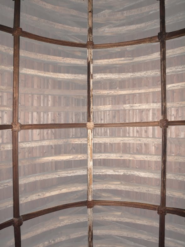
The roof of the nave right, although restored, dates to the 15th century. It has a barrel vault, a type also found at St Mary Steps, St Mary Arches (roof destroyed in 1942), St Lawrence (destroyed in 1942), St Olave (sadly hidden beneath a later roof), at St Martin and at Tucker's Hall in Fore Street (probably the finest of all).

The entire roof structure is now visible at St Pancras but in the 15th century the spaces between the ribs would've been covered in plaster. I've recreated the effect of the plaster panels to give a better idea of the roof's medieval appearance. Carved wooden bosses, once brightly painted, cover the points where the ribs meet. The church received a major restoration between 1887 and 1889, having been closed again for 12 years.

The work was carried out under the supervision of John Pearson, the Gothic Revival architect of Truro Cathedral and the partially reconstructed cloisters at Exeter Cathedral. For once, the Victorian 'restoration' was relatively sympathetic and didn't involve the complete reconstruction of the entire building. The chancel was in a particularly advanced state of decay and was rebuilt stone for stone, reincorporating much of the original fabric and all of the surviving 13th century features, such as the windows and the piscina (although unfortunately not the remains of the Saxon doorway). The chancel roof was rotten, having been left open to the elements for part of the 19th century, and so Pearson replaced it entirely with a wagon roof similar to the surviving 15th century roof in the nave.

The stonework of the 13th century east window was consolidated. Pearson believed that the east window was an insertion added into a pre-existing wall. Three carved fragments with Romanesque decoration were discovered in the walls of the chancel. These have now been inserted into the south wall of the chancel but they are so badly damaged that it's difficult to see them as anything more than ragged bits of stone. They appear to have been part of a corbel table, but whether they were originally belonged to the church itself or were recycled from another building in the city is unknown.

The photograph left shows the view inside the church looking east towards the chancel. It's clear to see how the apex of the nave roof and the apex of the chancel roof don't line up. Both parts of the church are built on a slightly different alignment suggesting two distinct phases of construction. The pulpit, just visible to the left, dates to c1600 and came from the church of Allhallows on Goldsmith Street when it was demolished in 1906. Pearson's one major error was in building a new chancel arch resting on corbels and using Bath stone, a material completely at odds with the rest of the church. Pevsner and Cherry called it "unsympathetic", and so it is. The arch had already been replaced with brick in the 1830s. Following Pearson's restoration, the church reopened on 02 June 1889. The lesson was read by the Archdeacon of Exeter and the Bishop of Exeter preached the sermon.

The church contains a few other interesting features. Pearson's work involved stripping all of the plaster from the walls. This action uncovered the arched doorway of the rood stair right, probably added in the 14th century. Built into the thickness of the wall was a stone staircase leading via an internal doorway at first-floor level to the rood loft above the rood screen (the screen, separating the nave from the chancel, was apparently removed c1800).

A few of these steps still remain in situ and the blocked up doorway of the rood loft can be seen as a scar high up on the north wall. The rood loft provided access to the top of the screen so that the great rood, an effigy of the crucified Christ, could be cleaned or decorated, or so that candles could be lit. The church had a number of floor slabs, the earliest of which dated to 1669 and commemorated the burial of Benjamin Board, one of the city's merchants. Unfortunately these slabs are now presumably covered by the modern flooring. The few wall memorials all came from Allhallows on Goldsmith Street. One of them records the death of Loveday, the daughter of Christopher Bellett. She died of smallpox in 1711. Four of her sisters died from the same illness in February and March 1717.

The photograph left shows the interior of the church looking towards the west wall. The church also has a single medieval bell hanging in a bell turret above the western wall. It was cast during the 15th century by the Exeter bellfounder, Robert Norton. It is inscribed, in Latin, with the motto: "I may be small but I am heard over a great distance". I've lived in Exeter for nearly 40 years and I've never heard it ring once.

The other particularly lovely addition is the fine late 19th century stained glass inserted into the east window below. It shows St Pancras of Rome, with Christ in the centre and St Boniface to the right. St Boniface is believed to have studied at a Saxon monastery in Exeter and the site of the monastery was thought to be close to St Pancras' church. (In reality the site of the monastery is almost certainly near the west front of the cathedral. The remains of the Saxon minster there were only excavated in the early 1970s.) The stained glass in the east window was the gift of Bishop Tozer, the first Bishop of Zanzibar. Beautifully executed, I don't think it would look out of place in one of the side chapels of the cathedral.

St Pancras church is well worth visiting for anyone who is in Exeter and hasn't yet been inside. As Hugh Meller says in his book 'Exeter Architecture': "St Pancras has survived. Miraculously it retains an atmosphere of tranquillity which most other central Exeter parish churches have lost and it serves as a constant reproach against the arid post-war development in Exeter represented by the Precinct that surrounds it".

Sources

Sunday, 4 March 2012

A Brief History of Waterbeer Street

Waterbeer Street, left c1905, is one of the oldest streets in Exeter. It runs parallel with the High Street, joining North Street to what was once Goldsmith Street. There is evidence that it formed part of the Roman civitas, possibly dating to the very early years of the town's formation between c70AD and 80AD. A large number of Roman finds, especially coins, have been unearthed in the street over the last two hundred years as well as several large fragments of tessellated pavements.

The modern name of the street is mentioned as early as 1253 when it appears on a deed as 'Waterberestrete' and again in 1327 as 'Waterber Strete'. According to most commentators the name is occupational, like Goldsmith Street, Preston Street, Smythen Street and Milk Street, and probably means 'the street of the water bearers'. Clean water was a valuable commodity in the Middle Ages and many people would've relied upon water sourced from wells and springs within the city walls. Fresh water wasn't piped into the city through the underground passages until c1200, and even then it was initially only for the use of the cathedral clergy and, from 1226, the monks at St Nicholas's Priory.

For citizens without access to a private well the water sellers would've walked the streets of Exeter selling water from jugs carried on their back. If they congregated or lived in Waterbeer Street then that would explain the origins of the name. An alternative theory was suggested by Robert Dymond at the end of the 19th century. Dymond thought the name could refer to the ecclesiastical office of the 'bearer of Holy Water' although I think this is far-fetched. The image right shows part of the 1587 Braun and Hogenburg map of Exeter. The houses on Waterbeer Street are highlighted in red.

Exeter's first purpose-built theatre opened on Waterbeer Street on 30 December 1734, although plays had been performed in the city since the Middle Ages (e.g. the mayor and chamber are known to have attended a play at the Dominican Friary near Bedford Street in 1409.) The new theatre is named on Donn's 1765 map of Exeter and appears to have been set back from the street and accessed through a passageway between properties on Waterbeer Street itself. It was located on the same site as the big flower bed now opposite the back of the Guildhall.

Baring-Gould tells a story that following a visit to the city by the Methodist preacher, John Wesley, in 1743 "the local comedians were prosecuted as vagrants and forced to give up their theatre in Waterbeer Street". The temporary closure of the theatre was probably the result of issues relating to the Licensing Act of 1737. Either way, the Methodists appear to have rented the building temporarily, using it as a chapel until the actors resumed occupation. The theatre continued in use until 1787. The presence of the theatre led to Waterbeer Street being called Theatre Lane until the theatre closed, at which point the street reverted back to its old name.

The image left shows a detail from Caleb Hedgeland's early 19th century model of Exeter now in the city museum. All of the houses which fronted onto Waterbeer Street are highlighted in red. St Kerrian's church on North Street, rendered and whitewashed and with a little bell turret on the roof, is visible at the bottom. The bulk of the Guildhall is visible at the top, the rear part of the hall set back from Waterbeer Street itself.

One particularly intriguing building is described by Jenkins in 1806: "In Waterbeer-street...lately stood a very ancient building; it originally consisted of three semicircular arches, supporting an angular front, with an arched window in the centre: those arches or gateways led into a spacious hall, which (according to tradition) was the Praetorium or town-hall; while some respectable antiquarians judge it to be the remains of a religious edifice". The praetorium was a sort of governor's house found in cities and towns across the Roman Empire which could also function as a court house. The building on Waterbeer Street was also believed to be the architectural forerunner of Exeter's Guildhall, which has been on the High Street since at least 1160. It was probably neither the Saxon/early-Norman Guildhall or the Romans' Praetorium so what exactly was it?

Two depictions of this building survive. One was drawn by Jenkins himself and shows the southern gable end, above right. The other appears on Hedgeland's model left, shown as a hall-like structure with two arched windows in the north wall. Jenkins dismissed the idea of the structure being a church as there were "no remains of a vaulted roof" or any of those "grotesque embellishments so common in the religious edifices of our Saxon ancestors". According to Jenkins, the 18th century antiquarian Andrew Ducarel supported the theory that the building had a religious function and was "the first stone building erected in this city". This was also almost certainly incorrect too. The building was demolished in 1803, being "of a very ruinous state", and replaced with Kingdon's iron foundry. (Later known as Garton & King, foundry buildings of some sort remained on the site until they were demolished in 1963.)

Some parts of the building were exposed during the demolition. Jenkins recorded that "the back part appeared to be designed for a prison, under which were strong stone walls, surrounding a square vault, (in which were a privy and sewer) probably a dungeon." Several Roman coins were discovered and a silver groat from the reign of Henry VIII. Unfortunately nothing else is known about the building. It was presumably genuinely ancient and the round arches mentioned by Jenkins could've placed the building in the 11th or 12th centuries. It's true date and function will probably remain a mystery. Jenkins also describes "a large ancient roomy house", which was attached to the mystery building, and which was used as a boys' charity school.

Much of the north side of the street was widened between 1876 and 1905 resulting in the loss of most the older properties on that side. One major late Victorian development was the construction of a new police headquarters complete with cells and courts left. In 1887 houses on Waterbeer Street and in Pancras Lane were demolished to provide a site for the new buildings. The police station was sited almost opposite the rear entrance of the Guildhall, the same location occupied by the theatre 150 years earlier. As the foundations were being dug three large fragments of tessellated pavement decorted with a geometric design were unearthed about 2ft below the surface level. The fragments were lifted and relaid in the foyer of the police station along with a plan showing where they had been found.

Aileen Fox thought that this pavement was the same one recorded by the antiquarian William Stukeley in 1723, described by him as "a great Roman pavement of little white square stones". The pavement was probably a corridor mosaic installed in the private house of a Roman citizen. The new police station was an attractive structure in its own right. Constructed from red brick with dressed stone windows and door surrounds, its most distinctive feature was a large turret with a tall conical tile-hung roof which projected out from the corner of the building at the junction between Waterbeer Street and Pancras Lane. The turret had three tall traceried windows with a series of quatrefoils running beneath the roof line. The building cost £5000. Peter Thursby's 1977 bronze sculpture 'Looking Forward' right marks the site of the police station today.

Until the post-war period the south side of the street still contained an almost unbroken line of historically interesting buildings, most of which were timber-framed and dated to c1700 or earlier. Those which survive include: No. 14, now the Devon Camera Centre. Dating to the 17th century it has a hipped gable roof and a 19th century shop front. Nos. 15 and 16 is a three storey red-brick warehouse from c1800. Next to this is the rear of the Guildhall. This part of the Guildhall dates to 1838 and was built as a replacement for two cells used as a female prison since 1558. On the first floor is a jury room lined with 17th century panelling taken from St Katherine's Priory at Polsloe. Adajcent to the back of the Guildhall is what was formerly the rear of the Turk's Head on the High Street. Then there are Nos. 17a, 18 and 19. Each has a gable of a different size and it's likely that the core of these buildings are much older than the facades suggest. All of the buildings are Grade II listed and are shown in the photograph below.

The street's late 19th century appearance remained little changed until the post-war period. This part of the city, including most of North Street, Waterbeer Street, Pancras Lane, Goldsmith Street, Queen Street and Paul Street survived the Exeter Blitz of 1942 completely unscathed. The Waterbeer Street police headquarters closed in 1959 when the city police moved to new premises in Heavitree. (The new police building was on the site of William Hooper's Higher Summerlands, a row of 11 large red-brick townhouses from c1804. All but one of these fine houses was damaged or destroyed in 1942 and the sole survivor was demolished in the 1950s). The police station and court rooms in Waterbeer Street was demolished soon afterwards. The Roman tessellated pavement in the foyer was lifted again and transferred to the Royal Albert Memorial Museum where it was erroneously identified as a fake by one of the curators and subsequently destroyed.

As mentioned above, the foundry was demolished in 1963 and between 1972 and 1976, many of the remaining buildings on Waterbeer Street was bulldozed to create the Guildhall Shopping Centre.

The image right shows a detail from the 1905 map of Exeter overlaid onto a modern aerial view of the same area. Nearly all of the plots highlighted in red were demolished between 1960 and 1976 and none of them survive today leaving just a quarter of the pre-war street intact. All of the standing buildings on the north side, most of which were Victorian, were demolished and over half of the south side was also demolished.

This included the loss of at least four buildings of some antiquity. No. 21 Waterbeer Street was a Grade II listed property built on four floors. Cased in brick it was of timber-framed construction and probably dated to c1700 or earlier. The south end of the building fronted onto the High Street as No. 198 High Street. No. 21 Waterbeer Street was granted listed status in 1974 but was demolished soon after.

To the right of No. 21 was No. 22 Waterbeer Street. It too was timber-framed with a hipped gable roof and also dated to c1700 or earlier. This formed part of No. 197 High Street. The Ordnance Survey map of 1951 shows that both No. 197 and No. 198 were two long medieval burgage plots probably created in the 15th century by the subdivision of a larger single tenement plot. Hoskins wrote about these two properties in his 1960 book 'Two Thousand Years in Exeter'. They were both part of a quirk in the parish boundary line of St Martin's church which saw the parish boundary leap across the High Street to include Nos. 197 and 198 High Street. According to Hoskins, the tenement plots of Nos. 197 and 198 High Street, "both of which extend back into Waterbeer Street" and which were "two adjoining properties", had been "in St Martin's parish for nearly 750 years". Like its neighbour at No. 21, No. 22 Waterbeer Street was demolished.

No. 23 Waterbeer Street was also built on four floors with a slate gable roof. It had a stucco facade inset into which were Georgian sash windows. It too dated to c1700 or earlier and was associated with the same burgage plot on which stood the remnants of the late 16th century townhouse at No. 196 High Street. No. 196 High Street was demolished, along with Nos. 21, 22 and 23 Waterbeer Street partly to create a pedestrianised entrance into the shopping precinct from the High Street. The building at the back of No 195 High Street which also contained 16th century elements was demolished at the same time.

The photograph above shows the north side of Waterbeer Street today. The police station stood to the far right of the image, beyond the end of the red brick wall. Another building razed to the ground c1974 was No. 20 Waterbeer Street, an attractive two storey brick-faced property with a stone string course dating to c1800, possibly hiding an older core. Snell's Buildings, a small terrace of 10 little houses at a right angle to Waterbeer Street and accessed through a covered passageway were also destroyed. The former New Market Inn on the corner of Goldsmith Street and Waterbeer Street dating to c1800 or earlier was another casualty, along with nearly every building on Goldsmith Street itself.

Bizarrely, these buildings were all destroyed without any archaeological record being made so it's now almost impossible to say exactly what was lost. Only 25% of the Waterbeer Street buildings shown on the 1951 Ordnance Survey map of Exeter still survive today. The photograph right shows the view into Waterbeer Street from its junction with North Street.

It's an ugly story, particularly in light of the destruction already wrought on other parts of the city by the slum clearances and the 1942 air-raid. Even uglier was the red-brick expanse of the shopping centre which took the place of the demolished buildings. In the words of Pevsner and Cherry, the precinct is "a crushing disappointment" full of "banal commercial building" in which the surviving medieval church of St Pancras makes "a pathetic and inappropriate centrepiece" now "deprived of its homely and historic setting of small streets". But compared with the shopping centre's impact on North Street and Paul Street, described as both "disastrous" and "catastrophic", the area around St Pancras church and in Waterbeer Street seems positively Arcadian.

There is little reminder today that Waterbeer Street was even once a separate street in its own right. The impression now is of a small group of surviving historical properties staring out onto an open public space tacked onto which is a pedestrian passageway with completely modern commercial structures on either side. The city council's own 2002 conservation report included the rebuilt Nos. 21, 22 and 23 Waterbeer Street and the whole of the Guildhall Shopping Centre as some of the buildings which "make a negative contribution" to the area but nearly 40 years later and the entire precinct now seems relatively subtle in comparison to the overbearing redevelopment of Princesshay.

Sources

Wednesday, 7 September 2011

Medieval Merchants at No. 36, North Street

Until the early 1970s North Street was the location of two of Exeter's most important medieval domestic houses, both frequently cited by architectural historians in various periodicals and academic papers. One was No. 38, North Street. The other was No. 36, North Street.

Both houses shared a similar layout and were of a similar age. Both still retained significant remains of their late-15th century origins, including their arch-braced hall roofs, and both were demolished by the city council to build the Guildhall Shopping Centre.

Derek Portman surveyed the building in the early 1960s for his book 'Exeter Houses: 1400-1700' and much of the following information is derived from his account. (Incidentally, Portman wrote detailed reports of about 33 separate buildings in the city which he regarded as the most significant examples of their period. Over 11 of these buildings have since been demolished.)

Stretching back from North Street by approximately 140ft, No. 36 had been added to and altered throughout its nearly 500-year existence but the medieval plan and much of the early fabric remained intact. Like most of Exeter's medieval domestic housing, it was built on a long but narrow strip of land called a burgage plot. The original accommodation probably consisted of a shop, a solar, an open hall, a parlour, a large (bed) chamber, a kitchen and another chamber, and the arrangement of these rooms within the house was of great interest.

The shop with the solar above were built as a single, two-storey block fronting onto North Street. Immediately behind this, and at right angles to the street in order to squeeze it onto the narrow plot, was the hall, open to the roof. Behind this was another two-storey block containing the parlour with a large chamber above. Behind that was a courtyard and behind that was yet another block containing the kitchen with a further room above. Running underneath most of the medieval property was a cellar lined with the red Heavitree breccia used so frequently in Exeter. A through-passage ran down the entire south side of the building giving entry into all of the ground floor rooms and linking the entrance from North Street with the courtyard at the back. The first-floor chamber above the parlour was linked with the chamber above the kitchen via a gallery that sailed out across the courtyard. All of the exterior side walls were built of Heavitree stone and the others were timber-framed. According to Portman, this unusual plan is "repeated, with minor differences, in only one other surviving house in the city, No. 38 North Street".

Whoever built the house in the late-15th century was a citizen, probably a merchant, of significant wealth. Inevitable changes had taken place. The ground floor had been lowered by about 2ft. At the same time the timber-framed facade had been replaced and brought forward by 2ft. According to Portman it was still possible to see traces in the north wall of the jettied first floor as it oversailed North Street. The once open hall had also been divided into two rooms by the insertion of a floor. The kitchen block had been extended c1600 with the addition of two rooms behind it, and in the 1750s yet more accommodation was added behind the kitchen with the construction of another two-storey block containing a drawing room.

The photograph at the top of this post © University of Exeter shows the view towards North Street from a narrow alleyway that ran along the north wall between No. 36 and No. 35. To the right is the gabled end of No. 35, built in the latter-half of the 16th century, with a timber-framed extension at the rear. (No. 35 was demolished at the same time as No. 36.) To the left is No. 36, its open hall, and the window from which it was lit, clearly visible. The map right shows the position and extent of No. 36 c1900.

So what exactly remained of the medieval building at the time of its demolition. The side walls were all intact. The through-passage also remained as well as the cellar. Three chimney-stacks still stood in the north wall. There was a huge, 6ft-wide fireplace from the open hall with a corbelled hood made from purple volcanic trap and moulded jambs with a similar, smaller fireplace in the parlour. A "great splayed window" in the north wall also survived from the hall with smaller windows that once probably lit the staircase. Only part of another fireplace remained in the first-floor solar but, writes Portman, "the one in the principal chamber is well preserved". Also preserved was a section of the wood and plaster partition between the parlour and the hall. Most of the timber-frame and stone walling of the kitchen block also remained, both from the 1400s and the 1500s along with another large fireplace. The first-floor of the kitchen block contained more wood and plaster partitioning as well as its simple late-medieval roof. Panelling and a carved chimney-piece remained in the mid-18th century drawing room.

But "the most imposing feature in the whole building" was the arch-braced roof of the open hall. Three bays spanned the open hall and another two bays spanned the chamber above the parlour, much of which was "still intact". The arch-braces supported the main rafters, making "a continuous arch from wall to wall". Purlins ran parallel with the side walls and between the purlins were wind-braces, the upper set being inverted. Over 22ft high, the open hall had been the physical and social centre of the building and most of the woodwork would've been viewable from the ground floor. A very similar, slightly finer roof existed at No. 38 North Street. (Another similar roof was at the 'Norman House' in Preston Street. Damaged in 1942, the building was totally demolished during the subsequent post-war reconstruction.)

There is little else to add that hasn't already been said in previous posts regarding North Street. Even in the early 1960s No. 36 was empty and in a "dilapidated condition". Despite the rarity of their medieval layout and their importance to Exeter's by then greatly-diminished stock of historically important buildings, No. 36 along with its near twin at No. 38 were both demolished in the early 1970s to build the visually atrocious Guildhall Shopping Centre. It seems incredible that two almost adjacent medieval open halls with intact arch-braced roofs should've simply been torn down as late as the 1970s. No. 36 stood to the right, near the footbridge, in the photograph below.

Sources

Saturday, 13 August 2011

The Demolition of Goldsmith Street

Goldsmith Street escaped the bombs of 1942 but failed to survive the attention of Exeter City Council in the 1970s, a period that saw almost the entire street swept away in the name of redevelopment.

The photograph left © Devon County Council shows a rain-washed Goldsmith Street in the early 1930s. The view is towards the High Street from Paul Street (Webber's, a late-18th century building that was demolished in 1962 is just visible in the distance on the High Street, standing where Burger King is today).

On the immediate left is the late-17th century St Paul's church. Its main entrance was through an arched doorway directly off Goldsmith Street (near the woman with the umbrella). Further up on the same side is the enormous neo-Classical facade of the Higher Market, accessed via steps with wrought-iron hand-railings. On the right are the facades of numerous shops and buildings, an almost continuous line of street frontages broken only by the narrow entrance into Waterbeer Street further towards the High Street. Apart from two buildings (No. 3 & No. 4 Goldsmith Street) and the central portico of the Higher Market facade itself, every single building shown has since been deliberately demolished and a 1000-year-old street wiped off the map.

Wind the clock back over a millennium and people were walking along the route of Goldsmith Street in the 8th and 9th centuries as it was one of the streets laid down in the city by the Anglo-Saxons.

Gandy Street and wrecked Catherine Street are two other examples of Exeter's Saxon street plan. And before that Goldsmith Street was the site of barracks for the Imperial Roman Army when a fortress was established at Exeter in the mid-first century AD. From around the time of the Conquest in the 11th century until the construction of the Higher Market in the 1830s, Goldsmith Street's most distinctive features were probably the two small churches which stood sentinel at either end.

The medieval foundation of Allhallows was sited at the entrance into the High Street until it was demolished in 1906. St Paul's church was on the corner of Goldsmith Street with Paul Street from at least 1066 until its reprehensible demolition in 1936. The drawing above right shows the view into Paul Street from Goldsmith Street c1830. The tower of St Paul's church is easily visible. The buildings to the right of the church tower were to be demolished a few years later for the creation of the Higher Market. The twin-gabled property near to the tower and almost hidden by a pent roof was probably Flaye's Almshouses.

The street had been known for the number of goldsmiths' workshops since at least the 13th century. A document from 1291 names the church of Allhallows as the 'Ecclesia omnium sanctorum in Aurifabria' i.e. the church of All Saints where the gold-makers work.

Apart from the two churches, there were at least two other buildings of known historical significance in Goldsmith Street prior to the construction of the Higher Market. One was Flaye's Almshouses situated adjacent to St Paul's church. The almshouses were founded and endowed in 1634 by one-time mayor of Exeter Thomas Flaye. His widow, Elizabeth Flaye, continued the endowment in her will of 1667. The almshouses in Goldsmith Street appear to have consisted of a large two-storey building with twin gables and an arched entrance which was subdivided into four separate dwellings for the use of four poor widows. According to Jenkins, writing in 1806, over the arched entrance way were "the Founder's arms, impaled with those of his Wife, with an inscription alluding to the foundation; over them is a winged hourglass, with other emblems of mortality; and the date of their erection carved on a stone table; over the inner entrance is another inscription." The drawing above left © Devon County Council dates to c1827 and shows a high-status timber-framed merchant's house probably dating to the early 1600s which stood in Goldsmith Street, probably opposite the entrance into Waterbeer Street. It was perhaps one of the properties demolished in the widening of the street in the 1880s.

The image right shows a detail from Caleb Hedgeland's early-19th century model of Exeter. The houses which fronted onto Goldsmith Street are highlighted in red and the two churches are highlighted in purple with Allhallows to the top left and St Paul's to the bottom right. The rear of the barn-like 15th century hall of the Guildhall itself can be seen in the centre at the top.

A parliamentary report of 1834 refers to "a banqueting house and house of office" situated behind Flaye's Almshouses. It's possible that this banqueting house was the other building of particular interest in Goldsmith Street: the Tailors' Hall. Jenkins recorded that the guildhall of the Company of Tailors was adjacent to the almshouses and "consisted of a convenient Dwelling-house, with a handsome Hall, for their meetings". The Company of Tailors had been granted the use of the hall and the house by Jane Tuckfield, the widow of another of Exeter's mayors, John Tuckfield, in her will of 1568. According to Peter Thomas, the Exeter Company of Goldsmiths and Silversmiths had their inaugural meeting in the tailors' hall on 01 August 1701. (Exeter was one of only seven English cities that had its own hallmark for use on all silver and gold which had been assayed in the city. The assay office in Exeter was created in 1701 and introduced Exeter's own hallmark of a triple-towered castle. Since the 1570s the city had been using its own town mark of a capital 'X' surmounted by a crown).

One of Exeter's most talented goldsmiths was Richard Hilliard. He was the father of the prodigiously talented Nicholas Hilliard, goldsmith, jeweller and painter of the celebrated miniatures which depict the Tudor court of Elizabeth I. Richard Hilliard held the office of High Sheriff of Exeter in 1560 and was married to a daughter of John Wall, another goldsmith to whom he was apprenticed, and it was perhaps inevitable that his son was influenced by the intricate craftsmanship which he saw being executed in his father's workshop. The exact location of Richard Hilliard's workshop isn't known but it's possible that it was in Goldsmith Street, although there is evidence that Richard Hilliard lived in the parish of St George in the West Quarter. One of Hilliard senior's most accomplished surviving pieces is a communion cup made for St Sidwell's church in Sidwell Street around 1572. This very fine cup is manufactured from silver with delicate engraving around the gilt-edged rim and foot. It is currently displayed at the Royal Albert Memorial Museum in the city left. It's remarkable that this cup should've been made in Exeter by Richard Hilliard while his son was in London painting the portrait of Elizabeth I.

The almshouses and the tailors' hall were both demolished in the 1830s when the magnificent Higher Market was constructed. The 230ft (70m) neo-Classical frontage towered over the narrow street which would've still retained much of its medieval character. Entry into the market from Goldsmith Street was through a giant columned portico capped with a pediment. The floor of the interior of the market building was significantly higher than the street level outside necessitating the construction of a flight of steps to give access from Goldsmith Street. But the creation of the market also created its own problems.

Throughout the 19th century the street retained its narrow width and increased traffic from the Higher Market saw numerous carts and horse-drawn waggons trying to enter the street from both Paul Street, the High Street and Waterbeer Street. Another image from the early 1930s is shown above © Devon County Council. The Higher Market is to the right, the tower of St Paul's is just visible in the distance. The suggestion of a jettied first floor on the two properties to the far left suggests that they probably dated to c1600. The street remained unchanged until it was demolished in the 1970s. In 1852, a Mr Parish from Maddock's Row at the back of Paul Street "put back two feet the frontage of two houses situated opposite the market steps" in return for £26 paid to him by the Commissioners for Improvement. But the real catalyst for change seems to have been the death of 11-year-old Fanny Solomon, accidentally killed in an incident involving a falling ladder and a waggon in July 1871. The coroner reported that the "narrowness of Goldsmith Street, where there was considerable traffic" was a contributory factor and suggested that measures be taken to remedy the situation in order to "prevent a similar deplorable occurrence".

It was decided to widen Goldsmith Street by removing all of the properties between the corner of the High Street and the Higher Market itself. But it was a slow process. In 1875 Trewman's 'Exeter Flying Post' reported that the Commissioners had been in contact with the freehold owners of houses on the east side of Goldsmith Street and, "with one exception, they had found all ready to sell either the whole of the property or sufficient frontage to enable the scheme to be carried out." The great sticking point was the church of Allhallows itself. Despite being constantly threatened with demolition throughout the 19th century, the Dean and Chapter rejected plans for the church's removal, much to the annoyance of the city council.

Eventually, in the mid-1880s, all of the buildings between the church and the Higher Market, approximately 190ft (58m) of street frontage, were removed. Allhallows church clung on until it was eventually demolished in 1906. The demolition of St Paul's church followed in 1936. New buildings were constructed to replace those which had been demolished during the widening of the road. These included the fine neo-Classical facades of the Wool Hall and the Phoenix Inn. The properties rebuilt after the 1880s road-widening are shown to the right in the photograph above © Devon County Council. Apart from the loss of its two churches Goldsmith street remained almost untouched from then until the early 1970s. In the late-1960s plans were unveiled by Exeter City Council for a new shopping centre, plans which involved the removal of the street. And not just the removal of most of the street's buildings, some of which dated to the 1600s, but for the eradication of the street itself. Between 1971 and 1979 Goldsmith Street was practically bulldozed out of existence. Thomas Sharp's post-war plan for the area in 'Exeter Pheoenix' show that he envisaged the demolition of many of the buildings on the street anyway, except for the Higher Market and those properties rebuilt in the 1880s, with Goldsmith Street itself widened until it was not dissimilar to Queen Street in scale. This was then supposed to lead via a pedestrian subway under the High Street into the Cathedral Yard itself. The scheme was never implemented as Sharp foresaw but the buildings were demolished all the same.

The image right shows a detail from the 1905 map of Exeter overlaid onto a modern aerial view of the same area. The High Street entrance into Goldsmith Street is to the bottom right. Buildings demolished since 1905 are highlighted in red. Apart from the two churches at either end of the street, nearly all of the demolition occurred between 1971 and 1979. Only part of the Higher Market and Nos. 3 & 4 remain today, highlighted in purple.

The majority of the Higher Market's Goldsmith Street facade was demolished, irreparably defacing one of the finest 19th century market buildings in the west of England. The ground level outside its remaining entrance was raised, burying the base of the columns and destroying the careful proportions of what was left of George Dymond's original design. Apart from No. 3 and No. 4 Goldsmith Street, all the buildings on the side opposite the market were also destroyed, a number of which had been granted Grade II listed status and which, taken as a whole, accounted for one of the few areas of the city which still retained its pre-war atmosphere. There was No. 1 Goldsmith Street, a late-18th century building spread over four floors with pilasters at either side of the facade stretching from the first floor to the parapet at roof level. Despite being granted Grade II listed status in 1974 it was demolished in 1979. No. 13 Goldsmith Street was another listed building, 17th century in origin with an 18th century facade. Formerly the Bull Inn, it too was demolished. The neo-Classical facades of the Wool Hall and the Phoenix Inn were salvaged. Re-erected in a different position the modified Wool Hall facade now forms the entrance into Marks and Spencer. The relocated Phoenix Inn facade below left arches over the service entrance into the same building, minus the reclining figures which once lounged in the spandrels of the arch.

On a profound level the heritage of the city was simply obliterated: many of the destroyed properties in Goldsmith Street still respected the narrow burgage plots of their medieval predecessors. The remains of Roman buildings were discovered underneath 14th century pot shards.

The thousand-year-old entrance from Paul Street was built over with modern retail space (now WH Smith). None of the properties opposite the market were rebuilt, the result being an open public area with more retail space cutting the course of the street in half. Nearly 1000ft (300m) of pre-war street frontage was demolished and today only a quarter of the original course of the street remains, on which stands just two surviving pre-war buildings.

This was nothing to do with slum clearances or the Baedeker Blitz of 1942, or the immediate post-war reconstruction or of the construction of the inner bypass, or of the flood prevention scheme, all of which had already destroyed vast tracts of the city. As Gavin Stamp quite rightly claimed: "despite all the cruel losses of the Blitz, Exeter was still prepared to sweep away distinctive and interesting old buildings". Put into the context of the destruction which had preceded it, the decision to demolish Goldsmith Street so comprehensively is unfathomable and unforgivable. Had it been renewed with imaginative restoration of its buildings then the street would've been as popular with independent retailers and as characterful as Gandy Street is today.

As Peter Thomas states in his book 'Aspects of Exeter', Goldsmith Street is now just "a mere stump linking High Street to a pedestrian square":

Sources

Thursday, 14 July 2011

Nos. 206 & 207, High Street

Attractive though they are, the facades of these two buildings are totally fake, cast out of concrete in the 1970s, modified versions of the original frontages.

Still, the reproductions were apparently good enough to fool the city council's own recent conservation report which stated that Nos. 206 and 207 "retain their attractive early 19th century facades", before adding that "they have been totally gutted as part of the Guildhall Shopping Centre development." They weren't just gutted. They were both razed to the ground, despite the fact that both buildings were granted Grade II listed status in 1974. Just five years later, in 1979, the two 150-year-old properties were totally demolished by the city council. Presumably moulds were taken of the facades prior to demolition. Concrete replicas were then cast and inserted onto the fronts of the new constructions.

No. 206, shown to the left in the photograph at the top of this post, dated to the early 19th century. The original listing description suggested that the rendered front possibly concealed an older building but obviously none of this earlier structure remains today. The post-1979 facade differs markedly from the original. As it stands today the structure is on three floors with vermiculated quoins extending from ground level to the modillion cornice at the top, above which is a non-continuous balustraded parapet. On the first floor, above the modern shop front, are two 12-light pedimented sash windows with two slightly smaller 12-light plain sash windows on the second floor.

Before its demolition No. 206 actually spread over four floors. An entire floor was lost during the reconstruction, necessitating a reconfiguration of the layout of the facade. The two pedimented sash windows were still present in the original but were less tall, having only 8 lights each. The major element, now missing entirely, were five arched windows at first-floor level, each window separated by slim Doric columns above which was a dentile entablature. The photograph right dates to the 1960s and shows the five arched windows on the first floor of No. 206, the pedimented sash windows just visible above. The modillion cornice and the balustraded parapet were all part of the original, early-19th century facade but the current facade is a pale imitation of its predecessor, not helped by the dirty and stained appearance of the concrete from which it was cast.

Standing on the corner of the High Street and the much-mauled Goldsmith Street, No. 207 High Street hasn't fared much better (shown to the right in the photograph at the top of this post). The original building was slightly later than its neighbour, No. 206, and seems to have dated to the mid-19th century although stylistically both buildings were very similar, sharing the same modillion cornice and balustraded parapet. The facade that now looks onto the High Street is an almost exact replica of the original, the first floor dominated by a large Venetian window with a plain curved pediment inset with foliage details. Each window is separated by square columns topped with bulls eye rosettes. The second floor has two sash windows with decorated architraves.

The corner of the building is chamfered as it turns left, probably designed to ease the passage of horses and carts into what was for centuries the very narrow thoroughfare of Goldsmith Street (nearly all of which was also demolished in the late-1970s). The architrave around the first-floor window inset into the chamfer is a post-1979 addition although the second-floor sash window with decorated architrave is consistent with the original. The Goldsmith Street facade is now very different. Before 1979 the facade was at least one bay longer with both a large twin sash window under a curved pediment and another Venetian window, similar in design to the one that appears on the High Street facade. Only the Venetian window was replicated in the reconstruction, moved from its original position to nearer the corner with the High Street.

The replicated facades, even in their inaccurate and scruffy condition, are preferable to the majority of the architecture in the High Street, so it's diffcult to be too critical. In a rare exception, the local authority made an effort to retain some semblance of Exeter's architectural heritage but the modified facades are now without any historical context, the buildings to which they once belonged having been destroyed. Both buildings are still on the national register of listed buildings but they should be removed.

An interesting postscript comes in the form of a late-18th century painting (detail right) that depicts this section of Exeter's High Street and which shows which buildings existed on the site prior to the construction of Nos. 206 and 207 in the early-to-mid 19th century, highlighted in red. The Guildhall is visible to the left. It appears that at least part of the site of No. 206 was occupied by a large red-brick property. If No. 206 concealed some older fabric prior to its demolition in 1979 then it would've been part of this structure. Next to it is the site of No. 207, which was occupied in the 18th century by a timber-framed building from the late 1500s or early 1600s. (Incidentally, the tall, four-storey, gabled and timber-framed building to the far right is the same building that once stood directly in front of the church of Allhallows in Goldsmith Street until the end of the 19th century.)

The postcard view of the High Street below dates to c1900 and shows Nos. 206 and 207 to the right of the Guildhall. Apart from the Guildhall itself and the Turk's Head inn just visible to the far left, all of the buildings shown on this side of the High Street have since been demolished.

Sources

Sunday, 6 March 2011

Nos. 22, 23 & 24, North Street

The site of Nos. 22, 23 and 24 in North Street is now under the multi-storey Mary Arches Street car park. Built in the 1970s, the construction of the car park, planned in the 1960s, resulted in the complete demolition of all of the buildings on the corner of North Street and Bartholomew Street East. Most of the buildings that were destroyed only dated to the late 1800s, when much of the west side of North Street was demolished in order to widen the road, although Nos. 22, 23 and 24 had a slightly different fate, even if the end result was the same.

On 02 July 1862 a report appeared in Trewman's 'Exeter Flying Post' under the title "Fall of a House in North Street". "Local archaeologists", the article beings, "will learn with regret that one of the oldest houses in North Street, the once, no doubt, splendid residence of some of the wealthiest of those old citizens, whose portraits now adorn the walls of Exeter Guildhall, has just fallen down before, what they will perhaps consider, the sacrilegious hand of modern improvement." What makes the demolition of this ancient building of particular interest is that its destruction was the result of accident rather than design.

Since at least the 15th century until the 18th century, North Street had been one of the most salubrious residential areas within the city walls, lined with the townhouses of some of Exeter's richest citizens. It appears that Nos. 22, 23 and 24 actually comprised a single vast house that had been subdivided into separate tenements with shop fronts facing onto North Street. A similar situation existed at Nos. 19 and 20, just one house away on the same side of the street, where a colossal early-17th century, timber-frame mansion was divided into two houses. (In fact the same thing happened to most of Exeter's medieval and post-medieval timber-frame buildings that had survived into the 19th century, especially in South Street, Paul Street, Preston Street, Smythen Street and Stepcote Hill.)

According to the report, Nos. 22, 23 and 24 once fomed a "handsome structure" that dated back to the 1560s having had "400 years [of] uninterrupted existence." The report contains a brief description of the building: "It is built in the light airy style of the day with bow windows, ornamented with scroll work, apparently carved in oak", and then goes on to describe the process by which it had been converted into tenements: "In the course of its 400 years, however, this once almost palatial edifice has passed through the vicissitudes of seedy splendour. Courts, crowded with industrious aritizans and their families, have grown up around it on all sides, occupied its gardens, and hemmed it in reducing its goodly proportions to such an extent that what was once the cynosure of all eyes has long since been scarcely noticed, except by those who looked at its upper stories, towering above the buildings by its sides. Its drawing rooms have been turned into bed chambers, its entrance hall partitioned off into shops".

As far as I know the only image of the house prior to 1862 appears in a drawing of North Street by the Exeter artist John Gendall, shown at the top of this post © Devon County Council. It dates to c1840 and depicts the view down North Street towards the Iron Bridge (visible stretching away towards St David's in the distance). The magnificent twin-gabled facade of Nos. 19 and 20 appears on the left. No. 18, with its pedimented oriel windows, is just visible to the far left. Next to Nos. 19 and 20 is a brick-built facade, probably from the late 18th century. This was No. 21 North Street. The twin-gabled house, highlighted in red, must be the late-Elizabethan townhouse that was Nos. 22, 23 and 24. Unfortunately the drawing fails to show the house in any sort of detail.

In the summer of 1862 No. 22 North Street, one of the three tenements carved out of the Tudor house, was purchased by a builder from Magdalen Street called Mr Knowling. Apparently Knowling bought the property for his son to use as a grocer's shop and quickly began to effect "some alterations, with the view of enlarging the underground cellars", work which necessitated the removal of a "quantity of the foundations". Work progressed with Knowling adding props underneath the building to secure it until the improvements had been completed. But the old house was having none of it. What the newspaper report refers to as "several slips...in the structure" should've indicated to the builder that he was fatally undermining his newly-acquired house. The report ruefully adds that "Mr Knowling...seems to have trusted a little too much to the stability of the house" and carried on the work "beyond what might be considered either prudent or safe".

In the early hours of Monday 30 June 1862 an old woman and her daughter, who were living on the upper floors of No. 22, noticed something was drastically wrong as the 400-year-old timber framework started to give way above its damaged foundations. They fled the building and within minutes one entire wing of the property "came down with a crash, to the great dismay of the denizens of the neighbourhood." Neighbouring properties were evacuated, as was the still standing portion of the 16th century townhouse. No-one was injured, but in the aftermath of the collapse the rest of the building i.e. Nos. 23 and 24 was demolished.

Even if Knowling hadn't demolished his own house in 1862 it would almost certainly have been removed as part of the local authority's road-widening scheme in the 1890s. The mid-Victorian buildings that replaced the old house were either demolished then or in the 1960s in anticipation of the construction of the Mary Arches Street car park. Either way, the site today is occupied by the strikingly ugly car park, the Spaghetti House restaurant that cowers beneath the Brutalist structure marking the spot where the old townhouse once stood:

Sources

Saturday, 26 February 2011

St Kerrian's Church, North Street

First mentioned in 1194 as 'Capella Sancti Kerani', the little church dedicated to St Kerrian that stood in North Street until 1878 had one of the most unusual dedications of any church in Exeter.

Unfortunately no-one seems to know exactly which Kerrian was the church's saint. There are numerous possibilities, including two Irish saints, Ciarán of Clonmacnoise and Ciarán of Saigir, and another Irish saint called St Piran (the patron saint of tin miners), much venerated in Cornwall and possibly an alternative name for either of the two Irish Ciaráns. The village of St Keverne in the far west of Cornwall has a large parish church dedicated to St Akeveranus who had been equated with St Ciarán of Saigir by the mid-13th century. Any of these are possible, 'Kerrian' being simply a corruption of the saint's name. Beatrix Cresswell, along with most other 19th and early 20th century historians, believed that the church in Exeter was dedicated to St Piran but had retained its authentic Irish spelling with a 'C' or 'K' and that it was used by tin miners who came to Exeter to sell the tin mined on Dartmoor and in Cornwall.

The truth behind this unusual and rare dedication in Exeter is likely to remain unknown. The church almost certainly predated the Conquest of 1066 and was probably founded by Christianised Celts who are thought to have inhabited this part of Exeter after the collapse of the Roman city of Isca Dumnoniorum in the 5th century (other churches possibly founded by the Britons included St Petrock, St Paul (of Leon), St Mary Arches and St David). St Kerrian's is one of the churches mentioned by Peter de Palerna c1200.

The image right is based on the medieval parish boundary of St Kerrian's. It shows a 1905 map of the city overlaid onto a modern aerial view of the same area.

Buildings that were once within the parish boundary but which have been demolished since 1905 are highlighted in red. Surviving properties which pre-date 1905 are shown in purple.

The surviving buildings on the south-west side of North Street were largely rebuilt in the late 19th century for road-widening, although several 17th century townhouses of some importance do survive behind later brick facades. The demolished  properties on the north-east side of the street was nearly all destroyed in the 1970s for the Guildhall Shopping Centre. The parish suffered minimal bomb damge in 1942.

The church was united with the church of St Petrock on the High Street after the Reformation and during the Commonwealth, on 11 May 1658, it was sold to its parishioners for just over £63. Despite being put back into use after the restoration of the monarchy in 1660 the church appears to have gradually declined, but the parish itself was exceptionally wealthy. Hoskins believed that St Stephen's and St Kerrian's were the two richest parishes in Exeter at the end of the 17th century, a suggestion borne out by the existence of the towering early 17th century merchant houses that existed in North Street until the end of the 1800s. This was the area where the wealth of Exeter's cloth industry was centered and where merchants converted their money into immense timber-framed houses as proof of their financial success. But, as happened so often in Exeter, that money rarely enriched the city's parish churches which remained relatively modest. St Kerrian's was no different. The church only had one bell, recast from two earlier bells in 1758 by Thomas Bayley of Bridgwater and inscribed "John Coombe Clerk of St Kerrian".

Few descriptions of the church survive and one of the very few images of the church is that shown on the 1587 map of Exeter by Braun and Hogenburg, highlighted in red left. Unfortunately no photographs or accurate illustrations survive of either the exterior or the interior. Jenkins has little to say about the building that is complimentary in his description of 1806: "[The church] is dark and gloomy, and from its not being used for Divine Service, little attention is paid to its interior part; the tower, which is over the entrance, is low, and contains one bell and a clock, with a dial fronting the street; this church bears evident marks of antiquity."

It's probable that the church Jenkins saw dated from the 1400s and would've been constructed from the local red sandstone known as Heavitree breccia. It measured 48ft in length with a width of just 18ft. It was aligned east/west, the entrance being underneath the tower which faced onto North Street itself (this doorway is visible in the 1587 map). It seems that the only memorial of significance inside was a monument to Jonathan Ivie who died on 14 March 1717 "on the base of which is an excellent carving in bas-relief, representing the resurrection at the day of judgement" (Jenkins). This mural tablet was carved by a local sculptor called John Weston in the early 18th century and is regarded as one of the finest things of its kind in Exeter. (When St Kerrian's was demolished in 1878 this mural tablet, shown in the photograph at the top of this post, was relocated to St Petrock's on the High Street where it can still be seen today. A similar example from Ashprington church in South Devon, also by Weston, was removed in the 1960s but in 1991 it was purchased by Exeter's Royal Albert Memorial Museum at auction for £4,680.)

The image right shows a detail from Caleb Hedgeland's wooden model of Exeter which he completed in 1824. It shows St Kerrian's, highlighted in red, facing onto North Street. Stylistically, there appears to have been relatively little change to the church since 1587.

By 1800 the church was surrounded on three sides by buildings but until the 14th century it had sat on the corner of North Street with a long narrow lane called Trichay Street. Trichay Street ran from North Street all the way to Pancras Lane, exiting almost opposite another tiny medieval church: St Pancras (now surrounded by the 1970s Guildhall Shopping Centre). Trichay Street had been in existence since at least 1349, the date when the rectory for St Kerrian's was constructed in the entrance from Trichay Street into North Street. The rectory effectively blocked Trichay Street at its western end. Hoskins writes that "it is odd that the city fathers should have allowed the rector of St Kerrian's to block the street like this", but apparently they demanded that right of way into the rectory be given to the city via "a key in time of war or whenever the need or use of the city may demand it". Hoskins believed that the little street's name was formed by the word 'hay', meaning 'enclosure' with the addition of an unknown prefix. Trichay Street survived until the early 1970s when it was totally obliterated by Exeter City Council to build the Guildhall Shopping Centre.

In 1875 the City Council started to plan the demolition of St Kerrian's. The church hadn't been used for regular services for many years and it was a prime candidate for destruction given the Council's intentions regarding the widening of North Street. Trewman's 'Exeter Flying Post' on 06 October 1875 reported that the Council wanted "to apply for power to take so much of the site of the Church of St Kerrian as might be required for widening of North Street at that point". The stumbling block was that the church was still on consecrated ground. A report was sent to a Parliamentary Committee which in turn suggested that the consecrated ground would create unnecessary difficulties and that it might be better to shelve the plans to remove the church. The councillors however were determined, believing that "the matter was rather more serious than the Committee might have first thought". A motion to re-refer the matter to the Parliamentary Committee was passed and on 13 November 1878, just over three years later, the church was demolished.

As happened at St George's in South Street, much of the site was fenced off with railings and a little commemorative stone was erected that recounted a brief history of the church. On 02 July 1879 a notice appeared in the 'Exeter Flying Post' left asking for tenders to construct a "clock turret and house" along with the installation of the railings. The clock tower was duly built of brick, with a small bell turret above and capped with a terracotta slate roof (a photograph of it can be seen here). After nearly a century the tower was demolished by the local authority, along with the Elephant Inn, No. 38 North Street and nearly every other surviving building on the east side of North Street in order to build the Guildhall Shopping Centre, and today there is no sign that the church ever existed:

Sources
Related Posts Plugin for WordPress, Blogger...