Showing posts with label Other Streets. Show all posts

Saturday, 4 May 2013

The Destruction of Stephen Street

The image above © Devon County Council shows an evocative jumble of 17th century properties on the east side Stephen Street in 1923. The photo must've been taken from a first-floor window in St Catherine's Almshouses. The 15th century almshouses stood in Catherine Street almost opposite the narrow entrance into Stephen Street.

The photograph right © Devon County Council from 1911 shows the view down Stephen Street towards the High Street as seen from Catherine Street. St Stephen's Bow is visible at the far end of the street. The tall slate-hang wall on the right was associated the premises of the New Inn which formerly stood at Nos. 25 & 26 High Street. The left side of the street is dominated by a large brick-built structure from c1890 but the right side retains a number of interesting properties including the 17th century timber-framed building on the corner which faced into Catherine Street.

Stephen Street was little more than a narrow lane connecting the High Street to Catherine Street, much like St Martin's Lane does today. Stephen Street continued across Catherine Street in a straight line where it became Egypt Lane, later Chapel Street. Like a number of other streets in Exeter, Stephen Street was named after a nearby church. (Other examples include Mary Arches Street, Paul Street, St Martin's Lane, George Street, John Street and Pancras Lane.)

St Stephen's Church stood in the High Street on the north west corner of Stephen Street. It seems likely that Stephen Street was coeval with Egypt Lane and was probably laid out as part of Alfred the Great's refounding of Exeter at the end of the 9th century. In the 13th or 14th century the church was enlarged eastwards. The presence of Stephen Street resulted in St Stephen's Bow, an archway spanning the narrow street above which was a side chapel dedicated to St John the Evangelist. This permitted both the expansion of the church and the continued use of Stephen Street. The photograph left shows the view under St Stephen's Bow into Stephen Street as seen from the High Street c1908.

By 1900 the most notable building on Stephen Street, apart from St Stephen's Bow, was the Devonshire Arms public house. The Devonshire Arms had been converted out of a large twin-gabled timber-framed house from the 17th century or earlier. It had been used as an inn since at least 1828 and stood next to St Stephen's Bow on the east side of the street. The property was built on four floors and probably had a cellar. The second floor appeared to have a 10-light window which stretched across much of the facade. The first floor had a similar window of 6 or 8 lights. In each gable was a little 3-light window which looked out into Stephen Street. The chimneys were built against the two sides walls of the property.


The fascinating photograph above © Devon County Council was taken in 1923. The sloping slate roof of St Stephen's Church is in the foreground on the left. In the background is the slate-hung side wall of the former New Inn. The twin gables of the Devonshire Arms are in the centre of the photo. Part of the 10-light window on the second floor is also visible. It's a great pity that no detailed record survives of the building.

Unfortunately the historically interesting buildings on the east side of Stephen Street, with the exception of St Stephen's Bow, were demolished c1925. By 1929 they had been replaced with a single large structure of little architectural merit, highlighted in red on the pre-war aerial view right. With its plain, linear facade, rectangular windows and lack of decoration, it could be described as one of Exeter's first Modernist buildings (although not, alas, its last). It's just one example out of many which illustrate how the city's character was already rapidly changing even before the Exeter Blitz of 1942. Between 1900 and 1942 nearby Catherine Street had been largely rebuilt resulting in the loss of a number of ancient timber-framed houses.

The area was largely destroyed by bombs in 1942, including the whole of Stephen Street. St Stephen's Bow was restored after the war and the west side of Stephen Street was left vacant as a public square. The east side was rebuilt and is now the site of St Stephen's House below.


Sources

Sunday, 24 March 2013

Old Larkbeare House & The Shitbrook Valley

Staying in the Holloway Street area and another deplorable tale of demolition. Unusually for Exeter though, this one has something that's almost like a happy ending. Leave the site of the medieval South Gate, try and cross the multi-lane ring road and walk down the remnant of Holloway Street that survived the creation of the inner bypass.

It soon becomes obvious that Holloway Street falls away from the high plateau upon which Exeter was built before rising steeply as Holloway Street turns into Topsham Road. The pronounced dip in the road is the valley, or hollow way, that gave the street its name. Although Roman in origin, the road was called Carterne Street by 1291 (according to Hoskins this refers to the place where the carters lived). By the 15th century Carterne Street had changed to 'Holoway' and the name has stuck for the last six centuries.

Running along the bottom of this valley was Exeter's infamous Schytebroke or Shitbrook. Known by that colourful name since at least the 12th century, the Shitbrook was one of the city's streams that also functioned, not surprisingly, as an open sewer. (Another stream, the Longbrook, flowed on the other side of the city through the once precipitous Longbrook Valley, now spanned by the Iron Bridge at the bottom of North Street.)

The Shitbrook rose close to St Ann's Chapel at the top of Sidwell Street and flowed along the south side of the city, behind Denmark Road and down through the steep-sided Shitbrook Valley before discharging into the River Exe, downstream of the city itself. It is this valley which is still visible in the dipping and rising topography of Holloway Street.

The photograph above right shows Holloway Street as it crosses the site of the Shitbrook. The stream bed would've been around 5 metres beneath the present road surface in the Roman and medieval period, which show how much the hollow way has been filled in. Despite the reduction in the gradient it's stilll possible to see how the street rises up and curves towards Topsham Road on the opposite side of the valley. The remaining fragment of Old Larkbeare House is on the left. Larkbeare Bridge lies 2.5 metres beneath the road surface just beyond the pedestrian crossing with a pushchair.

The Shitbrook, more politely known today as the Shutebrook, still runs beneath the road. It was covered over in the 1840s and turned into a storm sewer and it probably wasn't quite as noxious as its name suggests. The steep fall of the brook from its source to the Exe probably meant that it was kept relatively clean in all but the driest months (which, in Devon, don't occur that frequently!). By 1467 the city chamber had built public latrines outside the city which emptied into one of the mill leats of Exe Island. This must've alleviated the amount of waste carried by the Shitbrook to some extent. (Larger properties in the city centre would've had garderobes that discharged into cesspits which could be emptied at regular intervals.)

The Romans might've built a timber bridge to cross the Shitbrook at the bottom of Holloway Street as it would've flowed with some force after heavy rains. No evidence of this remains but, remarkably, a Scheduled Ancient Monument does survive some 2.5 metres beneath the modern road surface. This is Larkbeare Bridge, one of the earliest surviving medieval bridges in southwest England left © Devon Archaeological Society.

The bridge was built in the 13th century so traffic could cross the Shitbrook and is probably contemporary with the great medieval Exe Bridge completed in the early 1200s. English Heritage have described the structure as a "remarkable and rare example of medieval engineering". When the Shitbrook was covered over in the 1840s the bridge was completely buried instead of being removed and so the stream still flows under its arches just as it has done for 800 years. No sign of the bridge is visible from above ground. In February 2013 work had to be carried out on the bridge after a collapsed sewer pipe was found to have damaged some of the mortar holding the stones together. Much of the work on the sewer pipe had to be done by hand to prevent vibrations from machinery damaging the ancient structure.

Anyway, Larkbeare Bridge gets its name because it lies very close to what was the great estate of Larkbeare. According to Hoskins this poetic name, literally translated as larks' wood, "must be a reference to the number of larks that sang here on summer mornings a thousand years ago where now is only the screech of car brakes and the stink of exhaust fumes". Unfortunately not much has changed since Hoskins wrote these words in 1960.

The earliest reference to Larkbeare is from a deed dated to the first half of the 13th century. The document refers to the brook next to "the land of Richard de Leverbeare". There was almost certainly a significant house on the site by then. The estate is referred to again c1266 when it is in the possession of Adam de Laverkbere to whom it had descended. By the 15th century the estate had passed from the Larkbeares to Nicholas Bowden. In 1416 Bowden was granted a licence by Bishop Stafford to have divine service performed for a year in "his mansion at Lerkebeare in the parish of St Leonard's". The Bowdens didn't have the estate for long and by the end of the 15th century it belonged to a family called Hull.

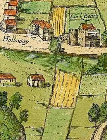
It was probably John Hull who remodelled the already ancient mansion between 1530 and 1550, making it one of the last great late medieval houses built either in or around Exeter. It is a fragment of this house which still survives today left. The castellated mansion of 'Larkbeare', with a gatehouse and round tower, is shown surrounded by fields and woods on Braun and Hogenberg's 1587 map of Exeter, detail above right.

Built of the local red Heavitree breccia, the house had three storeys, a cellar and at least one garderobe that emptied directly into the Shitbrook. A 16th century wooden garderobe seat from the house survives and is in the Royal Albert Memorial Museum in Exeter. The principal chambers had a series of elaborate oak coffered ceilings made from intersecting, richly-moulded beams.

By 1617 the property had been sold to Sir Nicholas Smith and by 1714 it belonged to an Exeter merchant called Andrew Lavington. Lavington's financial position was precarious and he eventually became bankrupt. In 1716 part of the house was being let by Lavington as a separate tenement. A notice in the Exeter Flying Post of that year states that the tenement is "the Fore Part of Larkbear House, without South Gate, Exon, containing a Kitchen with a little Room by, a large Parlour and a Cellar, with a Chamber over the Cellar; also 5 Lodging Chambers with 3 Closets; likewise a Garden; being very fit for a private family".

In 1737 Larkbeare House was bought by another Exeter merchant, John Baring, who was then residing at Palace Gate. Two of John Baring's sons, John and Francis, were later to achieve fame as the founders of Barings Bank. Baring's son John was born at Palace Gate and his brother Francis, later made a baronet, was born at Larkbeare. (The oldest merchant bank in London, Barings Bank collapsed in 1995 after the speculative investing of Nick Leeson.) In 1770 John Baring the second purchased the nearby Mount Radford estate and retired there from London. (Mount Radford house, built by John Baring around the core of Lawrence Radford's late 16th century mansion, was unfortunately demolished in 1904.)

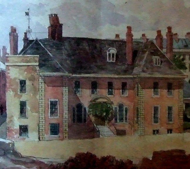
It was the Baring family who made extensive alterations to Larksbeare House c1740. The medieval core was retained but the property was extended and the exterior remodelled. A handsome 8-bay classical facade was added with two slightly projecting wings at either end. The image above right shows a watercolour of the northern end wall of the remodelled property c1850. The image below left shows a similar watercolour depicting the facade of Larkbeare House following the mid 18th century alterations. Holloway Street can just be seen on the left. The mid 19th century townhouses of Lansdowne Terrace are in the background on the right. Both images are © Devon County Council.

In 1889 almost the entire building was demolished. The garden was destroyed and the terrace houses of what is now Roberts Road were built on the site of the old estate. Only the small part of the property adjacent to Holloway Street was left standing.

This remnant of old Larkbeare House is now No. 38 Holloway Street and is Grade II listed. From the outside the house appears to contain little of interest but the ground floor still has a remarkable oak coffered ceiling from what was perhaps the parlour of the great 16th century mansion. There is also a large three-bay room on the second floor  which has retained its fine arch-braced roof. It's difficult to know what else remained of the 16th century house when the property was largely demolished. But it's clear that, at the very least, Exeter lost an attractive Georgian mansion close to the city walls.

An article from 19 April 1890 in the 'Exeter Flying Post' regarding donations to the Royal Albert Memorial Museum suggests that more of the late medieval property existed before 1889 than does today. It was reported that "Mr G. Diggines has given a number of carvings in stone from the old Larkbeare House, lately demolished; and these it is hoped may some day be built into some portion of the museum". Two of these "carvings in stone" are now on display in the museum. One of them, shown at the top of this post, is a beautiful stone doorway. According to the museum, the doorway is "late gothic in style, with foliage ornament in the traditional manner of pre-Reformation days, swallowed at the foot of the doorway by a grotesque head". The other carving is the fragmentary remains of a colossal stone lintel that once spanned a fireplace within the house, above. I'm not sure what the animals mean. Maybe they had some heraldic significance.

The story would end there if it wasn't for a 'Dangerous Structure Notice' served on the surviving fragment of the building in 1977. Following this the owner of the property, BP oil, wanted to demolish the 16th century remnant. A public inquiry was held during which Exeter City Council and the Department for the Environment combined forces to compel BP to restore the building. The council and department won their case and BP consequently sold No. 38 Holloway Street to the Devon Historic Buildings Trust for the sum of just £1. The property was in imminent danger of collapse but, helped by financial support from Exeter City Council, the trust restored the house, converting it into a two-bedroom dwelling and retaining all of the historically important features.

The photo above left shows the facade of No. 38 Holloway Street today following some brick additions made at the end of the 19th century. It's hard to believe it's the same building as that is shown in the mid 19th century watercolours. The image below shows what old Larkbeare House would might look like from Holloway Street had it not been demolished in 1889.


Sources

Friday, 22 March 2013

44-46 Magdalen Street: The House of John Matthew

In terms of the destruction of individual buildings rather than entire streets, the demolition of Nos. 44-46 Magdalen Street in 1977 ranks as one of the most shameful post-war acts of vandalism committed against Exeter's dwindling historical fabric. It even equals the unforgivable demolition by the city council of the late medieval open halls at Nos. 36 and 38 North Street in 1972. 

The photograph above © Express & Echo shows Nos. 42-46 Magdalen Street just prior to their demolition in June 1977. All the properties were Grade II listed buildings, but Nos. 44-46, highlighted in red, were of particular historical and architectural interest. The story begins at the end, with the creation of the inner bypass in the 1960s and 1970s. The destruction that ensued outside the South Gate is covered here, but to recap: the area where Nos. 44-46 Magdalen Street stood was deliberately burnt in 1645 by the Royalist defenders of the city during the English Civil War. Following the war the area around the junction of Magdalen Street with Holloway Street was gradually rebuilt, the empty plots being filled up mostly by the timber-framed homes of the city's merchants. The area remained rich in 17th century houses until they were all demolished for the creation of the inner bypass road system. Nos. 44-46 was one of the casualties, torn down in 1977.

The image right shows an aerial view of the area today. The buildings that comprised John Matthew's mansion are highlighted in red. It stood almost on the corner of Magdalen Street with the entrance into Southernhay. The photo below shows the grassy verge where the listed buildings once stood.

The property had received Grade II listed status on 18 June 1974, along with Nos. 42 & 43. Unfortunately, when the property was surveyed its architectural importance was completely overlooked. It wasn't uncommon for the survey merely to include the exterior of the buildings and to leave the interior unassessed. This was presumably what happened with Nos. 44-46 Magdalen Street. All five buildings, Nos. 42, 43, 44, 45 and 46 were listed as a "three storey stucco range probably circa 1830" with "moulded window architraves" and "good contemporary door surrounds". The city council purchased the buildings as part of the inner bypass construction and then wilfully neglected them. According to David Pearce, "council-owned, council-neglected, then council-condemned was all too frequently the fate of listed structures impeding redevelopment". Having allowed them to fall into disrepair the council then issued a Dangerous Structure Notice that circumvented their listed status and provided the perfect excuse for their demolition.

In June 1977, just three years after the buildings had been given listed status, work began on tearing them down. But during the demolition it was discovered that part of the listed group, Nos. 44-46, didn't date to c1830. It was actually the mid 17th century house of John Matthew, and it proved be one of Exeter's most architecturally important buildings. 

Following the damage caused during the English Civil War, one of the first properties to be built on the war-ravaged land outside the South Gate was the mansion of John Matthew. I don't really know anything about him. He was clearly wealthy, as will be seen from the house he built for himself, and it's possible that he was one of the men appointed to the city chamber in 1684.

The house was built on an L-plan and it was built of brick. This made it hugely significant. There is some debate over which is Exeter's earliest surviving brick building. The Custom House, constructed between 1680-81 is often cited as the earliest. Other candidates are The Notaries' House in Cathedral Yard right, which was probably built c1692 and No. 40 High Street, which has a facade of c1700 Other late 17th century brick facades survived into the 20th century in Fore Street and Paris Street but both have been demolished. The magnificent Pinbrook House in Cheynegate Lane on the outskirts of the city is brick-built and is dated to 1679 below left. Paragon House at 75 South Street was a late 17th century brick house but it was destroyed during the Exeter Blitz, below right. Another large brick-built property was Holloway House of c1700 but it was demolished by the city council in 1980. 

Although brick-built houses were popular in Exeter throughout the latter-half of the 18th century they were rarely used for major construction work before 1700. One reason was the cost of importing bricks and the material wasn't manufactured locally, even on a limited scale, until the middle of the 17th century. Before then most new houses built in Exeter were timber-framed with bricks only being used, from the beginning of the 16th century onwards, for fireplaces and chimneys. The first recorded large-scale use of brick in Exeter is in 1657 following the end of the English Civil War. £100 was spent erecting a brick wall over the choir screen inside the cathedral to divide the Presbyterian and Independent congregations. John Matthew's house was built just two years later making it, by some measure, the earliest known fully brick-built house to be constructed in the city and probably in Devon.

During the demolition of the house in 1977 a massive beam was discovered carved with the date 1659 and the initials I.M for 'John Matthew'. At the time of its destruction the property still contained 17th century panelling, two 17th century fireplaces and a fine 17th century staircase along with other original features. It was built with three storeys and had a cellar. It seems that the importance of the house had been lost until it was being destroyed. 

Around 1830 the property had received a modified stucco facade, the one recorded in the 1973 assessment, and was divided into three separate units, Nos. 44, 45 and 46 Magdalen Street. This is why, from the exterior, the house appeared to date to the 19th century. In reality the core of the building remained a single mid 17th century structure. Once the significance of the discovery was realised work halted on the demolition and an archaeological survey took place. Following the completion of the survey the destruction continued until the house had been razed to the ground. As if the demolition of Nos. 44-46 wasn't bad enough, the location where it stood didn't even impede the construction of the inner bypass. The road system completely missed it and the empty ground was left vacant until part of the charmless Southgate Hotel was built over it. It would've been perfectly possible to build the inner bypass and leave John Matthew's house standing.

Until the recent refurbishment of the city's Royal Albert Memorial Museum it was possible to view a large model of the property showing its massive scale, its surviving brick walls and the position of mid 17th century beams found during the archaeological survey. I managed to take a photo of it before it was mothballed above left

The original beams are shown slightly darker than later additions. It's pretty obvious that a lot of the 1659 mansion had remained intact until it was destroyed in 1977. Unfortunately, since the museum reopened, it seems that the model has now been relegated to the store room along with its tragic tale. It's a story that needs telling though as it was an important building and its pointless demolition was utterly reprehensible. The digitally-altered image below shows what Nos. 42-46 Magdalen Street might've looked like today if they had been restored rather than destroyed.


Sources

Saturday, 16 March 2013

The Archdeacon of Exeter's House, Palace Gate

It might not look much from the outside but this complex of different buildings is one of the most historically and architecturally important properties in Exeter. Grade I listed, it has a recorded history stretching back nearly 900 years. And most remarkably of all, behind the uneventful facades is one of the finest surviving structures from Exeter's rich medieval past: a spectacular early 15th century roof that once crowned the property's Great Hall, shown left in 1995 © Exeter Archaeology.

The history of what is known as the Archdeacon of Exeter's House is very long and very complex as it has been altered numerous times over many centuries but it began life in the middle of the 12th century. A property on this same site is recorded in documents from c1150 and c1188. A deed from c1210, cited by Lega-Weekes, refers to "land and houses" belonging to the Archdeacons of Exeter* that were "next to the Bishop's court", "adjoining the Bishop's gate" and "next to the gate of the Lord Bishop of Exeter". This places the early 13th century "land and houses" in the same place as the Grade I listed structure today, close to the grounds of the Bishop's Palace and almost adjacent to the palace's gatehouse.

Although known as the residence of the Archdeacon of Exeter, for some of its existence the building was also used by the medieval Archdeacons of Cornwall.

One such archdeacon, Walter, is believed to have begun the current property, specifically the great hall, in around 1200. A 13th century document in the cathedral's archives refers to "the great Hall which Walter, Archdeacon of Cornwall constructed". 

By the end of the 15th century the residence had reverted back to the Archdeacons of Exeter, by which time it had achieved its late medieval form. By at least 1500 the residence was a courtyard house, a form found at nearly all of Exeter's great ecclesiastical residences during the end of the Middle Ages e.g. the townhouses of the Abbots of Tavistock, the Abbots of Buckfast Abbey and the Priors of Plympton Priory as well the Chantry, the Chancellor's House and several canons houses in the Cathedral Close. These houses were distinguished by the presence of a gatehouse, a great hall, a chapel and private chambers built in ranges around a central courtyard as well as stables and accommodation for servants. 

The front gatehouse range at the Archdeacon of Exeter's house at Palace Gate has since been demolished but it is visible in the plan of Palace Gate and South Street drawn by John Hooker in the mid 16th century, above right. The 'Great Hall' is still essentially the building painted a sort of salmon pink in the photo below, though much altered. 

The late 19th century brick building to the far right in the same photo corresponds with the 'Chamber Block' on Hooker's plan, fragments of which survive in the present structure. Hooker hasn't included the late medieval range to the north, parts of which survive in the unit known today as the The Coach House. With its end wall facing into Palace Gate, part of the white wall and roof of The Coach House can be seen to the left in the photograph below.

The gatehouse range was perhaps the first part of the residence to be demolished and it doesn't appear on Caleb Hedgeland's early 19th century model of Exeter in 1769. In a detail from the model above left some of the residence's buildings have been highlighted in red. The approximate location of the missing gatehouse range is highlighted in purple. It's easy to see how the late medieval buildings would've been arranged around a central courtyard. (What does appear on the model is the old Palace Gate, spanning the narrow street close to the missing gatehouse. One of the gated entrances into the cathedral precinct, the Palace Gate originated in the late 13th century. Not to be confused with the surviving gatehouse to the Bishop's Palace, the Palace Gate was demolished in 1812.)

The Archdeacon of Exeter's House was massively altered around 1830 when the surviving ranges were remodelled and further additions were made in the late 19th century. In 1896 the property was purchased by a Roman Catholic convent from William Peters, a former mayor of Exeter, and it was used as the Presentation of St Mary Convent School.

The school added an enormous two-storey brick-built chapel in 1928 and the property remained as a school until 1996 when it was closed and the buildings sold. In the late 1990s the school buildings were subdivided into six separate residential units. Fortunately the architectural significance of the site has resulted in the preservation of the most important historical features.

Despite all of the alterations, the property retains three late medieval buildings at its core. Part of the medieval chamber range survives to the south, along with what is possibly the site of the chapel under an addition from 1908. The north east range, now known as The Coach House and next to the gatehouse of the Bishop's Palace) is also late medieval in origin and part of the original roof survives.

However the most astonishing survival is the roof of the medieval great hall, now part of a unit called The Tudor House. During the modifications of the 1830s a new parallel frontage was added to the great hall (now painted salmon pink) completely disguising its origins, and the space was carved up into smaller rooms, a process that already seems to have begun in the 17th century. It was divided horizontally to make two floors and the roof appears to have remained almost forgotten, hidden above later ceilings, until it was practically rediscovered during an archaeological survey in the 1990s, a discovery of such importance that it increased the listed status of the building from Grade II to Grade I.

The roof of the great hall has six bays, twice the number of bays as at the almost contemporary roof of the Law Library. It is designed as a series of variant base-cruck trusses with intermediate trusses. The tie beams are richly moulded and there is evidence for carved bosses at the junctions of the intermediate trusses, purlins and windbraces. Some of the spandrels are infilled with boards pierced with decorative cinquefoil-headed mouchettes. Tree ring samples taken from the oak structural timbers returned a felling date of between 1415 and 1440.

The structure therefore forms part of a local group of outstanding medieval roofs around Exeter which includes two roofs at Bowhill above left just beyond the city walls, and one each at the Guildhall right, at the Law Library below and at the Deanery. Unfortunately the roof at the Archdeacon of Exeter's House isn't viewable, and it is still hidden above the later ceilings, but it has been described by English Heritage as "one of the finest 15th century roofs in southwest England, of national importance and distinguished by its base cruck form, upper roof construction and the quality of its moulded and carved detail." These roofs really are one of the city's greatest glories.

It's hard not to be impressed by Exeter as it was in the 15th century. The late Middle Ages was one of the cultural highlights of the city's 2000 year history. Just within the 93 acres of the city walls there was Rougemont Castle, the Cathedral, the recently rebuilt Guildhall, numerous small parish churches, a sprawl of spectacular ecclesiastical residences, a Benedictine monastery, a Dominican friary, medieval gatehouses within the city wall, medieval gatehouses within the wall of the cathedral precinct and a large number of impressive timber-framed merchant houses. It was the county town of Devonshire and the great capital of the southwest peninsula of Britain, a status reflected in the architecture of the city itself.

*The story of Exeter's archdeaconries begins with the Anglo-Saxon Leofric who, in 1050, became the first Bishop of Exeter. It was probably Leofric who introduced an archdeacon at Exeter, a huge diocese that covered all of Devon and Cornwall. Following the Norman Conquest such large dioceses in England proved difficult to manage for a single bishop and so, from the 11th century onwards, they were subdivided into separate archdeaconries. An archdeacon was appointed to oversee his own particular archdeaconry in which he could act in the absence of the bishop (who was often away at the Royal court or on the Continent). By the end of the 11th century there were four archdeacons at Exeter, one for each of the archdeaconries of Exeter, Cornwall, Totnes and Barnstaple. Between them they effectively covered the whole of Devon and Cornwall and, eventually, each office came with its own house within the cathedral precinct at Exeter. The Diocese of Truro was formed out of the old Archdeaconry of Cornwall in 1876.

Sources

Wednesday, 21 March 2012

Bear Street, Bear Gate & Bear Tower

Today Bear Street hardly exists. The north side is nothing but a car park hidden behind a modern wall and the south side is completely dominated by the side wall of a late 19th century church left. But the area is thick with history and Bear Street, just 180ft (56m) long, was the site of several structures of significant historical interest. Traces of its medieval past remained until 1966 and yet none of it now survives. So what went wrong?

The site of Bear Street is ancient, lying within the boundaries of the mid-1st century Roman fortress. In 1953 part of a Roman drain or conduit was found in Bear Street. The drain carried waste water away from the public baths which stood near the Deanery's garden c180 AD. There is some archaeological evidence that Bear Street was first laid out on its current alignment as early as the 9th century. It might've once connected South Street with the Anglo-Saxon minster which stood just west of the present Gothic cathedral. According to this theory, Saxon Bear Street would've been much longer than it is today, extending across the city as far as what is now Princesshay. The street was considerably shortened in length when the boundaries of the cathedral precinct were established and by the end of the 13th century it only led to Deanery Place and Palace Gate, as it still does today. In 1286, following the murder of the precentor Walter Lechlade, the Dean and Chapter received a royal licence from Edward I to encircle the cathedral precinct with a wall and gatehouses, and one of these gatehouses was situated in Bear Street.

The Bear Gate

A document relating to the circumvallation gives quite precise details about the location of the gate, later known as Bear Gate. It was located at the top of Bear Street and consisted of one gate 8ft wide for pack-horses leading into "the lane between the house of the Dean of Exeter and the house now of Roger de Derteford". The gate had wooden doors that were locked every evening at the curfew. It must've been a relatively simple structure, especially in comparison with the great Broad Gate on the High Street. Hooker's 16th century plan of South Street shows Bear Gate with a simple pitched roof. On the Braun and Hogenburg map of 1587 the gate consists of just a stone archway right. The range of buildings on the right side of the street formed the north wall of the Bear Inn, the former townhouse of the Abbots of Tavistock Abbey.

There's some evidence that by 1584 the gate had a chamber above it as a Mr Barcombe was required to pay two pence every year in consideration of "his new building over the gate going into the churchyard by the said Bear Gate". The Bear Gate was demolished in the Spring of 1813. According to Michael Fodor in his booklet 'Gates of the Close', the materials were salvaged by Thomas Matthews for £10.

The Bear Tower

Of almost equal interest was the Bear Tower. It was embedded within a later property, close to the junction with South Street and opposite the side wall of the Bear Inn. It dated at least to the 14th century and was built from blocks of purple volcanic trap. A blocked Gothic doorway in the south wall of the tower once gave access directly onto Bear Street. There was also a very large blocked archway in the east wall, almost like the chancel arch of a church. The tower was perhaps 20ft high and approximately 15ft square at the base. Jenkins saw it in 1806: "The opposite corner of Bear Lane bears evident marks of antiquity. According to tradition it was a Nunnery". Lega-Weekes also recalled seeing the property in 1915: "The ancient side wall of the house at one corner of Bear Lane shews traces in its masonry of a large arched window or doorway at first floor level, and a smaller stopped window above that; and this, like other old masonry in the house is about three feet thick".

The drawing above left © Devon County Council is by local artist John Gendall and dates to c1840. It shows the interior of the Bear Tower. The partially open door which once exited onto Bear Street is visible in the centre. A stone spiral staircase can be seen rising through the centre of the tower. (The staircase was removed c1860.) No-one knows the function of the Bear Tower. Jenkins believed it was related to an Augustinian nunnery which was possibly on this site. It's also possible that it was connected to an earlier phase of the townhouse of the Abbots of Tavistock, on the other side of the street. The townhouse was reputedly rebuilt in 1481 and perhaps the Bear Tower was part of the earlier townhouse. The Bear Gate always seems to have been located at the other end of Bear Street so it's unlikely that the Bear Tower was related to that. The purpose of the tower remains a mystery. The image below right shows Bear Street as it appears on Hedgeland's early 19th century model of Exeter.

During the Exeter Blitz of 1942 the early 19th century house which had been built around the Bear Tower was destroyed by fire. But the fire was no match for the tower's thick masonry and a significant amount of the 14th century structure remained standing (much like the Gothic windows and medieval walls at the Black Lions Inn on the other side of South Street). The Bear Tower stood on the corner of Bear Street and South Street for a further 24 years.

Despite being listed as one of Exeter's ancient monuments in the 1950s, in December 1965 the city council obtained permission from the Minister of Public Works to demolish the tower completely. In an act of either gross stupidity or pig ignorance, the remains of the 14th century building were destroyed in January 1966. It's not surprising that some people believe the philistine post-war city council merely finished what the Germans had already started in 1942. The government had stipulated that the foundations be left preserved and exposed. Naturally, this didn't happen and today the site of the Bear Tower is a flower bed.

Nos. 2 to 8, Bear Street

The image left shows a detail from the 1905 OS map of Exeter overlaid onto an aerial view of the same area. Properties demolished since 1905 are highlighted in red.

The Bear Tower wasn't the only historical structure on Bear Street which managed to stagger into the 20th century. Nos. 2 to 8 Bear Street occupied almost the entire north side of the street, facing out onto the side wall of the Bear Inn (and later the Roman Catholic Church of the Sacred Heart). An auction annoucement in 1809 stated that several of these houses, "situate adjoining Bear Gate, and fronting Bear Lane" were held "by lease under the Dean of Exeter". In fact all of these properties on the north side of the street were owned by the Dean and Chapter and were part of the boundary between the city and the cathedral precinct.

In the summer of 1871 the 'Exeter Flying Post' carried a report that the Dean, in conjunction with the city council, had decided to authorise the widening of Bear Street "on the north side by fifteen feet throughout, from the junction with Palace Street to the last house fronting South Street". The fronts of the houses on the north side of Bear Street were all apparently set back to allow the road to be widened. I'm not convinced that this actually happened to the extent suggested in the newspaper report. Either way, the rears of Nos. 2 to 8 Bear Street were much older than the street facades. Arthur Everett examined the row of properties in the 1930s and discovered that the back walls and roofs dated to c1500. The great age of the buildings was of little consequence as the entire lot was demolished in 1938. It never seems to have occurred to the local authority that Exeter's stock of medieval housing was a finite resource. It's a sobering thought that more medieval and early post-medieval buildings were probably demolished in Exeter between 1900 and 1939 than were ever destroyed during World War Two.

The location of the ancient houses today is a car park partially hidden behind a shabby wall. There's now no sign above ground of the Bear Gate or the Bear Tower, the ancient houses or the old Bear Inn. The photograph below shows the site of the Bear Tower, the foundations lying somewhere beneath the flowerbed to the right of the remarkably poor flat-roofed post-war shack on South Street. The entrance into Bear Street is visible to the far right.

Sources

Saturday, 10 March 2012

The Chantry, Deanery Place

The role of the precentor at Exeter has been established since at least 1154 when John the Chaunter is recorded as being the first holder of the post. The title comes from the Latin 'praecantare', meaning 'to sing before', and it was the precentor's job to oversee music and liturgy associated with masses held in Exeter Cathedral

By the end of the 13th century it had evolved into a very significant position and, along with the dean, treasurer and chancellor, was one of the four most senior roles associated with the cathedral's hierarchy. Each of these roles came with a significant property, and the Chantry in Deanery Place was the precentor's residence.The city's most ill-fated precentor was probably William Lechlade, murdered in 1283 as he was returning to the Chantry. His death, in which the dean himself was involved, led to the construction of a large wall dotted with gatehouses around the perimeter of the cathedral precinct. The Chantry stood on a plot of land within this enclosure, bounded by Bear Street to the north and Palace Gate to the south, its front range overlooking a small open area known as Deanery Place. Unfortunately the property was completely demolished in the 1860s and only a handful of images exist which depict the structure prior to its destruction.

The image top shows a detail from Hedgeland's model of Exeter overlaid onto a modern aerial view of Palace Gate. The long building at the top of the image with the red-tiled roof is the Deanery. The quadrangle of the now-demolished cathedral cloisters is to the right. The extent of the Chantry site as depicted by Hedgeland is highlighted in red, separated from the street by a wall. Alas, it seems that Hedgeland's modelling of the buildings is inaccurate in this instance.

An almost contemporary description by Alexander Jenkins in 1806 stated that the Chantry was "a very ancient and roomy house, entirely surrounded by other buildings, and no part of it is to be seen except the entrance, which has a modern frontispiece." Writing after the Chantry had been demolished, Lega-Weekes recorded in 1915 that "I am told that the old mansion of the Precentor was hidden from view by smaller houses, and was entered through a narrow passageway between them". Fortunately enough information about the building is known to say at least something about it. The image above right depicts the precentor's coat of arms: a blue saltire against a silver background with a gold fleur-de-lis in the centre. It was in use by 1496 and was possibly used prior to 1477.

Perhaps the earliest depiction of the Chantry can be found on Hooker's plan of South Street c1560. It shows the Chantry as a sprawling complex of boundary walls, buildings and courtyards entered through a gatehouse in Deanery Place. Beyond the gatehouse is a large three storey building with an embattled parapet left. Other than the gatehouse and the large embatttled structure, it's difficult to know exactly which of the buildings and courtyards shown by Hooker were associated with the Chantry but the plan does give some idea of the significant extent of the residence in the 16th century and its prominence in the overall cityscape.

The very early phases of the building's construction are a mystery but a 17th century document provides a good description of what was probably the Chantry's late medieval form. Like other residences which belonged to the Dean and Chapter, the Chantry was confiscated during the Commonweath which followed the execution of Charles I in 1649. A document surviving from the sale of the Chantry on 23 June 1655 contains the following invaluable information. In 1655 the complex of buildings measured 120ft (37m) from west to east and 92ft (28m) from north to south. In the centre was a courtyard 40ft (12m) square. The gatehouse had one room on the right and two rooms on the left with a further four chambers above. In the courtyard, to the left, were stables with a loft above and a woodhouse. On the right was a porch leading to a "faire hall". The accommodation consisted of at least one hall, two parlours, one kitchen, two butteries and nine chambers with two further chambers in a third storey. Slate roofs covered the buildings and behind the property was a large garden measuring 110ft (34m) by 72ft (22m).

The description almost certainly records the Chantry's medieval plan. It was a courtyard house constructed around a central quadrangle with a range of buildings on each side, not dissimilar to other examples that once existed in the city.


These properties would've been amongst the most opulent domestic buildings in the city, far exceeding the houses of all but the very wealthiest of Exeter's merchants. It's unlikely that secular domestic buildings on the same scale existed within the city walls until after the Reformation and the construction of Bampfylde House and Bedford House in the 16th century. Based on the 1655 dimensions, the medieval Chantry covered an area only slightly smaller than the open ground within the former cloisters of the cathedral. Something of the courtyard arrangement at the Chantry can be seen in John Hooker's 16th century plan. Assuming that it had been remodelled in the 15th century the Chantry was almost certainly constructed from red Heavitree breccia. The exterior of the gatehouse range at least would've looked a little like some of the remaining canons' houses in the Cathedral Close e.g. No. 11 above (the former gatehouse to the Abbot's Lodge, No. 11 was completely rebuilt after almost total destruction in World War II).

Only one single image is known to exist showing anything of the interior of the Chantry prior to its demolition i.e. a photograph from c1868 of the much-modified John Coombe fireplace in the great hall. One other possible image is in the Westcountry Studies Library. Dated to c1840 it is a sketch by the Exeter artist, John Gendall. It is catalogued as 'The Old Hall of the Chantry, now the Law Library' left © Devon County Council. The magnificent medieval hall known as the Law Library is at No. 8 Cathedral Close and has a completely different roof structure to the one in the sketch so clearly it must show a different building. I've been told that the roof shown in the sketch isn't one which is still extant within the city but that the principal and intermediate roof trusses are characteristic of other high-status Exeter medieval roofs. I can find no record of the Chantry ever having been used as a Law Library but it's quite possible that this sketch does indeed show the "faire hall" of Exeter's medieval precentors.

The arch-braced principles with short curved ends and the very distinctive curving wind-braces shown in the sketch remind me of the 15th century timber roof in the guest hall at St Nicholas' Priory right, although the arrangement of the wind-braces is quite different at the priory. To the bottom left of the sketch can be seen a cross-section through the hall showing three doorways that led to the service rooms. Debris on the floor also suggests that the sketch was made at a time when the mystery room was undergoing either demolition or alteration. Either way, the guest hall at the priory gives another small insight into what the medieval Chantry was like.


Following the sale of the Chantry in 1655 it was possibly used as a hospital for soldiers incapacitated during the English Civil War. It was returned to the Dean and Chapter after the restoration of the monarchy in 1660. It's difficult to know what state it was in by the end of the 17th century. The nearby Bishop's Palace was severely damaged during the Commonwealth when it was used as a sugar refinery. The only known 19th century illustration of the exterior of the Chantry, by George Townsend in 1867 below left © Devon County Council, shows that the building had undergone major alterations in the 18th or early 19th centuries. The fact that the Chantry was no longer visible from the street in 1806 suggests that some of its ranges and the land on which it stood had been subsumed into later housing.

Townsend's drawing depicts a large, square, three-storey extension with a porch, probably added in the 18th century. Attached to one side is a long, low building which is probably one of the surviving medieval ranges of the main residence, possibly that which contained the great hall. All of these structures are absent from Hedgeland's model. The south tower of the cathedral can be seen in the background to the right.

George Oliver lamented in 1860 that "the residence of the precentors has been so altered and modernised as almost to defy description". That may well have been the case but medieval elements from the earlier building must've remained embedded within the later alterations. It's highly likely that the "faire hall" mentioned in 1655 and possibly sketched by Gendall in the 1840s survived up until its destruction in the 1860s. An article in the 'Exeter Flying Post' from 1871 explicitly stated that the Chantry contained "a fine dining hall with an open roof...which had long since been converted into bedrooms". Clearly the hall had been divided horizontally at some point, as happened at the Deanery, with a first floor inserted but there's no reason to doubt that the medieval roof structure remained largely intact (as also happened at the Deanery).

Unfortunately the entire site was razed to the ground in the 1860s. The only surviving piece of the former Chantry today is the John Coombe fireplace, now in the Royal Albert Memorial Museum. The site remained empty for some time before it was occupied by a new Chantry building.

Designed by Ewan Christian, architect for the Ecclesiastical Commissioners from 1851, the property was completed in 1870 and it's hard to imagine a more stolid example of Victorian architecture. The diaper brickwork and stone door and window surrounds are small recompense for the loss of the old building. The modern aerial view right shows the extent of the 1870 Chantry, highlighted in red. The boundary wall is highlighted in purple. It still retains the pronounced curve to the north-east that is recorded both by Hooker in the 16th century and Hedgeland in the early 19th century. The former gardens are now all concrete and car parks.

The lack of a visually impressive front facade is particularly bizarre as each side looks as nondescript as the others. The overall appearance isn't helped by the fire escapes or the wire fencing which sits on top of part of the boundary wall. The demolition of the Chantry was criticised in a letter to the 'Exeter Flying Post' in 1894, in which it was described as one of the "priceless relics of the past" destroyed by often unnecessary rebuilding. There have always been people in Exeter who have lamented the demolition of the city's historical buildings, or the sale of historical artifacts, but such opinions have only rarely altered the outcome. The Chantry is now a locally listed building but its boundary wall has Grade II listed status, the lower courses of purple volcanic trap and sandstone dating back at least to the 18th century. Apart from that, there's nothing of historical interest to be seen above ground. The Chantry is no longer the precentor's house but is used as part of the Exeter Cathedral School.

Sources

Friday, 9 March 2012

St Pancras Church & Pancras Lane

The small church dedicated to St Pancras is a remarkable survival. Narrowly escaping demolition, it now stands within the 1970s' Guildhall Shopping Centre, stripped of all its historical context and "incongruously dished up on a platter of municipal planting in the middle of a paved square" (Pevsner and Cherry). The medieval street plan which surrounded the church until the mid-20th century suggested an ancient origin but this has unfortunately been swept away. The foundation itself though is ancient, as is much of the still-standing building, and it's possible that St Pancras church occupies the earliest site of Christian worship in Exeter. There has been some speculation that the church was founded by the Romano-British Christian citizens of Isca Dumnoniorum, the Roman town which evolved out of the Second Augustan Legion's fortress in the first century AD.

Christianity had been imported into the British Isles centuries before St Augustine founded the Diocese of Canterbury in 597. The church at Exeter's patron saint was probably St Pancras of Rome, a 14-year-old martyr who was allegedly killed on the orders of the Emperor Diocletian in Rome c304 AD and who was one of the first martyrs to be venerated by the early Christian church. Unfortunately, apart from some bits of Roman tessellated pavement excavated from around the church, there is little actual evidence to support the claim of a Roman foundation. The theory seems to rest on an early 19th century tradition that the Roman praetorium stood in the vicinity. Jenkins repeats the tradition in his 1806 history of the city and it had been repeated by numerous commentators ever since. The Roman pavements were probably installed in the corridors of private houses.

The church is referred to in 1191 but it's highly likely that the foundation is pre-Conquest in origin even if it doesn't date back to the Romans. There is some evidence that the remains of a Saxon doorway were found embedded in the south wall of the chancel during restoration in the 19th century. The Anglo-Saxons did have a number of churches in Exeter, including St George, St Martin, St Olave and a monastery in what is now the cathedral precinct. St Pancras was almost certainly another, very early foundation.

For over a thousand years the church stood on a narrow street called Pancras Lane. A detail from Hedgeland's early 19th century model of Exeter above right gives a good idea of the medieval layout of the church and surrounding street plan. It remained little altered from the Middle Ages until the middle of the 20th century. The church is highlighted in purple. The now-vanished buildings which fronted onto Pancras Lane are highlighted in red. The street had a very noticeable dog leg in it, even more exaggerated than a similar one formerly in Mary Arches Street. Quirks in an old street plan are always interesting. Maybe there was a Saxon enclosure around which the street was forced to make a detour, as is believed to have been the case at Mary Arches Street. Either way, the church probably predated Pancras Lane itself.

Pancras Lane connected Paul Street with Waterbeer Street. Another route off Pancras Lane was Trichay Street. Until 1349 it was possible to walk from Pancras Lane down Trichay Street and into North Street. Although blocked up in the 14th century by the rectory for St Kerrian's church, Trichay Street survived as a route until the 1970s. It's interesting to compare the image above left with the Hedgeland model. It shows a detail from the 1905 map of Exeter overlaid onto a modern aerial photograph of the Guildhall Shopping Centre. St Pancras church is highlighted again in purple. Pancras Lane is shown running past the church from Waterbeer Street and exiting into Paul Street at the top. The building plots highlighted in red have all disappeared since 1905. The photograph also shows the vast expanse of flat roofs and car parks of the Guildhall Shopping Centre which now covers much of this part of Exeter.

The photograph right © Exeter City Council shows a rare view looking down Pancras Lane towards Paul Street c1937. The photograph indicates that even in the 1930s the street still retained its built-up character with properties lining both sides of the narrow thoroughfare. The buildings might've been different but this had been the character of the street since the Middle Ages. The covered passageway visible to the left of the car led into Arthur's Buildings, a courtyard with properties on either side.

Most of the buildings on Pancras Lane were deliberately removed between c1937 and 1951 as part of the city's council's planned redevelopment of the area behind the Higher Market. This left most of the ancient street as little more than a large car park. The alignment of the street had already been altered when the police station on Waterbeer Street was constructed in 1887. The new police station also resulted in the demolition of several houses to the north-east of the church which, until then, had been "hidden from public view by the gradual accumulation of squalid tenements around it". The area was left unscathed by the Exeter Blitz but the church was threatened with demolition in the 1960s. Fortunately it was spared, and although the surroundings are now bland and mediocre the church itself is of genuine interest.

The plan is very simple, consisting of just a nave and a chancel with no aisles or porches or towers. The layout and the extremely small dimensions have been compared with the Anglo-Saxon church at Escomb in County Durham. Although the oldest parts of St Pancras date to the 13th century, the ground plan could well have remained unchanged since Saxon times. The walls have been patched over the centuries and the church today is largely constructed from blocks of purple volcanic trap with scattered blocks of sandstone, red Heavitree breccia and white-veined volcanic trap from Pocombe. This gives the church a quite different appearance to most of Exeter's surviving parish churches, many of which were rebuilt in the 15th century from red Heavitree breccia with dressed sandstone around the windows and doorways.

A number of descriptions of the church state that it's built from friable red Heavitree breccia but close examination of the walls show that this is clearly untrue. It seems likely that the church was rebuilt or overhauled in the 13th century. A two-light lancet window with Y tracery above left and a one-light lancet window, both in the north wall of the chancel, date to the 1200s. A three-light (restored) east window, also with distinctive Y tracery, is of a similar date. The insides of the chancel windows have round-headed rere-arches. These are some of the oldest surviving windows in any of Exeter's parish churches.

The three windows in the nave are of the mullion type and were probably installed in the 16th century although the nave itself also dates to the 1200s. The exterior of the west wall has a relieving arch embedded in it made of purple volcanic trap. I wonder if there was once a western bell tower here with an internal opening into the nave.

The 1587 Braun and Hogenburg map of Exeter shows St Pancras church. No tower is visible but there are two windows set into the west wall so perhaps the relieving arch took a single large window.

Inside the chancel is a piscina right, used for washing the communion vessels. It has a three-foiled cusped arch and also dates to the 13th century. It features a shallow bowl carved in the shape of a quatrefoil. Above it is a strange little niche. Cresswell believed it might've been an aumbry, used for storing chalices and other vessels, but it does seem a bit small. Maybe it was used to hold a small reliquary or the sacramental bread. The oldest visible feature in the church today is the 12th century circular font with a band of bead moulding around the top below left. According to Cresswell, the font was damaged by over-zealous restorers in 1831 who "scraped it until all traces of antiquity were well nigh scraped away". Compared with other Norman fonts in Devon, such as the superb example at Stoke Canon near Exeter, it does seem rather plain but it is also perhaps the oldest font in the city. (A more elaborately carved Norman font also survives at the church of St Mary Steps.) There's no reason to doubt that the font has been on the same site since the 12th century.

In 1658, during Cromwell's Commonwealth, the church was sold to its parishioners for £50. The parish register for St Pancras also records an earthquake which shook all the houses in Exeter on 19 July 1727: "It was felt all over England, and in some places beyond the sea". Jenkins described the church in 1806, stating that it "bears evident marks of great antiquity" and adding that "it is a very small and plain building, forty-six six inches in length, and sixteen feet in breadth.

The interior is dark and gloomy, consisting of a Nave and Chancel, the latter only is seated; the pulpit and font are very old. As no use is now made of this Church, excepting as a Cemetery for a few families, it is consequently very much neglected, and may soon be desecrated". The church wasn't desecrated but was partially restored in the 1830s. The church reopened in 1830 "having been disused for a number of years". The 'Exeter Flying Post' believed it hadn't been used "either wholly or partially since the execution of "Archbishop Laud"! Certainly untrue, but it does appear that the church was badly neglected throughout much of the 18th century. A 19th century sketch shows the church with a gaping hole in the chancel roof and smashed glass in the 13th century windows.

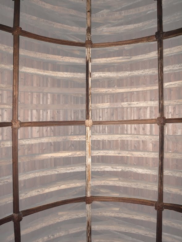
The roof of the nave right, although restored, dates to the 15th century. It has a barrel vault, a type also found at St Mary Steps, St Mary Arches (roof destroyed in 1942), St Lawrence (destroyed in 1942), St Olave (sadly hidden beneath a later roof), at St Martin and at Tucker's Hall in Fore Street (probably the finest of all).

The entire roof structure is now visible at St Pancras but in the 15th century the spaces between the ribs would've been covered in plaster. I've recreated the effect of the plaster panels to give a better idea of the roof's medieval appearance. Carved wooden bosses, once brightly painted, cover the points where the ribs meet. The church received a major restoration between 1887 and 1889, having been closed again for 12 years.

The work was carried out under the supervision of John Pearson, the Gothic Revival architect of Truro Cathedral and the partially reconstructed cloisters at Exeter Cathedral. For once, the Victorian 'restoration' was relatively sympathetic and didn't involve the complete reconstruction of the entire building. The chancel was in a particularly advanced state of decay and was rebuilt stone for stone, reincorporating much of the original fabric and all of the surviving 13th century features, such as the windows and the piscina (although unfortunately not the remains of the Saxon doorway). The chancel roof was rotten, having been left open to the elements for part of the 19th century, and so Pearson replaced it entirely with a wagon roof similar to the surviving 15th century roof in the nave.

The stonework of the 13th century east window was consolidated. Pearson believed that the east window was an insertion added into a pre-existing wall. Three carved fragments with Romanesque decoration were discovered in the walls of the chancel. These have now been inserted into the south wall of the chancel but they are so badly damaged that it's difficult to see them as anything more than ragged bits of stone. They appear to have been part of a corbel table, but whether they were originally belonged to the church itself or were recycled from another building in the city is unknown.

The photograph left shows the view inside the church looking east towards the chancel. It's clear to see how the apex of the nave roof and the apex of the chancel roof don't line up. Both parts of the church are built on a slightly different alignment suggesting two distinct phases of construction. The pulpit, just visible to the left, dates to c1600 and came from the church of Allhallows on Goldsmith Street when it was demolished in 1906. Pearson's one major error was in building a new chancel arch resting on corbels and using Bath stone, a material completely at odds with the rest of the church. Pevsner and Cherry called it "unsympathetic", and so it is. The arch had already been replaced with brick in the 1830s. Following Pearson's restoration, the church reopened on 02 June 1889. The lesson was read by the Archdeacon of Exeter and the Bishop of Exeter preached the sermon.

The church contains a few other interesting features. Pearson's work involved stripping all of the plaster from the walls. This action uncovered the arched doorway of the rood stair right, probably added in the 14th century. Built into the thickness of the wall was a stone staircase leading via an internal doorway at first-floor level to the rood loft above the rood screen (the screen, separating the nave from the chancel, was apparently removed c1800).

A few of these steps still remain in situ and the blocked up doorway of the rood loft can be seen as a scar high up on the north wall. The rood loft provided access to the top of the screen so that the great rood, an effigy of the crucified Christ, could be cleaned or decorated, or so that candles could be lit. The church had a number of floor slabs, the earliest of which dated to 1669 and commemorated the burial of Benjamin Board, one of the city's merchants. Unfortunately these slabs are now presumably covered by the modern flooring. The few wall memorials all came from Allhallows on Goldsmith Street. One of them records the death of Loveday, the daughter of Christopher Bellett. She died of smallpox in 1711. Four of her sisters died from the same illness in February and March 1717.

The photograph left shows the interior of the church looking towards the west wall. The church also has a single medieval bell hanging in a bell turret above the western wall. It was cast during the 15th century by the Exeter bellfounder, Robert Norton. It is inscribed, in Latin, with the motto: "I may be small but I am heard over a great distance". I've lived in Exeter for nearly 40 years and I've never heard it ring once.

The other particularly lovely addition is the fine late 19th century stained glass inserted into the east window below. It shows St Pancras of Rome, with Christ in the centre and St Boniface to the right. St Boniface is believed to have studied at a Saxon monastery in Exeter and the site of the monastery was thought to be close to St Pancras' church. (In reality the site of the monastery is almost certainly near the west front of the cathedral. The remains of the Saxon minster there were only excavated in the early 1970s.) The stained glass in the east window was the gift of Bishop Tozer, the first Bishop of Zanzibar. Beautifully executed, I don't think it would look out of place in one of the side chapels of the cathedral.

St Pancras church is well worth visiting for anyone who is in Exeter and hasn't yet been inside. As Hugh Meller says in his book 'Exeter Architecture': "St Pancras has survived. Miraculously it retains an atmosphere of tranquillity which most other central Exeter parish churches have lost and it serves as a constant reproach against the arid post-war development in Exeter represented by the Precinct that surrounds it".

Sources
Related Posts Plugin for WordPress, Blogger...