Showing posts with label Victorian Exeter. Show all posts

Sunday, 14 April 2013

The Destruction of the High Street in 1942


This is a follow-up to an earlier post, 'The Destruction of the High Street Before 1942', and a brief summary of the Exeter Blitz can be found here.

The photograph above from c1920 shows the view up the High Street looking east towards Sidwell Street. If nothing else it shows the wonderful architectural diversity of the pre-war High Street, the product of centuries of gradual evolution. The tower of St Lawrence's Church is about halfway up on the left. The entrance into St Martin's Lane is in the foreground on the right. Apart from the altered facades of No. 226 High Street and No. 227 High Street, and St Stephen's Church (whose weathervane can just be seen poking above the rooftops on the right), not one of the buildings shown in the photograph remains standing today.

Not all of the buildings shown in the image were destroyed in 1942. For example, the ornate stone bank on the corner of St Martin's Lane and the timber-framed house with oriel windows next to it (No. 37 High Street) were demolished in the 1950s. No. 229 High Street, just beyond the tram on the left, was demolished in 1930. But it does show the approximate extent of the wartime destruction of the High Street and a complete historical street scene which has disappeared forever.

Pevsner wrote that "the German bombers found Exeter primarily a medieval city, they left it primarily a Georgian and early-Victorian city. The close-knit pattern of medieval streets and alleys, medieval churches and houses is irretrievably gone". This perhaps needs some qualification. By the end of the 19th century, anyone wanting to experience a visual flavour of medieval Exeter beyond the Cathedral Close would've had to trek to the forgotten slums of the West Quarter, to Preston Street, Smythen Street, Frog Street and Stepcote Hill, to Paul Street, Mary Arches Street and parts of Catherine Street. By 1942 much of Exeter's surviving medieval fabric had already been swept away through slum clearances. The High Street itself had been one of the first parts of the city to experience modernisation in the 18th and 19th centuries. And on the surface at least, Exeter was far from being a medieval city.

But in a real sense Pevser was quite right. The fingerprints of the Middle Ages were still in evidence all across the city, primarily in its street plan, in the presence of the Castle, Cathedral and Guildhall, and in the survival of many of the medieval tenement plots, all of which were encircled by the majority of the medieval city walls. And there were almost certainly many medieval and early post medieval buildings hidden behind altered facades and embedded in later structures.

Unfortunately most of the individual tenement plots were eradicated between the post-war reconstruction of war-damaged areas and the various redevelopments of the 1960s and 1970s. During the same period much of the ancient street plan was either either rerouted or totally/partially obliterated e.g. George Street, Bampfylde Street, Milk Street, Goldsmith Street, Pancras Lane, Little Stile, Sun Street, Chapel Street, Guinea Street, Coombe Street, James Street, Catherine Street, Frog Street, Edmund Street, James Street, Musgrave Alley and King's Alley. Almost miraculously, the Castle, Cathedral and Guildhall still survive. Anyway, the High Street on the eve of World War Two was one of the most picturesque streets remaining within the boundary of the city wall, perhaps notable for its rich architectural variety than for any single building.

The Exeter Blitz began at around 1.50am in the early hours of 04 May 1942 and only lasted for about 80 minutes. 75 tonnes of bombs were dropped by 40 planes including 160 high explosives, parachute mines and around 10,000 incendiaries. The resulting fire was seen up to fifty miles away. By dawn 156 people had died, large parts of central Exeter lay in ruins and about 50% of the High Street, Exeter's foremost thoroughfare, had been irreparably destroyed.

. The image left shows the extent of war-damage in the High Street following the Exeter Blitz. It is based on a 1905 map of the city overlaid onto a modern aerial view of the same area. Only the section of the High Street affected by the air raid, around 50% of its total length, is shown.

The buildings on the tenement plots highlighted in red were nearly all completely destroyed down to ground level. Some had already been rebuilt prior to 1942 e.g. the Half Moon inn on the corner of the High Street and Bedford Street, but the High Street of 1905 was largely the same as the High Street of 1942. The late 19th century Post Office and Eastgate Arcade, which replaced St John's Hospital School, are to the right. A cross marks the site of the great medieval East Gate. The two most westerly pre-war buildings now surviving on the High Street are highlighted in purple: on the north side No. 229 High Street built in 1930, and on the south side St Stephen's Church. The image doesn't show the extensive network of courtyards, alleyways and smaller structures which existed at the back of the buildings fronting onto the High Street but which were also destroyed during the air raid. The gargantuan bulk of the Princesshay Shopping Centre which now squats on the site of Bedford Circus is easily visible to the south of the High Street. 

Drag the slider in the centre of the photographs below to see before and after images (or click on 'Show only then' or 'Show only now').


before
after

The photo above is from c1910 looking down the High Street towards the west. The brick entrance into the Eastgate Arcade is on the left. Slightly further down on the same side is the stone Gothic Revival facade of the main Post Office. The properties on the immediate right were built c1830 and marked the corner of the High Street with London Inn Square (now the site of 'Waterstones').

before
after

The photo above shows the High Street looking east towards Eastgate and, in the far distance, the start of Sidwell Street (now occupied by the tower block at Nos. 1 to 11 Sidwell Street). The Eastgate Arcade and Post Office are on the right. In the centre of the photo are the premises of The Cathedral Dairy Company (you can just see the lettering on the side of the wall). This was at Nos. 6 & 7 Eastgate, beyond the boundary of the city walls. The premises were converted out of the late 18th century residence of the headmaster of St John's Hospital School. The small, three storey timber-framed house on the left was No. 264 High Street. Before the start of the 20th century the date 1597 was written under the gable but by the 1930s this had changed to 1297! The late 16th century date is probably much more accurate. Unfortunately such externally ancient buildings were a rarity in the High Street by 1942. Next to No. 264 is a tall building with a gable end facing into the street, No. 265. This only dated to 1893 and replaced the much-earlier Apothecaries' Hall, formerly at No. 246 High Street.  Next door to No. 265 is the Georgian facade of Nos. 266 & 266 High Street, fashioned in the 1780s from stone recycled from the East Gate. Just about visible is a niche at first-floor level which contained the gatehouse's statue of Henry VII.
before
after

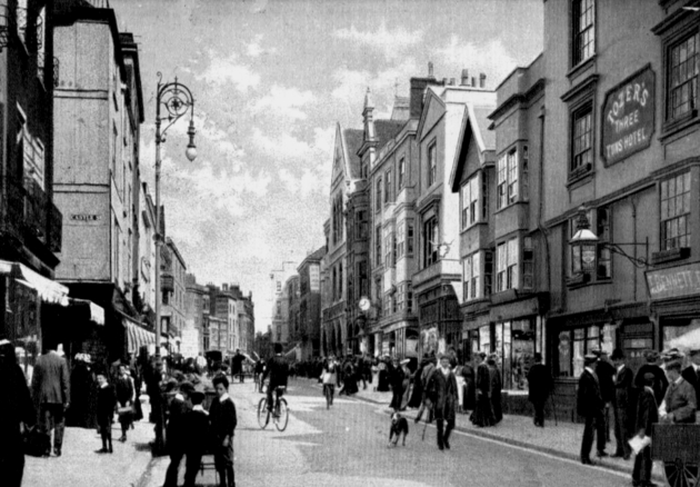
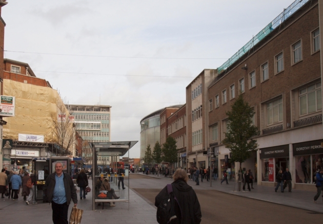
The photo above c1900 was taken looking in the same direction i.e. towards Eastgate. Electric trams had yet to be introduced into the High Street so the image dates to before 1905. If that dog was in the High Street today it would probably get run down by a minibus! The Post Office and Eastgate are still visible on the right. The entrance into Castle Street, which ran up to Rougemont Castle, is on the left. The entrance was much narrower before 1942 and was massively widened during the post-war reconstruction. The three-storey gabled house on the right, from c1600, stood at the High Street's junction with Bampfylde Street. Another very narrow street, Bampfylde Street was dominated at its far end by the magnificent Bampfylde House. To the far right is the Three Tuns inn at No. 8 High Street. In 1836, at the rear of the Three Tuns, workers unearthed a subterranean chamber described at the time as a "Roman sepulchral family vault". The chamber was 7ft square with an arched roof. Around the walls were niches containing five urns believed to contain the cremated remains of some of Exeter's Roman citizens. The inn closed in 1913 but the premises survived until they were destroyed in 1942.

before
after

The photo above dates to c1930 also showing the view towards Eastgate. The south wall of St Lawrence's Church is on the left. The former Three Tuns building, now missing its first floor windows, is the fourth along on the right. Apart from St Lawrence's Church and the stone Post Office, nearly every other building shown was destroyed to ground level during the Exeter Blitz. This was almost certainly a consequence of most of them being constructed in the 18th century or earlier on timber frames with lath and plaster facades. Next to St Lawrence's is the arched entrance into the Empire cinema, Exeter's first, a not particularly attractive addition from 1911. Comparison between the 'then' and 'now' photos vividly shows how much this part of the High Street was widened during post-war reconstruction.
before
after

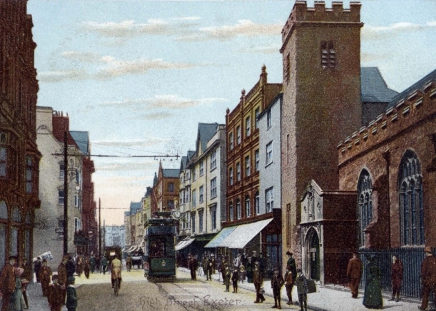
The photo above is taken from about the same place as the previous one but looking in the opposite direction c1910. St Lawrence's Church is on the right. Most of the building dated to the 15th century although the south wall, visible in the photo, was rebuilt in 1674. The stone for the porch was recycled from a late 16th century water conduit which stood close to the church until the conduit was demolished in 1694. The conduit was adorned with statues of Henry VIII and Elizabeth I. The statue of Elizabeth was placed above the porch when it was added to the church in the 1690s. Although the interior of the church was gutted in 1942 the south wall, medieval bell tower and porch survived the air raid only to be demolished during the post-war reconstruction. Running under the building to the immediate left of the church was a covered passageway which led, since 1692, to a small churchyard. Beatrix Cresswell described it in 1927: "Just beside the tower is the narrowest possible slip which surprises the enterprising wanderer by leading him into a tiny courtyard where there are two little houses, their porches overgrown with white jessamine, and a fat friendly cat offers a welcome." Cresswell thought it was "a delicious corner of the old city, with the red wall and cusped windows of the old church at one side of it". Unfortunately it was all destroyed in 1942. On the opposite side of the street can be seen the side wall of the Half Moon inn at the entrance into Bedford Street. By 1942 the Half Moon had been replaced with Deller's Cafe (see photo below).

before
after

The photo above c1930 shows the most attractive ensemble of buildings destroyed in the High Street in 1942. The sign for Deller's Cafe is on the far left although the main entrance was actually via Bedford Street. Most of Deller's exterior stonework and some of the ornate interiors survived 1942 but were demolished during the post-war reconstruction. Not visible in the photograph but a little further down on the same side was the site of the New inn at Nos. 25 & 26 High Street. The building still contained the 'Apollo' ceiling created by Thomas Lane between 1689 and 1690, destroyed in 1942. Most notable of the buildings on the right was Brufords at No. 241 High Street, a fine 17th century townhouse which once belonged to the Earls of Morley. Its most notable feature was a clock which projected over the pavement supported on the back of an enormous carved figure of Father Time. To the left of Brufords can just be seen part of the neo-Classical facade of the West of England Fire and Life Insurance Company at No. 237 High Street. The facade, built in 1833, was surmounted by a colossal statue of King Alfred, the Company's emblem. Although the rest of the company's buildings were gutted during the air raid the facade survived. It was subsequently demolished during the post-war reconstruction. The modern photograph of the same area shows the side wall of No. 229 High Street. This marks the extent of the wartime destruction, although No. 229 lost its gabled roof during the air raid. It's easy to see how the pre-war line of the street was pushed back during the reconstruction against the recommendation of the city's post-war town planner, Thomas Sharp. The mural has since been replaced with that of a smiling woman with a tower block in the background.  The exterior timber work of the two buildings on the far right was a relatively recent addition in 1942. Although the buildings were probably 18th century or earlier, the timber facades were applied c1920. Thomas Sharp would've hated their lack of authenticity but I think they made a very attractive addition to the High Street's general appearance.

The photo above (Courtesy of Devon County Council) shows the view down the High Street within hours of the Exeter Blitz. Smoke is curling up from the ruins. The photo must've been taken from the roof of the burnt out post office building. The post office's stone gable and downpipes can be seen to the immediate left. The crenellated tower of St Lawrence's Church can also be seen in the distance. The burnt out building in the centre of the image stood on the corner of the High Street with Castle Street.

The photo below shows part of the rebuilt High Street c1953, prior to the construction of the monolithic 'Bobby's' department store. The wide horizontal lines of the post-war buildings were a total break with the narrow vertical appearance of the pre-war streetscape. One reason for the widening was to allow for a dual-carrriageway to run through the middle of the street! Whatever were they thinking of.


Unfortunately the Exeter Blitz wasn't the end of the 20th century's effect on the High Street. Although 50% of the street was destroyed in 1942 around half survived without any damage. Between 1950 and 1980 the remaining 50% had been reduced again by half leaving just a small fragment to stagger on into the 21st century. The demolitions between 1950 and 1980 will be the subject of part three of this series of posts.

 Sources

Saturday, 13 April 2013

The Destruction of the High Street Before 1942

"The city wears the marks of its history proudly; and the High Street has an aspect of antiquity without rival in the West. It ranks indeed among the most picturesque thoroughfares not merely in Devon, but in the kingdom...it is a paradise for the antiquary."

'Tourist's Guide to Devonshire' 1880

The image above is an albumen print from c1875. It is one of the earliest surviving photographs of Exeter's High Street, almost contemporary with the quote from the 'Tourist's Guide to Devonshire'. Almost none of the buildings shown still exist today. The most prominent exceptions are The Guildhall, its crumbling and blackened portico shown prior to later restoration of the stonework, and, to the far left, the lower floors of the Turk's Head inn. From this perspective at least, the High Street looks almost unchanged from the 17th century. The photo below shows the same view c1910. As can be seen, the High Street's "aspect of antiquity" was already vanishing.

For much of Exeter's history the High Street was the city's oldest, widest and most prestigious street. But today, apart from a handful of notable exceptions, very little of historical interest survives above ground.

So what happened to this "most picturesque" of thoroughfares? Clearly the Exeter Blitz played a major role as approximately 50% of the High Street was destroyed during a single bombing raid in 1942. Of the remaining 50% around half, including a number of listed buildings, was demolished between 1950 and 1980 by Exeter City Council for redevelopment.

The High Street on the eve of World War II was the product of centuries of architectural evolution. Much has been written about the damage inflicted upon Exeter during World War Two and it's tempting to write about the effect of the Exeter Blitz on the High Street in isolation (the buildings right were indeed destroyed in 1942). But in terms of the architectural losses at least, the bombing of the High Street must be considered as part of a more general history of destruction and demolition which started long before the outbreak of war. To understand what was lost it's perhaps necessary to understand what was there before.

From the 19th century onwards a theory has been put forward that the High Street is on the same alignment as a prehistoric ridgeway. This ridgeway is said to have run from over the high land of Stoke Hill, down Old Tiverton Road, through Sidwell Street and along the High Street to a large settlement overlooking the River Exe at a point close to where Bartholomew Street West is today.

It's a great theory and perfectly plausible but as far as I know there's no direct archaeological evidence for it. There were people living on the site of Exeter before the Second Augustan Legion arrived cAD55. An Iron Age round house was unearthed during the construction of the Guildhall Shopping Centre in the 1970s, and in 2002 a small Iron Age farmstead was excavated at Southernhay. Unfortunately these scattered remains aren't enough to conclude that the site was a major prehistoric tribal centre or that it was connected to a ridgeway along the course of the High Street.

The street plan of the Roman town that evolved out of the legionary fortress cAD75 seems to have been largely replaced when Alfred the Great refounded Exeter at the end of the 9th century.

Nearly all of the streets within the city walls are either Saxon or later. But the High Street is one of the very few streets in Exeter that probably does have a Roman origin. It's believed to have evolved at the same as the Roman civitas of Isca Dumnoniorum and was the main Roman road through the settlement. Again, any direct archaeological evidence for the metalling of the Roman High Street seems to have been destroyed by the installation of underground water conduits in the Middle Ages and by the insertion of sewers and modern utility pipes.

The 1765 map above left is by Benjamin Donn. It shows the old city surrounded by the city walls. The extent of the modern High Street is highlighted in red. The surviving stretches of the grid-like Anglo-Saxon street plan are highlighted in purple. It's easy to see how the High Street and Fore Street form one major thoroughfare travelling through the city for east to west with smaller streets extending away from it. Donn labels the main thoroughfare "Fore Street or High Street". The names are often used interchangeably in earlier documents but everything mentioned in this post refers to the extent of the High Street as we know it today.

The image right is a detail showing the High Street from Hogenberg's 1587 map of Exeter. The East Gate is at the top. Below The Guildhall, depicted before it acquired its portico, is Broadgate with the Broad Gate leading into the cathedral precinct. The tower of St Petrock's is almost obscured by houses. At the very end of the street, standing in the centre of the road, is the Great Conduit where the High Street met North Street, South Street and Fore Street.

By the beginning of the 11th century Exeter was about the sixth richest settlement in late Saxon England and by the close of the same century it was a cathedral city. Chapels and churches had sprung up all across the city. During the medieval period there were a large number of chapels on the High Street. St Petrock's Church, still standing, is close to the corner of the High Street and South Street. The Guildhall, which has been in the High Street since at least the 12th century, had a chapel dedicated to St George, demolished when the portico was added in 1593. A little further up, on the corner of the High Street and Goldsmith Street, was Allhallows Church. On the south side of the High Street is St Stephen's Church. On the north side and closer to the East Gate was St Lawrence's Church (severely damaged in 1942 and later demolished). A chapel dedicated to St Bartholomew was probably located in an upper chamber of the East Gate itself. Next to it, from c1200 onwards, was the medieval hospital dedicated to St John, later St John's Hospital School, which also had its own chapel. At the west end of the street stood the Great Conduit, a colossal pinnacled Gothic water conduit built in 1441 and demolished in 1770.

As might be expected, there were numerous inns and taverns in the High Street. The 15th century New Inn next to St Stephen's Church was one of the largest medieval inns in Exeter. There was also the Green Dragon almost opposite St Lawrence's Church, the Swan near St Martin's Lane, as well as the Phoenix, the Rose & Crown and the Eagle. Prior to the East Gate's demolition, the Salutation was located in the gatehouse's huge drum towers.

Until the 18th century the High Street was also the home to many of Exeter's wealthiest citizens. A few of their houses still exist to show what much of the High Street would've looked like in the 15th, 16th and 17th centuries e.g. Nos. 41 & 42 High Street left and No. 46 High Street below right. Dating to c1520, No. 46 is the oldest surviving domestic building on the High Street. In 1695 Celia Fiennes thought the High Street was comparable with any street in London and when the antiquarian William Stukeley visited Exeter in 1727 he observed that the High Street was "a street full of shops well furnished". Markets were held in the High Street until the creation of the Higher Market and Lower Market in the 1830s.

The poet Robert Southey stayed at Exeter in 1797 and left a vivid description of the city. "Exeter is ancient", he claimed, "and stinks. One great street runs through the city from east to west; the rest consists of dirty lanes". The "great street" was the High Street, including Fore Street. Southey's dismissal of the rest being "dirty lanes" is probably fairly accurate. In the words of Hoskins, "for centuries the High Street had been the only street of any consequence". This might be overstating it a little but it's hard to imagine now what Exeter must've been like before the middle of the 19th century. The city's other main streets, South Street and North Street, were much narrower than they are today. Curling away from the main routes was a network of even narrower streets, like Catherine Street, Gandy Street and Paul Street, or Preston Street, Smythen Street and Stepcote Hill in the West Quarter.

Areas of dense housing were connected by a tortuous network of passageways and alleyways. Musgrave's Alley and King's Alley, both destroyed in 1942, were two that led directly off the High Street. Further down the street were Lamb Alley and Exchange Lane, both leading into the Cathedral Close, as well as Bussel Lane and Parliament Street, leading into Waterbeer Street to the north. The fact that few of these streets and byways had a flagstone road surface meant that they probably really were just "dirty lanes". The High Street would've seemed exceptionally spacious in comparison with nearly every other thoroughfare in the city.

The painting by John Abbot White above dates to 1797 and shows a market taking place in the High Street. The artist must've been leaning out of the first floor window of No. 45 High Street to get this view (the decorative cornice of No. 46 is visible to the far left). It's a fascinating snapshot of what the High Street looked like at the end of the 18th century. A large number of oversailing houses from the 16th and 17th centuries are still evident. It's even possible to trace a little of the history of many of them, even though much has now been demolished. To the far right is No. 211 High Street, one of a pair of 17th century houses. Next to it is No. 210, built over the chancel of Allhallows Church. Then there's the narrow entrance into Goldsmith Street and what is now the site of 'Millets' on the corner. Some of the houses do still exist almost unchanged since Abbot White painted them, such as No. 200 High Street with a semi-circular window set high into the gable end. Fortunately The Guildhall is still standing.

The image below shows a detail from Hedgeland's model of the city as it appeared in 1769. This was townscape familiar to Southey. The image shows just one half of the High Street. The Great Conduit is on the far right almost blocking the entrance into South Street. St Petrock's Church is still obscured by houses as it was when Hogenberg engraved his map almost two centuries earlier. On the far left St Martin's Lane leads into the Cathedral Close spanned at its far end by St Martin's Gate, one of the precinct's medieval gatehouses. Allhallows Church can be seen, on the corner of Goldsmith Street, as can the barn-like structure of The Guildhall itself almost in the centre of the image.


One thing that is vividly conveyed by Hedgeland's model are the long tenement plots upon which the individual houses were built. Nearly all of the houses shown are built at a right angle to the streets. This maximised the number of properties that could front onto the street while allowing them plenty of space at the rear for other rooms and yards. Even such an eminent property as No. 229 High Street was built in the same way.

In many cases these tenement, or burgage plots dated back to the 10th and 11th century. In subsequent centuries they were sometimes subdivided and two houses built where there had previously only been one but the outline of the plots often remain the same. Even when a house was demolished and rebuilt it was often rebuilt on the same plot.

It was the resulting architectural variety that largely contributed to the pre-war character of not just the High Street but Exeter as a whole. The majority of these plots remained intact for nearly one thousand years until 1942 and the subsequent redevelopment of the city, even if the buildings that originally occupied the burgage plots were long gone.

People talk about history being lost when a structure is lost, which is true, but for me it was the destruction of these ancient footprints that destroyed the city as a living historical entity on a quite profound level. The aerial view above left shows one of the fragments of the High Street where the medieval tenement plots have remained intact. Compare these with the colossal redevelopment on the other side of the street (now 'Marks & Spencer').

Given both its central location and its importance the High Street was one of the first parts of the city to experience wholescale modernisation. According to Alexander Jenkins writing in 1806, it was around 1768 that "the spirit of improvement" began to manifest itself in Exeter. Jenkins cited the rebuilding of the Green Dragon inn by William Praed "in a more modern style" as the start of the process. Later in the 19th century this period in Exeter's history is given a slightly different slant. Referencing Jenkins, a report in the 1866 issue of the 'Transactions of the Exeter Diocesan Architectural Society' claimed that the years of 1768 to 1770 were "a terrible time for 'public improvements in Exeter', effected through the destruction of architectural antiquities".

The report cites the demolition of the North Gate in 1768 and the construction of the Royal Clarence Hotel over "some antique frontage" as well as the demolition of the Great Conduit in 1770, the demolition of Bedford House, "the ancient seat of the Dukes of Bedford", and the demolition of the Green Dragon inn "and other houses". Perhaps the Victorians shouldn't have protested too much given their own predeliction for razing historical structures to the ground (such as the College of the Vicars Choral). The vast and beautiful late medieval East Gate in the High Street above right came down in 1784. Jenkins, who liked to think of himself as something of an antiquarian, thought that this was "a very great and necessary improvement".

Throughout the latter half of the 18th century and well into the 19th century, a number of the older properties in the High Street received 'Georgianised' stucco facades with sash windows replacing oriels.

One such example which still exists is No. 195 High Street standing on the corner of Parliament Street and the High Street (the pale pink building left). It has a very plain facade dating to c1820 but behind the frontage is a timber-framed property of c1700 which was part of an even earlier house from the 16th century. No. 195 still contains a number of interesting features, including a fine late 17th century staircase, none of which are apparent just from looking at the exterior. Such alterations make it difficult to tell a building's age just by looking at the outside, especially if those buildings now no longer survive.

Unfortunately very little is known about the vast majority of historical buildings destroyed in Exeter over the course of the 19th and 20th centuries, even if images of the properties still exist.

For example, the photo right shows a number of pre-war properties in the High Street which were destroyed in 1942. The gabled building at No. 6 High Street stood on the corner of the High Street and Bampfylde Street. (Bampfylde Street was a very narrow lane which, before 1942, led to Bampfylde House and Catherine Street.) No. 6 is clearly timber-framed and probably dated to the 16th or 17th century. But that's about as much as can be said about it. The house to the right of No. 6 was probably of a similar age with a remodelled facade but similar windows. The same was possibly true of the Three Tuns at No. 8 High Street. It's all possibly, perhaps and maybe. It's only relatively recently, with seemingly nondescript properties being subjected to rigorous archaeological investigations, that the often hidden history of Exeter's remaining buildings has come to light.

Anyway, be that as it may the High Street underwent a series of other major changes over the course of the 19th century. By 1820 the corner of the High Street with London Inn Square had been rebuilt with a terrace of four Regency townhouses (destroyed in 1942). The construction of the terrace and the contemporary Devon and Exeter Subscription Rooms resulted in the demolition of part of the city wall.

The Rose and Crown inn at Nos. 256-258 High Street (near 'Boots') left was demolished in 1834. The Phoenix inn and the Swan inn were demolished at around the same time for the construction of Queen Street. The Swan had an interesting porch supported by grotesque figures carved in oak (something similar once existed at the early 16th century King John Tavern in South Street). Nos. 206 & 207 High Street were both rebuilt c1830. The late medieval house of Thomas Elyot at No. 73 High Street was demolised in 1845.

St John's Hospital School was almost completely rebuilt in 1852. Since 1633 the school had been located on the site of a medieval hospital founded c1200 and dedicated to St John. The hospital's massive High Street frontage had already been largely remodelled in the late 18th century right but the work of 1852 resulted in the loss of the remaining medieval fabric, including parts of the original quadrangle around which the hospital had been constructed. The new buildings were largely demolished just under 30 years later in 1879 when a new Post Office was constructed on the site. The Eastgate Arcade, which opened in 1881, was also built on part of the former school. The Arcade and Post Office were both destroyed in 1942.

In 1876 No. 34 High Street, part of 'Colsons' where 'Dingles' stands today, was remodelled from the first floor upwards. (A large part of the 'Colsons' store survived the Blitz until it was demolished during post-war redevelopment in the 1950s). Bedford Street, leading to Bedford Circus and formerly as narrow as St Martin's Lane, was widened in 1878 resulting in several properties being demolished at its corner with the High Street (William Pread's "modern" building that replaced the Green Dragon inn disappeared at this time).

The image left is based on a sketch of c1860 by George Townsend. It shows, from left to right, Nos.  263-267 High Street. No. 263, with its oversailing upper floors and oriel windows dated to c1600 and was demolished around 1870. No. 264 High Street, its smaller timber-framed neighbour, was of a similar age and was destroyed in 1942. Next to it, with the half hipped roof, is No. 265. Dating from the 18th century or earlier it was demolished when the new Apothecaries' Hall was built in the site in 1893. Nos. 266 and 267 High Street were constructed from the recycled stone of the East Gate after it was demolished in 1784. Just visible is the statue of Henry VII that stood in a niche on the first floor. This building was also destroyed during the Exeter Blitz.

The peculiar little early 17th century house at No. 210 High Street, built over the chancel of Allhallows Church, was demolished for road-widening in 1879. A group of tall timber-framed houses from the late 17th century or earlier at Nos. 212-219 High Street, conspicuous in the albumen print at the top of this post, were gradually removed at the corner of Queen Street and the High Street between c1880 and 1900. Nos. 55, 56 & 57 High Street, including the Eagle tavern which dated to the 15th century, were all destroyed by a major fire in October 1881. The timber-framed Apothecaries' Hall at No. 246 High Street, which dated to the 17th century or earlier, was demolished in 1893

By now the High Street was clearly in danger of losing much of its historical character and ancient patina. As early as 1871 a report in the 'Exeter Flying Post' stated that "the High Street is wonderfully picturesque, with its quaint gabled houses" but that these houses were "gradually being improved away to give place to modern abominations of stucco".

A number of other unfortunate demolitions and alterations took place between 1900 and the 1930s. The corner of North Street and the High Street right, where 'Athena' is today, was rebuilt by the start of the 20th century. Who knows what lay behind the Georgianised facades. Allhallows Church was demolished for road-widening in 1906.

According to Harbottle Reed, No. 199 High Street had a central courtyard overlooked on one side by "a massive timber front of 15th century date having cusp headed lights". Although No. 199 still survives, hidden behind another plain stucco facade, the 15th century timber work described by Reed was demolished in 1904. Nos. 70 & 71 High Street, next to St Petrock's Church, were demolished for road-widening in 1903. The property was described by Reed as being "a very fine specimen of early 16th century timber work" with an interior "sumptuous with linen fold door panels and moulded framing". At No. 72 High Street a 16th century timber-framed facade that formed part of an inner courtyard was demolished in 1905. A second facade of a similar age, which overlooked the cathedral at the rear, survived until it was demolished by the city council in the 1950s.

No. 65 High Street, on the corner of the High Street and Broadgate, had a very unusual, early groin vaulted cellar made from brick before it was demolished in 1904. Several houses that obscured the north wall of St Petrock's were demolished at the same time.

The Half Moon inn left, which dated to the late 17th century, had already had its timber-fronted facade and oriel windows replaced in the 19th century. But the interior contained several very fine plasterwork ceilings from c1680, possibly the creation of Thomas Lane. The extensive premises were completely demolished in 1912. (One of the ceilings was salvaged in its entirety and can be seen in the city's museum.) The site was used for the renowned Deller's Cafe which opened in 1916 before being badly damaged in 1942. Nos. 23 & 24 High Street were two very tall gabled properties with oriel windows which stood next to the Half Moon inn. They probably dated to the 17th century and were demolished in 1923.

In 1925 the red brick late 17th century front of No. 234 High Street was replaced. Nos. 59 & 60 High Street were demolished c1925 and replaced with a single structure. No. 59 dated to the 18th century or earlier. No. 60 dated at least to the 16th century. Fragments of wall paintings dating to late 1500s were uncovered at No. 60 along with sections of a thick medieval wall, all of which were destroyed during the demolition.

Perhaps most shocking of all was the demolition of No. 229 High Street right. This late Tudor townhouse, again with a modified facade, contained some of Exeter's finest surviving Elizabethan and Jacobean interiors. The house was demolished in 1930 and the interiors were removed and shipped to America. The 15th century Church of St Lawrence's was destroyed in the bombing of 1942 but it had already been threatened with demolition in the 1930s. One of the last pre-war demolitions to take place was the removal of No. 190 High Street in 1933 (where 'MacDonalds' is today). Again, there's no record of what the building was like before it was destroyed.
described as "a modern intrusive shop".

The image left is an animated early stereoscopic photograph of the High Street from c1885.

I'm not sure there's necessarily any pattern to be traced in this brief history of the some of the documented demolitions that took place in the High Street between the start of the 19th century and 1942. Obviously cities, streets and individual buildings evolve over the centuries.

In England there never was the same level of preservation of historical cityscapes as could be found in pre-war continental Europe, particularly in Germany where entire city centres were filled with pre-industrial Gothic architecture almost untouched since the Middle Ages. Any gradual pattern or trend that might've existed at Exeter was interrupted by the almost total destruction of the upper High Street during the Exeter Blitz. It's not possible to know what might've been demolished in the 1950s, 1960s and 1970s had the Blitz never happened.

Most English cities that were left largely untouched by air-raids during World War Two were subsequently defaced by post-war townplanners anyway e.g. Winchester and Worcester. Sadly, the post-war history of the High Street suggests that Exeter would probably not have fared any better. That said, and even though the pre-war High Street would never have been preserved in aspic anyway, it would certainly have been more characterful than it is today if the bombing of 1942 had never occurred. What exactly would've survived remains a matter of pure conjecture.  

Part Two of this series of posts, 'The Destruction of the High Street in 1942' can be found here. Part Three, 'Destruction of the High Street After 1942', can be found here.

Below are some colourised photographs of the High Street from c1900 to c1910.


Sources

Tuesday, 6 December 2011

Nos. 212 to 219, High Street

Accurately described by Hugh Meller as "wretched" and "an inept lump, crudely detailed with ugly red bricks and massive concrete shafts that bear no relation to its neighbours", Nos. 212 to 219 is an intrusive presence on Exeter's High Street.

The city council's conservation report tellingly describes it as "assertive". The fact that it was constructed in what was allegedly a conversation area and in a section of the High Street which was totally unaffected by the Blitz of 1942 makes its presence even more unwelcome.

In reality it's a mess that occupies an enormous plot on the corner of the High Street with Queen Street. Incidentally, the opposite corner had already been crudely defaced with the demolition of a fine row of mid-19th century townhouses in 1971. The image below right combines a 1905 map of Exeter with a modern aerial view of the same area. The buildings which were demolished in the late 1970s to construct the "inept lump" are highlighted in red. The surviving Guildhall is highlighted in purple. All of the plots highlighted in yellow indicate just some of Exeter's pre-war buildings which survived the Blitz of 1942 but which were demolished by the local authority between 1963 and 1979.

Some of the buildings affected in Queen Street were a row of Grade II listed townhouses which were deemed structurally unsound. A rubber silicon mould was taken of the facades and the frontages were recreated in cast concrete (this building will be covered in a separate post). The Grade II listed Higher Market to the north-east had been severely mutilated during the construction of the Guildhall Shopping Centre a few years earlier.

The upper floors of the building squat over the pavement, propped up on pillars which only act as obstacles in an area which is already congested with pedestrians trying to avoid the buses trundling up and down the High Street. Obviously the reason for the oversailing floors is to squeeze more retail space out of the plot but it also has the deeply unfortunate effect of thrusting the building far out into the street, totally dominating its surroundings at the expense of the surviving historical frontages on the opposite side of the High Street. Maybe this is what the conservation report meant by "assertive", and like most of Exeter's other post-war architectural disasters, it probably seemed like a good idea at the time. The architects were Norman Jones Sons & Rigby and the building apparently "echoes the materials and forms already found in Exeter". Whatever. When completed in 1980 it was described by one architectural journal as "a dog's dinner".

The creation of the building for Marks and Spencer between 1979 and 1980, and the small but contemporary development at No. 211 High Street, involved the demolition of a number of late-19th century buildings.

Until c1880 the site was occupied by several towering timber-framed properties from c1700 (shown in the rare c1865 photograph left). Only the strange old house at No. 210, the little pair of houses at Nos. 211 and 212, dating to c1650, and the medieval parish church of Allhallows, were older. The church was removed in 1906, and the other buildings on the site were all replaced gradually between c1880 and c1910 in conjunction with the widening of Goldsmith Street at the end of the 19th century. Nos. 211 and 212 were the last of the group to be rebuilt c1910. It was these replacement properties which were demolished in the late-1970s. At the end of 1979, as the foundations for the new building were being excavated, workmen unearthed six skeletons dating from the 17th century which had formerly been buried within the church of Allhallows on Goldsmith Street.

The late-Victorian and Edwardian replacements admittedly weren't exactly ground-breaking as architecture. The most attractive was probably the building occupied until 1975 by the Waltons department store. Made of brick with numerous dressed stone accents, the facade was dotted with architectural decorations: pointed pediments over the windows, a small pediment above the roofline of the central bay, bay windows overhanging the street, circular oculus windows, panels of stonework carved with a florid quasi-Jacobean strapwork design, etc. The replacement Edwardian building at Nos. 211 and 212 featured a top storey of Tudor Revival black and white timber framing. Underneath this were two floors of brick with stone mullion windows. The most mediocre of these new buildings was on the corner of the High Street with Queen Street, and unfortunately it's the only one for which I have a decent photograph right. The top of the cupola from this building was recycled and shoved on top of the 1980 structure, where it still sits today.

The postcard view below left is from c1965. Highlighted in red are the late-19th and early-20th century buildings which were demolished in 1979. The photograph was taken from almost exactly the same spot as the early pre-1880 image above left. The structure with the mock-Tudor black and white timber-framing curved around in Goldsmith Street. It was an infinitely more attractive building than its replacement and at least blended successfully with the remaining historical frontages on the High Street.

It's possible that elements of much older buildings remained intact behind the Edwardian facades. Unfortunately no archaeological investigation took place and all of the buildings were destroyed without any record being made of their architectural history.

No-one would suggest that any city should be preserved unchanged in aspic for perpetuity. But it could be argued that in Exeter a moratorium on the demolition of other areas of the city should've been implemented after the huge destruction following the Blitz of 02 May 1942. Unfortunately the very opposite occurred and with so much of the pre-war fabric destroyed during World War Two it appears that the rest of the city was seen as 'fair game' and expendable in the subsequent decades. Very few buildings were regarded as sacrosanct in the post-war period. I would suggest that only the Guildhall, the castle gatehouse at Rougemont, the Cathedral itself, Tuckers Hall in Fore Street, the remaining fragments of St Nicholas's Priory and two or three buildings in the Cathedral Close would've been beyond the reach of the local authority's bulldozer had they found themselves in the way of a new road or a new retail development opportunity. Almost everything else which has survived into the 21st century has done so mostly through sheer luck and/or local campaigns organised by groups like the Exeter Civic Society, regarded by the city council in the 1970s as "an ineffectual nuisance".

What are now some of Exeter's most prominent pre-war buildings and areas were ear-marked for demolition between 1950 and the 1970s, properties like Nos. 225 & 226 and No. 227 on the High Street, the Higher Market in Queen Street and the Georgian houses at the top of Bartholomew Street West, all of which are now Grade II listed buildings. In his book 'Aspects of Exeter', Peter Thomas cites a scheme that emerged from the city council's planning department in 1961 which would've resulted in the total demolition of every surviving building bounded by Queen Street, Paul Street, North Street and the High Street, with the sole exception of the Guildhall and the Turk's Head inn. Fortunately it didn't come to fruition but clearly the intention was there (and many of the buildings concerned were indeed demolished in the 1970s). Given the cumulative effects of the pre-war slum clearances, the Blitz of 1942 and the subsequent post-war demolitions, it is actually surprising that any part of old Exeter has survived.

The postcard view above right of the junction of the High Street and Queen Street remained unchanged from c1910 until the 1970s. The lovely mid-19th century terrace, highlighted in green, was demolished in 1971. The buildings highlighted in purple, Nos. 206 & 207, were demolished in 1979, their Grade II listed facades recreated in a modified form using concrete. The block highlighted in red was demolished in 1979, and the building shown at the top of this post now occupies the site.

Sources

Thursday, 1 December 2011

Nos. 55 & 56 and No 57, High Street: The Eagle House

Along with its contemporary at No. 23 Cathedral Yard, Nos. 55 and 56 on the High Street stands today as one of the city's most attractive examples of Gothic Revival architecture. The current property at Nos. 55 and 56, and the mediocre red-brick property at No. 57 (both shown left) only date to the mid-1880s. But through documents and images it's possible to trace the previous buildings on the site back through the centuries into Exeter's medieval past.

It seems very likely that this was the location of what is referred to in 15th century documents as the "Hospitium de le Egle", the medieval mansion of Robert Wilford first mentioned in 1420. The Wilford family were wealthy importers of woad throughout the 1300s and 1400s, and both Robert Wilford and William Wilford held the position of mayor of Exeter. The house itself probably dated at least to the mid-to-late 14th century, although I don't know why it is referred to as a 'hospitium'. It's unlikely that it was an inn in the way we understand the word today. More probable is that the house provided private hospitality and lodgings. The Wilfords were amongst the wealthiest of Exeter's late-medieval citizens and with their political and economic interests perhaps they enjoyed the status of accommodating any significant visitor to the city. The meaning behind the property's name is unclear as well. (Incidentally, the little lost chapel of St Peter Minor is believed to have stood overlooking the Cathedral near the back of the mansion until the chapel disappeared at the beginning of the 14th century.)

The Eagle House is referred to again in a grant of 1437 when it was granted by Robert Wilford to John Coplestone, John Hody, John Fortescue and John Mulys. The Exeter Corporation (the equivalent a modern-day city council) then seemed to have acquired it. Records dating to 1472 state that "the howse called the Egle over againste [i.e. opposite] the Guyldehalle shalbe employed and put to the use of a Clothe Hall". Any "foreyn" cloth merchants wishing to sell their cloth in Exeter were required to use the Eagle House only and were forbidden from selling it anywhere else in the city. It must've been a very significant and extensive property. In 1554 the equally ancient New Inn, further up the High Street, was used as a cloth hall instead and the Eagle Inn or Eagle House seems to disappear from the records for over three hundred years. A rare image of Exeter's High Street c1875 above right shows the projecting windows of No. 55 highlighted in red. The late-16th century portico of the Guildhall is on the left. To the far right, also highlighted in red, can just be seen one of the big oriel windows of No. 56.

The rate at which Exeter was destroying its ancient buildings as the 19th century progressed motivated a local architect called James Crocker to travel around the city making sketches and writing descriptions of old properties in danger of demolition. (Crocker designed the Eastgate Arcade in the High Street which was destroyed during the Blitz of 04 May 1942.) The result of Crocker's interest in Exeter's architectural past was an 1886 publication entitled 'Old Exeter'. One of the illustrations is of a group of buildings which Crocker believed almost certainly to be "The Eagle House or the Eagle Inn". The properties stood opposite the Guildhall, as described in the record of 1472, but externally at least they were no earlier than 17th century in date.

Crocker's illustration left shows Nos. 55, 56 and 57 as they existed c1880. If any of these buildings was the old 'Eagle House' then it was likely to have been No. 56, whose wide plot probably retained the original footprint of Robert Wilford's prestigious 14th century mansion. Visible to the far left in the sketch are the quoins running up the side of the still-standing No. 54, High Street.

J Webber, ironmonger, occupied a tall, thin property at No. 55 which had a windows projecting out over the street below. Next to it is No. 56. From Crocker's sketch it appears to have had a brick facade with quoins at the sides. The second and third-floor windows projected out over the street supported on brackets, the centre of each window topped with a little triangular pediment. Curiously, both No 55 and No. 56 are clearly shown as two separate structures but they are united under a single roof with windows in the attic. No 56 was the premises of Messrs. Davies and Davies, haberdashers, who sold gloves and blankets. The shop spread across into No. 57, to the right in Crocker's illustration, a four-storey timber-framed building from the mid-to-late 17th century with a stucco facade.

Disaster struck the properties just a few months after Crocker completed his sketch. The fate of all three buildings is vividly recounted in an edition of the 'Exeter Flying Post'. In the early hours of Sunday 09 October 1881 two policemen on duty near Holy Trinity church in South Street noticed a "strong smell of fire". A third policeman joined them and together they began a tour of inspection, searching along the Cathedral Yard and into Waterbeer Street in an attempt to locate the source of the burning. Nothing was discovered and the three had regrouped in the High Street outside Davies and Davies' haberdashery when the shop door of No. 57 flew open and Miss Davies "rushed out to give an alarm and seek help". The rear part of the shop was already ablaze. The remaining occupants of No. 57 were rescued from the upper floors of the property by a portable fire escape kept at the Guildhall opposite but the fire had already started to spread to adjoining buildings. No. 56 was occupied by around twenty people, including the family of W.G. Davies and his assistants who slept above the shop itself. No. 56 extended all the way from the High Street to the Cathedral Yard with a central courtyard dividing the property near the middle. W.G. Davies and his family escaped out into the Cathedral Yard. The assistants were attempting to grab what they could when "fire entered the building and taking possession of the landing and the staircase compelled the young women to make a hurried rush for the street".

The 1905 map below right shows the approximate extent of the fire-damaged area.

Chaos broke out when it was realised that one of the assistants, Miss L. Welsh, remained trapped in the building. Suddenly she appeared through the smoke at the second floor window and "screamed for help". By now a second, larger fire escape had been brought up from the Lower Market. Placing it against the wall of the burning building, Sergeant Guppy "ran up the ladder and brought the young lady down". Five fire engines were brought to the scene in an attempt to quell the conflagration, which had spread into Webber's ironmongers at No. 55. In less than two hours the roofs of the "three houses first attacked fell in". No. 58 was also destroyed in the fire. Soldiers from the 11th Regiment, the Royal Horse Artillery and the Militia were all called in to try and combat the fire and eventually, over five hours later, the inferno was extinguished. Several firemen were injured but there were no fatalities. Only the shop front of Webber's ironmongers at No. 55 remained standing. As the newspaper related, the "whole of the premises destroyed were very old, and constructed mainly of timber, filled in with brick of lath and plaster...From Mr Veitch's to the bank, nothing has been left standing but one or two massive chimney stacks, which appear to have been the principle supports of the houses which once occupied the site".

The apparent lack of any remaining masonry walls suggests that nothing of Wilford's mansion had survived into the 19th century. Any significant townhouse built in Exeter towards the end of the 14th century would've been constructed using thick stone walls. It wasn't until later into the 15th and 16th centuries, and beyond, that timber-framing became the default construction method of most of Exeter's large domestic houses. Even the Blitz of 1942 didn't manage to destroy either the remaining walls of a 14th century house at No. 8 in Milk Street or all of the stone walls of the late-14th century dining hall of the Vicars Choral in South Street.

Over the next few years a number of new properties arose on the site and which remain today. One of these, No. 57, is constructed of red brick and has a strangely asymmetrical facade, shown top. Perhaps it has been altered at some point. It did have a first-floor oriel window when first built but the building is now so undistinguished that it barely deserves mentioning.

Much more impressive is the single building occupying the plots of Nos. 55 and 56 (detail left and below right). As mentioned above, the properties destroyed in the 1881 fire ran from the High Street all the way back to the Cathedral Yard and it was here that Henry Wippell decided to build new business premises to replace the firm's old shop on the corner of Queen Street. Wippell's was founded in 1789 and by the 1880s had acquired a nationwide reputation for making high quality ecclesiastical furnishings, from stained glass to candlesticks as well as clerical robes. Nos. 55 and 56 was not only to be the company's new shop but also a factory containing workshops where the items were produced on-site.

The architects were Messrs. Best and Commin, based in Queen Street, and plans were drawn up and submitted to the city council in the autumn of 1882. Given the nature of Wippell's ecclesiastical work it was natural that the new building should be in the Gothic Revival style and by January 1883 work was already underway. Apart from some issues surrounding how far the building projected into the High Street work progressed smoothly throughout 1883. Another issue arose concerning the brackets of the oriel window in the High Street facade and these were replaced with banded corbelling. In May 1883 one of the builders, George Beer, fell 25ft onto the shop floor but he only received minor injuries. By February 1884 Wippell's new premises were nearly finished and were already in use. They were of such distinction that a double sheet of lithographs showing the completed buildings featured in an edition of the 'Building News' periodical.

The finished structure was really two distinct properties, one accessed from the High Street and the other from the Cathedral Yard but united by a common architectural style. The Cathedral Yard building was used for offices and as a carpet warehouse. The High Street building had a shop at ground floor level which housed woollen drapery and the clerical outfitting department. The whole of the first floor was used as a showroom for church furniture and school fittings. The other floors contained the workshops with lifts providing easy access between one floor and another.

The two facades are both constructed of creamy Bath stone with Gothic detailing, including blind Decorated Gothic tracery with red brick filling behind. The frontage at 23 Cathedral Yard above left is particularly attractive. Seven windows with stone mullions stretch across the entire facade at first-floor level with three paired windows above. Red brick brackets run underneath the parapet. Unusually for Exeter, the impressive original shop front has survived intact.

The High Street facade top is similar in its detailing with more Decorated Gothic blind tracery. The central bay rises to a moulded arch at the gable inset into which is a quatrefoil. The gable is topped with a stone finial. But the main feature of the High Street frontage is the large canted oriel window on the first floor right. When completed in 1884 the upper part of each of the seven windows on the first floor was decorated with stained glass depicting the Wippell craftsmen at work. There was a draughtsman, a carpenter, a church furniture maker, an engraver, a tapestry worker, a sculptor and a metal worker. Unfortunately these stained glass panels, made in the building into which they were fitted, have since been removed and replaced with clear glass. Even worse has been the complete removal of the ground floor shop front. What was formerly an impressive stone entrance with a pair of pointed arch openings has been replaced with the current modern shop front.

Despite the changes the building remains a striking piece of High Victorian Gothic Revival architecture in Exeter. Perhaps only the Royal Albert Memorial Museum in Queen Street is a better secular example. The High Street property and the Cathedral Yard property have now been divided into two completely separate entities but both are Grade II listed structures. The government's description of the listed building as containing possibly "an earlier core" is clearly incorrect. Wippell's relocated to 88 Buller Road in Exeter in 1983 but still manufactures church furnishings and clerical and academic robes and is Exeter's oldest still-operating company. The next time you walk past Nos. 55, 56 and 57 spare a thought for Robert Wilford's medieval guests arriving for dinner or the cloth merchants from all across Europe gathered outside in the street complaining about the price of wool, or Sergeant Guppy running up a ladder to rescue a girl from a burning building.

Sources
Related Posts Plugin for WordPress, Blogger...