Tuesday, 20 September 2011

Open Day at Poltimore House, near Exeter

Poltimore House is a historic manor house situated about five miles north-east of Exeter on the edge of Poltimore village. It was built by the Bampfylde family* in the 1550s and remodelled in the mid-18th century with further additions made in the early 1900s. It was here that the Treaty of Exeter was negotiated in 1646 following the Royalist surrender of the city during the English Civil War. In the 20th century it was a school and a hospital, and it is now a derelict ruin.

It was left to rot from 1974 and almost burned to the ground following an arson attack in 1987. As rain dripped through the roof, thieves stole the magnificent ornamental fireplaces, the doorcases, the floorboards, the mahogany doors and the 1st Baron Poltimore's grand staircase. In 2000 the property was taken over by the Poltimore House Trust and with the support of East Devon District Council and English Heritage the group aims to restore the house to a usable condition at a cost of over £5.5 million. Poltimore House was a finalist in the BBC's 'Restoration' series in 2003 and even in its present condition it remains a Grade II* listed building. It is a miracle that the house still survives and shocking that it was ever allowed to fall into such an extreme state of disrepair.

I first visited it ten years ago and recently went again when the house was opened to the public as part of the national Heritage Open Day event. The entire building is now encased in scaffolding and it is hoped that work will soon begin on repairing the roof, a mammoth operation. The following photographs were all taken on 11 September 2011.

* The Bampfyldes also built Bampfylde House in Exeter, a large, late-16th century townhouse that was destroyed by bombing in 1942.


Exterior of Poltimore House


The Entrance Hall


The Salon from c1740


The Red Drawing Room and Stairs in Tower


The Tudor Courtyard and Octagonal Stair Tower


The Garden and Grounds


Poltimore House c1930

Saturday, 17 September 2011

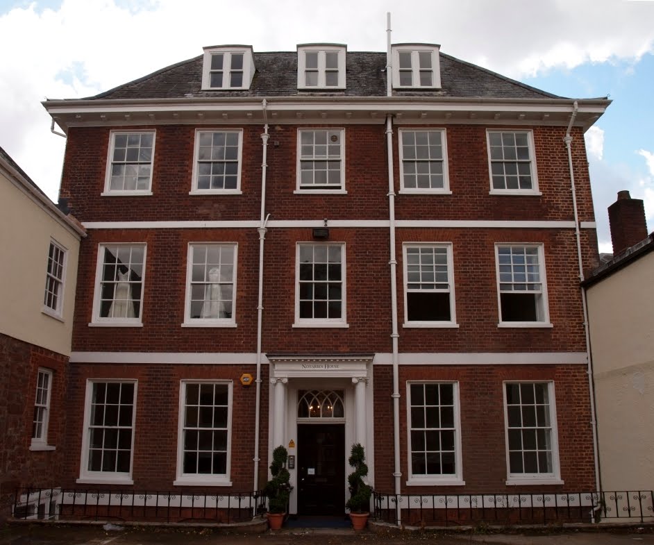
The Notaries' House: No. 8, Cathedral Close

From both a historical and an architectural perspective, the Notaries' House above is an important building. Its history is fascinating and despite some unfortunate modifications its surviving architectural features are of a high quality. The property's story is complex and dates back at least to the first decades of the 15th century.

It stands on the site of what was once part of a group of buildings occupied by members of the cathedral's clergy and which were constructed between c1410 to c1430 around a narrow central courtyard. The west range consisted of a great hall with an exceptional hammer beam roof, known today as the Law Library. There was also an east range, now No. 9a Cathedral Close and a south range, now No. 9 Cathedral Close.

The north range is believed to have contained high status living rooms such as a solar and large bed chambers, and it was upon the site of this north range that the Notaries' House was built in the late-17th century. (Two of the other three medieval ranges from the early 15th century, the south range and the west range, all survive relatively intact. The east range was much-altered in the late-1600s but still contains significant medieval material.)

The aerial photograph right c1930 shows the extent of Nos. 8, 9 and 9a highlighted in red. In the context of the 15th century it would've been a property of enormous size. The Notaries' House lies in the centre of the plot, its main elevation facing north towards the backs of the townhouses of Bedford Circus. At the end of the long garden is a large outbuilding, also highlighted in red, and described on a 19th century plan as comprising "coachhouses with chamber over, stables and hay loft over, and courtlage". Running between Bedford Circus and the stable block is Egypt Lane, later known as Chapel Street. The building to the far right in the photograph, with a three-storey porch, was the Abbot's Lodge, destroyed by a high-explosive bomb in 1942.

Nos. 8, 9 and 9a remained as a single residence throughout most of the 16th and 17th centuries. Following the Reformation in the 1530s the cathedral's Dean and Chapter reduced the number of canons residing in the Cathedral Close, preferring instead to lease their large houses to wealthy members of Exeter's gentry. The extensive property was leased to the Bruton family from at least the end of the 1500s until the 1660s. William Bruton is recorded as having paid two shillings for each of his 14 hearths in the 1662/63 Hearth Tax. Clearly the group of buildings constituted a sizeable house.

In 1668 it was leased again to Christopher Bale, a member of the gentry who had married one of the Brutons and who was later to become both the city's mayor and and its MP. Bale divided the accommodation of the sprawling house, keeping at least part of the south range, the hall range and the north range together, and sub-let it as two separate properties. However, it's almost certain that Bale lived in the house at some point himself as the medieval hall contains both his coat of arms, shown above left, and those of his wife, Margaret Bruton, painted onto shields held by the carved angels that terminate the hammer beams.

The Notaries' House was born from disaster when a major fire broke out in the extensive medieval north range. According to an entry in the Dean and Chapter Act Book from 1692 the "most and the Chiefest part" of the property "was lately burnt down". Fortunately the thick walls of Heavitree stone prevented the fire from spreading to the adjoining ranges.

Bale's lease was extended at a reduced cost as a result of the fire but it was necessary to rebuild the fire-damaged north range. The result of this rebuild was the current Notaries' House, a late-17th century, brick-built mansion in the centre of Exeter and one of the most exceptional buildings of its kind remaining in the city. (A three-storey pavillion, just visible to the left in the photograph top, is now part of the Notaries' House but it was originally the northern end of the medieval east range and so will be discussed in a later post that covers 9a, Cathedral Close.)

Fortunately in 2007 the city council's own Exeter Archaeology Unit (now sadly disbanded as part of city council cost-cutting) carried out an extensive archaeological survey of the building, recording all of the surviving features from different periods. Some of the following information is taken from their detailed report. The Notaries' House was built to a simple plan: five storeys high, including a basement, and only one room deep with two rooms on each floor arranged around a central staircase. It was only intended to act as a wing, an add-on to the surviving medieval ranges at the front. The photograph at the top of this post shows the north-facing elevation of the Notaries' House. This was technically the rear of the property despite it having the visual appearance of the main street facade. The entrance was in fact through the Cathedral Close via an external passageway to the side of the medieval west range.

The aerial view left shows the south side of the Notaries' House almost completely obscured by the earlier medieval ranges against which it was constructed. The building that is attached to the centre of the south wall, projecting at a right-angle, is the medieval west range that contains the tremendous hammer beam roof.

The facade of the Notaries' House is highly deceptive as its current appearance belies the early date of construction. Frustratingly, all of the two-light mullioned windows were altered during a refurbishment in the early 19th century when the current sash windows were installed. Only the basement floor, now hidden below ground level, retains the original late-17th century windows. But much worse was the refacing of almost the entire facade in modern bricks sometime in the post-war period. The mass-produced bricks and the clumsy modern pointing do the building no favours, although at least the exceptionally attractive proportions of the late-Georgian refurbishment remain. (Some of the original brick work can still be seen at the corners of the north facade as well as on most of the south wall.) Stone banding at first and second floor levels divide the five bays horizonatally and beneath the original flared hip roof, into which is set three dormer windows, is a modillion cornice.

In front of the building is a brick-built cellar. This is believed to date to c1800, a century after the rest of the house was constructed. The building of the cellar would've raised the exterior ground level significantly and it's likely that a flight of steps originally led up into the house itself. The current portico, supported on pillars with Ionic capitals, was added in the early-19th century. The lovely fanlight of intertwined Gothic arches was installed at the same time.

Despite its current use as office space the house is stuffed with superb details from the late-17th and 18th centuries. Two internal doorways lead off the entrance hall above right into the ground floor rooms. Baroque doorcases with broken pediments and central pedestals from c1740 still remain within the doorways. These doorcases are rare survivals in Exeter, particularly rare for being of such high quality. The entrance hall also has dado panelling and an ornate box cornice, again from c1740.

The original staircase from c1690 left rises through the full height of the building, from the basement to the top floor, beautifully constructed with a moulded handrail and turned balusters and lit from the windows situated in the central bay of the north wall.

The list of other important surviving features is a long one: a magnificent grey marble fireplace in the dining room from c1740; plaster cornices in both of the downstairs rooms along with the recently rediscovered and significant remnants of bolection-moulded panelling from the late-17th century; large sections of original field panelling in the first-floor rooms as well as extensive cornicing; two more mid-18th century doorcases with broken pediments on the first-floor landing; an early 19th century fireplace, and so on. A blocked doorway on the second floor landing once opened onto a small viewing balcony that looked down into the adjoining medieval hall. (The barley sugar spindles of the balcony are still visible inside the hall). Even the basement has numerous interesting features, such as slate floors and the above-mentioned mullioned windows.

The photograph right is the view east from a small window on the third floor of the Notaries' House. It looks out over the medieval houses of the Archdeacons of Totnes and Barnstaple, over the still-standing 15th century gatehouse of the Abbot's Lodge (the gatehouse was destroyed in 1942 but superbly reconstructed afterwards) and towards the 18th century terraces of Southernhay West, just visible through the trees.

On the far right are the white walls of the former Chancellor's House, remodelled in the early 18th century and now the Exeter Cathedral School. It is all exceptionally lovely, a collection of buildings of such picturesque charm that they have few rivals in the whole of England.

Incidentally, it is called the Notaries' House because it was for a number of generations used by solicitors as their offices, but the site itself is believed to have been the location for part of the timber barracks of the Second Augustan Legion when the Romans built a fortress here in c55 AD. The above-mentioned stable block was damaged during the Blitz of 1942 and half of the garden disappeared under the post-war service road known as Chapel Street. The other half is a car park. The businesses now based in the house use Chapel Street as their address and the main access in and out of the property is now in Chapel Street, although the house is still technically listed as No. 8, Cathedral Close.

It is perhaps unfortunate that the Notaries' House has been converted into offices and retail space but then it's miraculous that it survived the war undamaged. Many of the modern additions necessary for its current use are a distraction but a huge number of historically interesting features do remain, along with much of the general fabric of the early building. Hopefully the building's Grade II* listed status will protect it for future generations. As the archaeological report concludes, "with its fine staircase, panelling, fireplaces and other fittings, the Notaries' House must rank as one of the best-preserved examples of grand town housing of this period in the city".

Sources

Saturday, 10 September 2011

One Thousand Years in Egypt Lane

Despite its obliteration and partial reinstatement in the second half of the 20th century the history of Egypt Lane is both long and interesting! It has probably undergone more name changes than any other street in Exeter but each change says something about the history of the surrounding area.

Egypt Lane was probably first laid out when Alfred the Great refounded Exeter in the late 9th century. It originally ran from its junction with Catherine Street all the way to the city walls near Southernhay. Little is known about the street until the 13th century when it starts popping up in various documents as Strikenstrete (c1265), Strikestrete (1286) and Stykenstrete (1297), and later as Stekeslane (1399) and Styckestreete (1458). It's possible that the name Stick Street or Strike Street was derived from the plural of the Anglo-Saxon word styrc, meaning a young bullock or heffer. By the end of the 13th century the entrance into Strike Street had been barred by the installation of a large wooden gate. 

This seems to have been the result of a liasion between the cathedral's Dean and Chapter, who wanted to improve security within the cathedral precinct following the murder of the precentor William Lechlade in 1283, and the Dominican friars whose large monastic complex had Strike Street as its southern boundary. Anyone walking down Strike Street in the late-1200s would've seen the tall boundary wall of the friary on the left, probably with a postern gate for pedestrian access, and the back walls of the houses and gardens of the cathedral's canons on the right. The street was sandwiched in the middle and presumably closed off at its far end by the 25ft high city wall.

It was necessary for the city authorities to have access into Strike Street so that the interior of the city walls could be inspected and maintained, but the closing of the street theoretically prevented anyone not connected with either the friary or the cathedral from entering the street. The city's mayor also claimed right of access and a document from 1297 confirms that an agreement "concerning a gate in Styke Street" had been reached between the mayor, William Tauntifer and Robert de Ottery, the prior of the Dominican friary, and a right of way was subsequently granted to the city authorities.During the 15th century the street's name gradually changed from Strike Street to Freren Lane, first recorded c1448. (Freren Lane is visible to the far left in Hooker's 16th century plan of the cathedral precinct, shown above left, running parallel with Canon Street or St Martin's Street, as the Cathedral Close was once known. The boundary walls of Russell's Bedford House, inset into which is a little gatehouse, are clearly visible.)

Clearly the name was a reflection of the neighbouring community of Black Friars. They would've been a frequent sight in the area for over three centuries until the friary was dissolved during the Reformation. The street retained its etymological association with the friars of the Dominican order long after the walls of their church had been thrown down and some of the old friary buildings had been converted into Bedford House, the Exeter mansion of John Russell, the 1st Earl of Bedford. The gate at Freren Lane became just one source of a dramatic deterioration in the relationship between the cathedral's Dean and Chapter and the city's mayors in the 1400s.

It's likely that there was an element of what Lega-Weekes called "jealousy of prerogative", with both sides jockeying for a superior position, but in the mid-15th century one of Exeter's most notable mayors, John Shillingford, constantly "compleyneth" about matters arising from access into Freren Lane, described as lying along the "bakside joynant to divers mansions of divers chanons of the clos". In one document Shillingford complains that so much "earth, rubble and dung and other filth" is carried out of the canons' houses and dumped into Freren Lane that it had become almost impassable. In another document he accuses the clergy of having smashed the lock to the gate, replacing it with one for which only they had the key. In yet another surviving document Shillingford demanded that the gate should not be left open except for once-a-year when the mayor went to "over se yf eny nede be to repaire the towne wallys".

The rather naive postcard above from c1900 shows a very rare view into Egypt Lane with St Catherine's Almshouses to the right. Adjacent to the almshouses, on the far right, is the Country House Inn. Formerly a 13th century canon's house, it was destroyed in 1942. 

Another little description of the street survives in a document from 1458 when more problems were caused by rainwater and "other waters" (probably from garderobes and emptied chamber pots) flowing down Catherine Street from the direction of St John's Hospital and pooling at the "head of the lane which leads to the city walls, between the area of the Dominican Convent...and the houses of some of the Canons". The water was creating "a great nuisance by being a receptacle for filth and putrid carcases". The mayor proposed rebuilding the gate at the entrance of Freren Lane, "by which hay and fuel might be brought to the houses of the Canons, who had doors opening into the lane". A drainage channel running via the lane to the city walls and out into the town ditch was to be paid for by the cathedral. Writing in the 16th century, John Hooker describes Freren Lane as running "betwen St Katherens Almeshowses and certen Canons' Howses on the one syde, and the soyle of the late dissolved Howse of the Fryars Preachers, now the Erles of Bedford, on the other syde."

By at least the middle of the 18th century the name had changed again, to Egypt Lane. The origin of this name was a mystery for many years. Hoskins wondered whether it derived from some sort of local slang but it has recently been suggested that it referred to a community of gypsies. Gypsies were once thought to have originated in Egypt (hence the name) and it's perfectly plausible that either some gypsies from Europe or some itinerant workers settled in the area around Freren Lane.

John Rocque's 1744 map of Exeter (shown left with Egypt Lane highlighted in red) clearly shows that by the 1740s part of Egypt Lane, just labelled as Egypt, had been built over with numerous properties and it no longer ran all the way to the city walls. Tenements and other buildings had been constructed on the land once owned by the Dominican friars and on the former grounds of Russell's Bedford House. At least some of the buildings were the stables and coach houses for the New Inn and the Half Moon Inn which fronted onto the High Street (and both of these old inns are labeled on Rocque's map). Another group of buildings belonged to a builder called Mr Brown, as shown on a map of 1819.
 

According to Lega-Weekes, Egypt Lane was also known as Theatre Lane, named after the theatre that opened in 1787 as part of the first phase of the building of Bedford Circus (not to be confused with Waterbeer Street, which was also known as Theatre Lane for a short time); and a deed dating to 1815 refers to Egypt Lane as Johnasses Lane, the only recorded use of such a title. In 1773 Bedford House made way for Robert Stribling's crescent of fourteen red-brick townhouses. The opposite crescent, which completed the architectural circus, wasn't begun until 1825.

The construction of this second crescent resulted in the demolition of most of the existing buildings on the north side of Egypt Lane. The south side retained a jumble of different structures, old stables, etc., most of them still relating to the canons' residences that fronted onto the Cathedral Close. The entire street was once again reopened to its full length, running from Catherine Street, around the backs of the new townhouses and into the eastern entrance of the Circus near the city walls.

The completion of the extra parochial Bedford Chapel in 1832 resulted in yet another change of name and Egypt Lane became Chapel Street, a title which it retained until World War Two. (On John Wood's map of 1840 it is called Church Lane, although the street was still referred to by some as Egypt Lane well into the latter-half of the 19th century.) The building on the north side of the Chapel wasn't constructed as a townhouse, although it looked the same as all the others from the outside. This was the Atheneum, built for the Devon and Exeter Institution and designed as a "Theatre for Scientific and Literary Pursuits and Lectures". There were entrances from Bedford Circus, from a side entrance adjacent to the chapel and from Egypt Lane itself. The map above right shows the Bedford precinct c1900. Chapel Street is highlighted in red, the Atheneum in blue, Bedford Chapel in green and the city walls bordering Southernhay are highlighted in yellow.
 

Bedford Circus was partially damaged by fire in the air-raid of 04 May 1942 and some of the buildings associated with the canons' houses that backed onto Chapel Street was also affected. One of these was a 15th century building with its entrance onto Chapel Street (shown with war damage left). One of its side walls was built from cob, a mixture of mud and straw and a very rare survival in 20th century Exeter. The medieval roof remained intact and although one gable wall had been demolished by a high-explosive bomb the structure was salvageable.

But, this being Exeter, it was totally demolished
as part of the post-war reconstruction, along with the whole of Bedford Circus. After nearly one thousand years of continuous history, Chapel Street, also known as Johnasses Lane, Theatre Lane, Egypt Lane, Freren Lane and Strikenstrete, was redeveloped out of existence. Part of the old gardens of the canons' houses were appropriated for a service road that was built 50ft (15m) to the south of the old street. This service road has been called Chapel Street ever since. The true line of the historic street was covered with single-storey post-war shacks.Between 2005 and 2007 the post-war buildings in Bedford Street were demolished as part of the much-vaunted £225 million Princesshay redevelopment. 

As part of the scheme some lip service was paid to Exeter's past with the reinstatement of a small portion of the original line of Strike Street. Now once again called Egypt Lane it runs for approximately one-fifth of its original length. Little more than a featureless passageway, it is small recompense for the inappropriate designs of the newly-constructed buildings.

Only the ruins of the almshouses at the junction with Catherine Street survive as an indication of Egypt Lane's long and interesting history. The aerial view right shows the service road now known as Chapel Street highlighted in purple. The recently reinstated fragment of Egypt Lane is highlighted in red, a photo of which is shown at the top of this post.

Sources

Wednesday, 7 September 2011

Medieval Merchants at No. 36, North Street

Until the early 1970s North Street was the location of two of Exeter's most important medieval domestic houses, both frequently cited by architectural historians in various periodicals and academic papers. One was No. 38, North Street. The other was No. 36, North Street.

Both houses shared a similar layout and were of a similar age. Both still retained significant remains of their late-15th century origins, including their arch-braced hall roofs, and both were demolished by the city council to build the Guildhall Shopping Centre.

Derek Portman surveyed the building in the early 1960s for his book 'Exeter Houses: 1400-1700' and much of the following information is derived from his account. (Incidentally, Portman wrote detailed reports of about 33 separate buildings in the city which he regarded as the most significant examples of their period. Over 11 of these buildings have since been demolished.)

Stretching back from North Street by approximately 140ft, No. 36 had been added to and altered throughout its nearly 500-year existence but the medieval plan and much of the early fabric remained intact. Like most of Exeter's medieval domestic housing, it was built on a long but narrow strip of land called a burgage plot. The original accommodation probably consisted of a shop, a solar, an open hall, a parlour, a large (bed) chamber, a kitchen and another chamber, and the arrangement of these rooms within the house was of great interest.

The shop with the solar above were built as a single, two-storey block fronting onto North Street. Immediately behind this, and at right angles to the street in order to squeeze it onto the narrow plot, was the hall, open to the roof. Behind this was another two-storey block containing the parlour with a large chamber above. Behind that was a courtyard and behind that was yet another block containing the kitchen with a further room above. Running underneath most of the medieval property was a cellar lined with the red Heavitree breccia used so frequently in Exeter. A through-passage ran down the entire south side of the building giving entry into all of the ground floor rooms and linking the entrance from North Street with the courtyard at the back. The first-floor chamber above the parlour was linked with the chamber above the kitchen via a gallery that sailed out across the courtyard. All of the exterior side walls were built of Heavitree stone and the others were timber-framed. According to Portman, this unusual plan is "repeated, with minor differences, in only one other surviving house in the city, No. 38 North Street".

Whoever built the house in the late-15th century was a citizen, probably a merchant, of significant wealth. Inevitable changes had taken place. The ground floor had been lowered by about 2ft. At the same time the timber-framed facade had been replaced and brought forward by 2ft. According to Portman it was still possible to see traces in the north wall of the jettied first floor as it oversailed North Street. The once open hall had also been divided into two rooms by the insertion of a floor. The kitchen block had been extended c1600 with the addition of two rooms behind it, and in the 1750s yet more accommodation was added behind the kitchen with the construction of another two-storey block containing a drawing room.

The photograph at the top of this post © University of Exeter shows the view towards North Street from a narrow alleyway that ran along the north wall between No. 36 and No. 35. To the right is the gabled end of No. 35, built in the latter-half of the 16th century, with a timber-framed extension at the rear. (No. 35 was demolished at the same time as No. 36.) To the left is No. 36, its open hall, and the window from which it was lit, clearly visible. The map right shows the position and extent of No. 36 c1900.

So what exactly remained of the medieval building at the time of its demolition. The side walls were all intact. The through-passage also remained as well as the cellar. Three chimney-stacks still stood in the north wall. There was a huge, 6ft-wide fireplace from the open hall with a corbelled hood made from purple volcanic trap and moulded jambs with a similar, smaller fireplace in the parlour. A "great splayed window" in the north wall also survived from the hall with smaller windows that once probably lit the staircase. Only part of another fireplace remained in the first-floor solar but, writes Portman, "the one in the principal chamber is well preserved". Also preserved was a section of the wood and plaster partition between the parlour and the hall. Most of the timber-frame and stone walling of the kitchen block also remained, both from the 1400s and the 1500s along with another large fireplace. The first-floor of the kitchen block contained more wood and plaster partitioning as well as its simple late-medieval roof. Panelling and a carved chimney-piece remained in the mid-18th century drawing room.

But "the most imposing feature in the whole building" was the arch-braced roof of the open hall. Three bays spanned the open hall and another two bays spanned the chamber above the parlour, much of which was "still intact". The arch-braces supported the main rafters, making "a continuous arch from wall to wall". Purlins ran parallel with the side walls and between the purlins were wind-braces, the upper set being inverted. Over 22ft high, the open hall had been the physical and social centre of the building and most of the woodwork would've been viewable from the ground floor. A very similar, slightly finer roof existed at No. 38 North Street. (Another similar roof was at the 'Norman House' in Preston Street. Damaged in 1942, the building was totally demolished during the subsequent post-war reconstruction.)

There is little else to add that hasn't already been said in previous posts regarding North Street. Even in the early 1960s No. 36 was empty and in a "dilapidated condition". Despite the rarity of their medieval layout and their importance to Exeter's by then greatly-diminished stock of historically important buildings, No. 36 along with its near twin at No. 38 were both demolished in the early 1970s to build the visually atrocious Guildhall Shopping Centre. It seems incredible that two almost adjacent medieval open halls with intact arch-braced roofs should've simply been torn down as late as the 1970s. No. 36 stood to the right, near the footbridge, in the photograph below.

Sources

Monday, 5 September 2011

A 14th Century House at No. 8, Milk Street

Until its destruction in 1942 No. 8 in Milk Street was one of the oldest surviving domestic buildings in Exeter, despite being much-altered in the intervening centuries. (The so-called 'Norman House' in Preston Street, damaged in 1942 and demolished soon after, probably dated to no earlier than the 15th century).

No. 8, Milk Street is highlighted in red on the 1905 street plan of the city left, overlaid onto a modern aerial view of the same area. The house on Milk Street was built c1320 on a very simple plan. It was only two-storeys high and one room wide, with a cellar beneath. Only half of the cellar was actually below ground and the house was entered via steps from Milk Street. Originally with a timber-framed facade, the other walls were built from the purple volcanic trap quarried at Rougemont.

The main entrance from Milk Street opened directly into the hall with a second room at the rear. Inset into the corner of the hall, within the very thick north wall, was a garderobe which was ventilated by a slit window that looked out into Milk Street. The garderobe would've emptied directly onto the street! There was also an early-14th century fireplace in the hall. The room at the rear had a surviving two-light window and in one of the corners were the remains of a stone spiral staircase which would've led up to the first-floor chambers, one of which also contained a medieval fireplace. A narrow alley at the back of the house gave access into George Street. This alley is highlighted in purple on the image top.

And that's it. Little else is known about the building. It appears to have remained undiscovered until Milk Street and the surrounding area were badly damaged during the Exeter Blitz of 04 May 1942. As the rest of the street burned the tough volcanic rock of the walls of No. 8 remained standing. Fortunately the architectural historian, Arthur Everett, surveyed the building in the aftermath of the bombing raid. (He also recorded the remains of the Anglo-Saxon church revealed by the bombing in nearby George Street.) The walls of No. 8, Milk Street, which predated the ravages of the Black Death, were subsequently demolished as part of the post-war reconstruction and the site is now part of a car park below. No. 8 stood approximately where the sign with the arrow is today.

Sources

Thursday, 1 September 2011

The Law Library: No. 8, Cathedral Close

It’s unlikely that many people in Exeter are even aware of its existence, but hidden behind the half-timbered façade of No. 9 Cathedral Close is one of the most remarkable medieval sights in the southwest of England: the 15th century roof of the Law Library left, almost a copy, in miniature, of the great hammer beam roof at Westminster Hall in London. To find such a thing in Exeter is remarkable.

In the first half of the 15th century, Nos. 8, 9 and 9a Cathedral Close formed a large complex of ecclesiastical buildings constructed around an elongated quadrangle. The exact layout and use of the rooms remains uncertain as the building’s original purpose is unknown, although it is possible to speculate. Based upon current understanding of the building, the front south range probably contained lodging chambers for retainers of relatively high social standing, with the more prestigious chambers in the north range at the rear, now occupied by the Notaries’ House of c1690. The Law Library hall formed the western side of the central courtyard. The eastern range (now 9a Cathedral Close) probably contained the kitchen, buttery, pantry and other service rooms, running parallel to the hall and completing the quadrangular ground plan. Naturally, if the buildings’ function were largely administrative then the arrangement of the rooms would’ve been quite different.

The photograph right was taken from the north tower of the cathedral looking down onto Nos. 8, 9 and 9a in the Cathedral Close. The Law Library is highlighted in red. The 18th century Notaries' House is at the rear. The gateway and passageway leading to the Law Library are to the far left.

The entire complex was probably built for one of the cathedral’s many canons although no consensus exists for precisely whom the buildings were constructed. Both the cathedral’s medieval Chancellor and Treasurer have been suggested as candidates but there had been residences providing for these two offices on the opposite side of the street since at least 1311.

The hall is accessed through a gateway and a flagged external passageway directly off the Cathedral Close. At the entrance into the gateway is a wide four-centred arch. The lintel of the archway is made from Beer stone and inset into the spandrels at each corner is the heraldic device of the office of the cathedral’s Chancellor: four crosslets and a saltire. This would seemingly prove a connection between the hall and the Chancellor but much depends on when the lintel was installed.

The style of this entrance arch left is often referred to as ‘Tudor’ because of its prevalence throughout the 16th century but it was probably first used in England at the chapter house and cloisters of Old St Paul’s cathedral in London in the first half of the 14th century, nearly one hundred years before No. 9 Cathedral Close was constructed.

It's possible that both the arch and its association with the Chancellor of the cathedral are contemporary with the 15th century hall itself. If this was the case then the hall and its associated buildings could’ve been connected to the Diocesan Chancery, an administrative department which oversaw the handling, writing and copying of all of the ecclesiastical documents connected to the Exeter Diocese. The opulent scale of the hall certainly suggests that it was intended to act as a statement of power and status in its own right. As Portman says in his book ‘Exeter Houses 1400-1700’, the “superb quality of the work makes it exceptional and it may well have been unique in the city”.

A recent report by Exeter Archaeology states that the complex was most likely a "canon's residence, with a grand hall for semi-public use and chambers, lodgings and service buildings in the other ranges", although it should be added as a caveat that there is no documentation that proves the matter one way or the other. If it was a canon's residence then the presence of the Chancellor's arms on the doorway remains a mystery.

The hall’s use as a Law Library only dates to the end of the 19th century when the hall was sublet to the Exeter Law Library Society, but it has been known by that title ever since despite the fact that it no longer serves that purpose.

The panelled doors with bolection moulding at the entrance to the gateway almost certainly date to the early 1700s and are contemporary with the reconstruction of the Notaries’ House at the rear. To the right can be seen a now-blocked medieval arched doorway that once led into the front range. The low height of the doorway suggests that at some point the ground level outside was lower than it is now and documentary evidence does exist to indicate that the ground level at this end of the Cathedral Close was raised at the end of the 16th century.

Set into the rear wall of the gateway is a 16th century oriel window and entry into the hall itself is through another four-centred arch off the passageway, similar in style to the arch at the entrance into the gateway. It’s likely that this was the original external entrance into the hall (shown left, from inside the hall). Opposite the entrance, but now hidden behind the plaster, is another arched doorway that originally exited into the small courtyard. The presence of this opposing doorway is an importance piece of evidence for determining the medieval layout of the hall.

It seems likely that there was once a wooden screens passage running across the entire south wall, accessed both from the main entrance off the passageway as well as the blocked doorway opposite. It is a typical arrangement. In medieval halls the screens passage usually provided access to the service rooms. It's not difficult to imagine servants running through the small courtyard and bringing food into the hall from the east range via the now blocked doorway and the screens passage. There are two windows in the eastern wall with a third in the opposite wall, all with three-centred arches. These windows are late-17th century replacements. The jambs are all made from Beer stone except for one surviving medieval jamb of purple volcanic trap in the window opposite the main entrance. The 17th century windows are regarded as some of the finest surviving examples of their date in the entire city.

One of the windows is partially blocked by a partition that was erected in the 1840s when a portion of the hall was requisitioned for a passageway in the Notaries’ House to the north. As one 19th century antiquarian put it, “the fine appearance of the hall has suffered more in proportion than the dwelling-house has benefited”. The partially-blocked window is also the only one with any decorative details, a little flower motif called a 'fleuron' that runs along the top of the arch. This decoration is believed to be a fragment of the original medieval window suggesting that this was the 'high' end of the hall where the property's occupier and his guests would've sat, probably on a raised dais.

On the eastern wall of the hall is a late-17th century fireplace although an examination of the exterior of the wall indicates that this has probably always been the location of the chimney. The south wall is a partition constructed of timber-framing which rises to the full height of the roof and beneath which are sections of late-17th century panelling. The partition separates the hall from the south range. Hidden from view behind the panelling is a now-blocked high-quality decorated Gothic doorway that originally provided access into the hall from the south range.

But everything in the hall pales under the brilliance of the hammer beam roof itself, one of the great glories of medieval Exeter. Dendrochronology carried out by English Heritage has returned a felling date for the oak trees used in its construction as being between 1417 and 1442. It was probably built c1425, along with much of the rest of the complex, during the first years of the reign of Henry VI. Measuring 32ft long with a span of 22ft 9ins and 30ft high, four great arch-braced trusses divide the roof into three bays. Both the arches and the curved braces that support the hammer beams spring from five-sided stone corbels carved with stylised foliage. The two main purlins that run from one end of the hall to the other are themselves supported by more arch-braces that rest on the backs of each angel. The narrower secondary purlins, lower down the roof, are supported by diagonal wind-braces.

One feature of the roof that is highly characteristic of a medieval school of Devon carpentry based around Exeter is the inclusion of a coved apex that runs above the arch-braces at the very top of the roof itself, almost like a barrel fault in miniature. This instantly recognisable feature is something that appears in other surviving medieval hall roofs in the city i.e. at the Guildhall (c1468), the Deanery (c1420), at the Archdeacon’s house in Palace Gate and at the medieval manor house of Bowhill (c1500). Another slightly later example exists at Cadhay House, about 11 miles from Exeter. (The Cadhay roof was originally a hammer beam structure too, very similar to the Law Library, but the hammer beams were cut off in the 1730s!)

The Law Library roof has been almost untouched since the 15th century, and the richness of the decoration is astonishing. Nothing else in the city is comparable apart from the vault of the cathedral itself. Nearly all of the main timbers are heavily moulded. The eight horizontal hammer beams terminate in carved angels. The two angels at each end of the roof carry books and are turned slightly inwards, the others clutch shields painted with heraldic devices. The angels aren't merely decorative additions as each hammer beam was carved from a single piece of wood. It is also believed that the beams now hidden beneath the current plaster ceiling were originally exposed to view.

One strange feature is at the south end of the roof into which is set what looks like a small hexagonal louvre or smoke hole. It might once have been the site of a lantern for letting in more light rather than an exit for smoke. Its presence led 19th century antiquarians into speculating that the hall was once longer than it is now and that the louvre was originally in the centre of the hall but this is highly unlikely. All the evidence, including the inward-looking hammer beam angels against the walls, the lack of seriously smoke-blackened timbers and the survival of 15th century features in the south range, suggests that the hall has always been its current size.

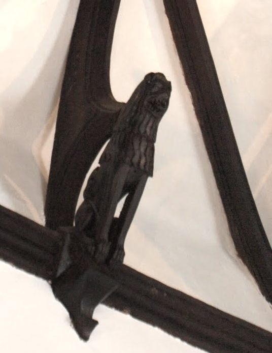
At the base of the rafters are huge attenuated lions sejant, magnificently carved from solid oak and sculpted almost completely in the round. The lions to the west snarl at their more benign counterparts opposite, one of which has its tongue stuck out in reply (one of the aggressive lions is shown below left). Their manes trickling in rivulets down onto their shoulders, these lions are beautiful and one of the highlights of the entire roof.

There are thirteen carved bosses at the intersection of the ribs and the wind-braces. Seven of these bosses run in a line along the very top of the roof. From the south wall to the north wall they depict: an abstract pattern; a face hidden in foliage; a male face; two male faces joined at the cheek; an angel holding a ribbon on which is a shortened version of the Latin phrase “Non nobis Domine non nobis” (‘Not to us, Lord, not to us’) from the 115th Psalm; the head of Christ; and finally a black eagle carrying a ribbon in its beak inscribed with the Latin phrase “Comes Virtutis” (‘Virtue is a companion’).

The remaining six bosses cover the join between the secondary purlin, the wind-braces and the rafters. There are two in each bay. The bosses on the western side of the hall, where the main entrance is located, depict: a green man with his tongue stuck out, his beard and moustache made from foliage; a face hidden amongst hawthorn leaves; and another green man enveloped in vine leaves. The bosses on the opposite side of the roof depict: a rose surrounded by foliage; yet another green man peering out from hawthorn leaves; and a woman’s head, the only female representation in the entire hall.

And the abundance of medieval art continues as the top of each rafter is surmounted with a carved head. Starting above the entrance and moving clockwise: there is a man with a tall flat-topped circular hat with a cross on the front; a king with a flowing beard wearing a crown; another man wearing a pointed hat with a little ball on top; a man with no hat but with a long, flowing beard; a bishop with long hair but no beard wearing a mitre, and another male head wearing a peculiar hat which looks like a nightcap but which is probably a Phrygian cap, often used in medieval art to signify a Jew. As if all of that wasn’t enough then the spaces between the hammer beams and the arch-braces are filled with wonderful Perpendicular Gothic tracery, again all carved from oak. When new every surface would’ve been brightly painted. Everything is of the highest quality.

The Notaries’ House, which forms the rear range of the quadrangular layout, was rebuilt in brick c1700. It was at this time that a vantage point was formed high up in the roof that provided a view down into the hall itself. This is now blocked although a section of balustrade remains near the apex on the north wall. The heraldry depicted on the shields carried by the angels was also executed at this time when the hall underwent a major refurbishment. The coats of arms on the shields appear to be those of local families who were prominent towards the end of the 17th century.

Immediately above the main entrance is the coat of arms of the local Bale family: three stars divided by a bar against what was originally a silver background, an allusion to Christopher Bale who was the MP for Exeter from 1689 until 1695. Christopher Bale also occupied the property from 1668 and it was probably under his instigation that the rear buildings were reconstructed in brick c1692 following a major fire.

Adjacent to this are the arms of the Exeter Smyths, three gold birds (or martlets) divided by a bar against a black background. This is a possible reference to Sir James Smyth, MP for Exeter from 1661 to 1679. On the opposite angel's shield is the coat of arms of the Brutons of Heavitree, a silver bar and two chevrons against a red and blue background (shown above right). A William Bruton, Esq. died in 1608 and was buried in the cathedral but one of his granddaughters, Margaret Bruton, married Christopher Bale c1659. The Bruton family also occupied the property in the 16th and 17th century before it was leased to Christopher Bale in 1668. Margaret Bruton died in 1675 so it seems likely that the shields were painted between c1660 and 1675. Another William Brewton was a ‘notary public’ in the 1580s and a John de Brueton was a Chancellor of the cathedral in 1307.

On the shield opposite the main entrance door is the coat of arms of the Stawell family left, a cross made of lozenges against a red background. The inclusion of Stawell is perhaps in remembrance of Sir John Stawell, a former High Sheriff of Somerset and Royalist soldier who was captured by General Fairfax in Exeter in 1646 when the city fell during the English Civil War. He refused to swear not to bear arms against Parliament and spent the entire Commonwealth period imprisoned in the Tower of London.

It’s impossible to write about the hall without commenting on its similarity to the tremendous hammer beam roof at Westminster Hall below right which undoubtedly served as its model. The immense Westminster roof, designed for Richard II by Hugh Herland, was finished at the end of the 14th century and became one of the wonders of medieval Europe. Perhaps someone from the cathedral’s chapter simply saw the roof at Westminster Hall within a few decades of its completion and decided to imitate it at Exeter.

Apart from its hammer beam form, the decorative resemblances are striking: the Gothic tracery above the hammer beams and the carved angel terminals are clear inspirations, but there is also a more general affinity of style that is unmistakeable.

There are also clear structural differences, as if someone sketched or memorised the hall in London and then presented a rough plan to the Exeter carpenters who set about recreating it using their own individual, localised techniques. And surely that was the whole idea. The spectacle of a piece of medieval London was seen and carried to Exeter as an idea. The mechanics of how to construct it were secondary compared with the vision that its medieval creator wanted to convey. It was perhaps the impression of Westminster Hall that was the impetus, not the actual technicalities of the roof itself.

The roof, and the Cathedral Close in general, came within metres of total destruction during the bombing raids of 1942 and the city nearly lost one of its greatest treasures. Fortunately the hall survived unscathed but for many years it remained closed to public view, divided by temporary partitions and cluttered up with filing cabinets and boxes. It was only possible to glimpse the roof itself through one of the hall windows. The hall came onto the market several years ago and it was purchased by a private buyer. It has recently been let to SustainCare, a social enterprise company who specialise in self care approaches within local communities. Fortunately the new tenants have generously decided to open the hall to the public! The hall is now open from 12 noon until 2pm on Monday, Tuesday, Wednesday and Friday of each week, which is a very welcome development. It must be seen in person as my photographs fail to do it justice.

The hall is a Grade I listed structure and a Scheduled Ancient Monument of national importance. It is described in a recent archaeological report as "one of the outstanding structures of its kind in the country", and hopefully it will now receive the wider attention that it so fully deserves.

Sources

Saturday, 27 August 2011

No. 15, Frog Street

Despite its small size and apparent insignificance, No. 15 in Frog Street left was one of the Exeter's historically interesting buildings, a lone survivor and a unique example of its type.

Situated just beyond the city walls and the West Gate, and on the edge of the industrial area known as Exe Island, Frog Street had largely retained its medieval appearance late into the 19th century, with gable-ended, timber-framed houses from the 1400s and 1500s lining both sides of the narrow route, their upper floors oversailing the street below.

The street's picturesque character was gradually eroded through sporadic demolitions in the first three decades of the 20th century until, in 1961, just two of the street's historical properties remained. One stood on the corner of Frog Street and Edmund Street. A small mid-15th century merchant's house, it was salvaged and gained some local fame as "The House that Moved" when it was transported on wheels into a new location on West Street. No. 15 Frog Street wasn't so fortunate.

What made it a unique survivor was its layout. Unlike the other timber-framed houses that survived in Exeter into the 1960s, No. 15 was built with its roof parallel with the street. Derek Portman in his book 'Exeter Houses 1400-1700' suggests a plausible explanation for why this layout was less commonly seen in the city centre. The importance of having street frontage in the commercial centre of Exeter was paramount. It was therefore customary to have long, thin plots of land (burgage plots) at right angles to the street with narrow shop fronts, thereby maximising the number of properties that could be built on any given thoroughfare.

Frog Street's location beyond the city walls meant that there was simply more space to build and so wider street frontages were both possible and desirable. According to Portman "only one building of this kind, No. 15 Frog Street, remained to be surveyed". The photograph right shows the entrance into Frog Street from Edmund Street c1940 with No. 15 highlighted in red. The white timber-framed property on the right, demolished c1950, appears to have had a similar layout to No. 15.

No. 15 was built c1570 and was typical of the sort of house occupied perhaps by a successful late-Elizabethan tradesman. It was timber-framed and was built on two floors with stone party walls at either end (although at some point the western wall had been rebuilt in brick). Access into the property was originally through a side passageway that ran underneath the first floor and out into a courtyard at the rear. Entry into the house itself was via a doorway in this passageway. On the ground floor was a single large room with a fireplace in the eastern wall. The first floor was divided into two rooms by a studded partition which, according to Portman, was "completely preserved and visible". The 16th century roof structure had also survived with little alteration. The property had been extended at the back, probably in the late 18th century, but the overall plan of the Tudor building was "easily discernible".

Unfortunately Frog Street was in the firing line of the council's inner bypass road system, first proposed by Thomas Sharp in 1945. As the bypass edged its way towards the river in the late 1950s and 1960s dozens of historical properties were demolished, including a large number of mid-17th century houses at the Southgate, the city's earliest brick-built house on Magdalen Street and Dr Dicker's early-18th century mansion. No. 16 Edmund Street was saved from destruction and moved, but No. 15 Frog Street was to have no such reprieve and in the summer of 1961 it was torn down.

Sources
Related Posts Plugin for WordPress, Blogger...