

It soon becomes obvious that Holloway Street falls away from the high plateau upon which Exeter was built before rising steeply as Holloway Street turns into Topsham Road. The pronounced dip in the road is the valley, or hollow way, that gave the street its name. Although Roman in origin, the road was called Carterne Street by 1291 (according to Hoskins this refers to the place where the carters lived). By the 15th century Carterne Street had changed to 'Holoway' and the name has stuck for the last six centuries.

The Shitbrook rose close to St Ann's Chapel at the top of Sidwell Street and flowed along the south side of the city, behind Denmark Road and down through the steep-sided Shitbrook Valley before discharging into the River Exe, downstream of the city itself. It is this valley which is still visible in the dipping and rising topography of Holloway Street.
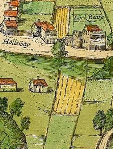
The photograph above right shows Holloway Street as it crosses the site of the Shitbrook. The stream bed would've been around 5 metres beneath the present road surface in the Roman and medieval period, which show how much the hollow way has been filled in. Despite the reduction in the gradient it's stilll possible to see how the street rises up and curves towards Topsham Road on the opposite side of the valley. The remaining fragment of Old Larkbeare House is on the left. Larkbeare Bridge lies 2.5 metres beneath the road surface just beyond the pedestrian crossing with a pushchair.
The Shitbrook, more politely known today as the Shutebrook, still runs beneath the road. It was covered over in the 1840s and turned into a storm sewer and it probably wasn't quite as noxious as its name suggests. The steep fall of the brook from its source to the Exe probably meant that it was kept relatively clean in all but the driest months (which, in Devon, don't occur that frequently!). By 1467 the city chamber had built public latrines outside the city which emptied into one of the mill leats of Exe Island. This must've alleviated the amount of waste carried by the Shitbrook to some extent. (Larger properties in the city centre would've had garderobes that discharged into cesspits which could be emptied at regular intervals.)
 The Romans might've built a timber bridge to cross the Shitbrook at the bottom of Holloway Street as it would've flowed with some force after heavy rains. No evidence of this remains but, remarkably, a Scheduled Ancient Monument does survive some 2.5 metres beneath the modern road surface. This is Larkbeare Bridge, one of the earliest surviving medieval bridges in southwest England left © Devon Archaeological Society.
The bridge was built in the 13th century so traffic could cross the Shitbrook and is probably contemporary with the great medieval Exe Bridge completed in the early 1200s. English Heritage have described the structure as a "remarkable and rare example of medieval engineering". When the Shitbrook was covered over in the 1840s the bridge was completely buried instead of being removed and so the stream still flows under its arches just as it has done for 800 years. No sign of the bridge is visible from above ground. In February 2013 work had to be carried out on the bridge after a collapsed sewer pipe was found to have damaged some of the mortar holding the stones together. Much of the work on the sewer pipe had to be done by hand to prevent vibrations from machinery damaging the ancient structure.
The earliest reference to Larkbeare is from a deed dated to the first half of the 13th century. The document refers to the brook next to "the land of Richard de Leverbeare". There was almost certainly a significant house on the site by then. The estate is referred to again c1266 when it is in the possession of Adam de Laverkbere to whom it had descended. By the 15th century the estate had passed from the Larkbeares to Nicholas Bowden. In 1416 Bowden was granted a licence by Bishop Stafford to have divine service performed for a year in "his mansion at Lerkebeare in the parish of St Leonard's". The Bowdens didn't have the estate for long and by the end of the 15th century it belonged to a family called Hull.

Built of the local red Heavitree breccia, the house had three storeys, a cellar and at least one garderobe that emptied directly into the Shitbrook. A 16th century wooden garderobe seat from the house survives and is in the Royal Albert Memorial Museum in Exeter. The principal chambers had a series of elaborate oak coffered ceilings made from intersecting, richly-moulded beams.
By 1617 the property had been sold to Sir Nicholas Smith and by 1714 it belonged to an Exeter merchant called Andrew Lavington. Lavington's financial position was precarious and he eventually became bankrupt. In 1716 part of the house was being let by Lavington as a separate tenement. A notice in the Exeter Flying Post of that year states that the tenement is "the Fore Part of Larkbear House, without South Gate, Exon, containing a Kitchen with a little Room by, a large Parlour and a Cellar, with a Chamber over the Cellar; also 5 Lodging Chambers with 3 Closets; likewise a Garden; being very fit for a private family".

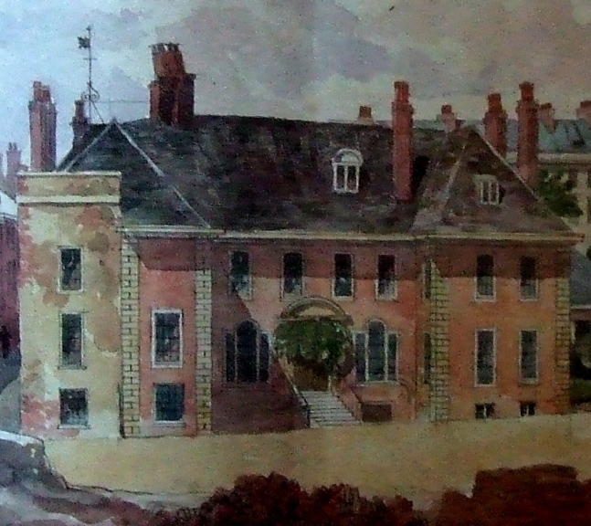
It was the Baring family who made extensive alterations to Larksbeare House c1740. The medieval core was retained but the property was extended and the exterior remodelled. A handsome 8-bay classical facade was added with two slightly projecting wings at either end. The image above right shows a watercolour of the northern end wall of the remodelled property c1850. The image below left shows a similar watercolour depicting the facade of Larkbeare House following the mid 18th century alterations. Holloway Street can just be seen on the left. The mid 19th century townhouses of Lansdowne Terrace are in the background on the right. Both images are © Devon County Council.
This remnant of old Larkbeare House is now No. 38 Holloway Street and is Grade II listed. From the outside the house appears to contain little of interest but the ground floor still has a remarkable oak coffered ceiling from what was perhaps the parlour of the great 16th century mansion. There is also a large three-bay room on the second floor which has retained its fine arch-braced roof. It's difficult to know what else remained of the 16th century house when the property was largely demolished. But it's clear that, at the very least, Exeter lost an attractive Georgian mansion close to the city walls.


The photo above left shows the facade of No. 38 Holloway Street today following some brick additions made at the end of the 19th century. It's hard to believe it's the same building as that is shown in the mid 19th century watercolours. The image below shows what old Larkbeare House would might look like from Holloway Street had it not been demolished in 1889.

1 comment:
The part of Larkbeare House on the corner of Holloway Street and Roberts Road was a paper shop and tobacconist up until, at least
1964. I lived in Roberts Road then and did a paper round for the shop.
Post a Comment