Saturday 30 March 2013

St Edmund's Church, Exe Bridge

St Edmund's Church is, or was, another of the city's ancient parish churches. It is shown above in a very rare photograph from the 1860s, the dark stone church contrasting with late 17th century timber-framed houses that cluster around it. St Edmund's, or St Edmund on the Bridge, actually stood on the medieval Exe Bridge, as did the timber-framed houses, their sagging galleries and upper floors supported by a network of wooden timbers springing out from the stone arches of the bridge itself.

Like Holy Trinity and St Mary Major, the medieval fabric of St Edmund's suffered from almost complete reconstruction during the 19th century. Apart from portions of the tower, the church in the photograph only dated to the 1833 but the origins of the church were much older. There is some uncertainty about the date of the first church. According to David Francis, the first church on the site "was probably a very small chapel taken down when the first stone Exe Bridge was built c.1200". Cresswell believed the chapel was late Saxon in origin. Unfortunately there's no archaeological evidence to support such an early structure. A 'chaplain of the bridge' is mentioned in 1196, soon after construction of the bridge had started, and it's possible that this chaplain was associated with St Edmund's.

A chapel on the bridge dedicated to St Edmund was definitely in existence by c1200 as it is mentioned in the will of Peter de Palerna. If there was an earlier structure on the site then it would've been demolished and rebuilt when the new bridge was built. The chapel of St Edmund didn't become a parish church until 1222.

The image right shows a modern aerial view of the church overlaid onto which is the 1905 street plan of the city: remains of St Edmund's (1), the remains of the medieval Exe Bridge (2), the site of the lower leat (3), the site of the higher leat (4), the site of the West Gate (5), the original location of The House That Moved (6), the so-called 'Tudor House' in Tudor Street (7). The houses, factories and warehouses highlighted in red were demolished when the inner bypass was created in the 1960s and 1970s.

The great stone bridge that spanned the Exe, approximately 750ft long, was begun c1190 and probably took 40 or 50 years to complete. By the end of the 13th century there were three religious sites on it. A chantry chapel dedicated to St Mary, which stood opposite St Edmund's, and a chapel dedicated to St Thomas at the far (western) end of the bridge. St Edmund's stood at the eastern end, outside the city walls and close to the West Gate. It was built parallel with the bridge across two of the bridge's arches. The fabric of the church was supported underneath by stone pillars to allow water to pass underneath the church and through the spans of the bridge. (The place where the bridge started at its eastern end was more marsh than fast flowing river, at least for most of the year, the Exe being much wider and shallower then than it is today).

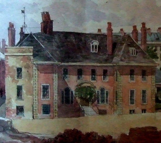
The drawing left shows St Edmund's Church in the 1830s before it was reconstructed. It looks like a normal street but it is in fact the carriageway of the medieval Exe Bridge with houses built on either side over the arches of the bridge. The two gabled houses next to the church tower are the street frontages of the two gabled houses that can be seen next to the church in the photograph at the top of this post.

The 13th century church was possibly a simple single-celled structure constructed from the same purple volcanic trap as the bridge itself. It underwent a series of alterations in the following centuries. The bell tower was added between 1448-1449 when Bishop Lacy was offering indulgences to anyone who would contribute towards the cost of a new belfry and a side aisle was added c1500. Fortunately a brief description of the late medieval church was made just after it had been almost completely demolished. The description appeared in an article in 'The Gentleman Magazine' in 1835: "The exterior, as far as could be seen, was built of red sandstone so common in the buildings of Exeter. The mullions and arches of the windows and doors, were executed in freestone, forming a pleasing variety. The doorcases and the two windows in the Church, with the lower one in the tower, are of the latter part of the fifteenth century. The square windows and door towards the east, are not earlier than the reign of Elizabeth. This portion of the structure may have been the residence of a chantry priest at a prior period. The interior consisted of a nave and side-aisle, divided by arches, either circular or very obscurely pointed, the columns octagonal, with moulded caps". The "red sandstone" was probably Heavitree breccia, a relatively poor quality stone used in Exeter from the 1350s onwards.


 The drawing above was executed by the author of the article. It was, he said, "taken from an opposite window on 1st August 1830, at which time the demolition of the Church was talked about. A crack was visible in the north wall; but probably the fondness for improvement which has led to the rebuilding of several of the churches in the city, was the actual cause of its demolition. The protecting Genius of the Church would exclaim 'repair,' but 'not destroy;' but this small still voice would be drowned in the yells of the Demon of Improvement". It was ever thus.

Alexander Jenkins fills in a couple more details relating to the post-1833 church in his brief description of 1806: "The tower is small and not very lofty. It is crowned with a small spire and vane; it has six bells, which from their situation near the river have a very pleasing sound". Jenkins also mentions some remnants of painted glass in the windows that featured the heraldic shields of various Devon families.

The photo right shows two of the remaining medieval pillars which once supported the floor of St Edmund's Church allowing water to flow under the church and through the bridge arch on the right.

The church was not only one of the four retained in Exeter during the Commonwealth that followed the English Civil War but it might've been the location for the city's first printing press. A printing press is known to have existed at Tavistock Abbey prior to the Reformation. After the abbey was dissolved in 1539 the press disappears. But in a will of 1567 the rector of St Edmund's, John Williams, cites "all such stuff as tooles concerning my printing with the matrice with the rest of the tooles concerning my press". It's probable that the rector was related in some way to William Williams, a known monk at Tavistock Abbey and that the press mentioned in 1567 was once at Tavistock Abbey.

On the morning of 19 August 1800 there was a tremendous thunderstorm over the city that raged for five or six hours. The church was struck by lightning, much to the excitement of the population. The "dial of the clock was beaten to pieces, the machinery of the chimes was deranged, the wire attached to it melted or burnt to small pieces, and scare any part of the church escaped injury". The sulphurous atmosphere left in the church after the strike made it difficult for the sexton to remain long in the building. The lightning conductor attached to the weathervane was blamed for carrying the lightning into the church itself.

By 1830 the church's future was in doubt. A report in the 'Exeter Flying Post' on 25 February announced that divine service had been suspended because of the "insecure state of St Edmund's Church".

A meeting of the parishioners had been called by the rector "to consider the best means for reinstating it by a new edifice". On Thursday 06 September 1832 the 'Post' claimed that "the demolition of the Church of St Edmund on the Bridge in this city...was commenced on Monday morning". The same paper announced on 25 July 1833 that "We notice with much satisfaction the progress towards a finish of the New Church of St Edmund's on the Bridge - to that part of our city it will be a great ornament". If only.

Beatrix Cresswell in her 1908 book on Exeter's parish churches stated that "the present building had the misfortune to be erected in 1833, therefore, as a building, there is nothing more to be said for it". Perhaps that's a little unkind. I think the almost contemporary rebuilding of Holy Trinity resulted in a much poorer structure. At least the rebuilt St Edmund's above left had the look of Exeter's other remaining medieval parish churches, even if it had been stripped of nearly all of its historical fabric.


The postcard view above shows St Edmund's Church as it appeared at the beginning of the 20th century looking towards the city (the tower of St Mary Steps can just be seen amongst the rooftops in the background). The cityscape here remained little changed until the 1960s. With the creation of the new Exe Bridge in the 1770s part of the medieval bridge continued to be used as Edmund Street. The bridge was widened in 1854. The work involved in widening it can be seen in the stonework at the bottom of the photograph. This was all removed when the bridge was excavated in the 1960s, returning the structure back to its medieval form.

The aerial photograph below from c1930 shows part of the West Quarter and the leats of Exe Island. The Custom House is bottom right. St Edmund's Church is highlighted in red. Almost none of the buildings shown now survive. Many were swept away as part of slum clearances in the 1930s but the majority were demolished in the 1960s and 1970s during the creation of the inner bypass. The area today is completely unrecognisable. Similar devastation occurred outside the South Gate.

The new church was designed by the local architects of Cornish & Julian (Robert Cornish was also responsible for the Holy Trinity rebuild). A lot of the medieval material was recycled into the rebuilt structure. According to Cresswell, the tower was "in some measure retained, the top repaired with an ornamental parapet".  The galleries that extended down the sides of the old church were replaced with a single gallery at the west end. The old painted glass mentioned by Jenkins was gathered into the windows of the north wall.

According to Cresswell the old font had been left in a stone mason's yard and the one in the church was modern i.e. from the 1830s. The pulpit was fashioned from the 15th century remains of its predecessor. Cresswell also claimed that some "old and rather uncomfortable looking open benches" had been brought from the cathedral at the time of the restoration i.e. in the 1870s.

There were eight bells in the tower which, said Cresswell, "had a very pleasant tone". The old church had three bells in 1533 and five when it was demolished in 1832. The oldest bell that Cresswell saw was dated 1721 with four others dated 1731. Three others dated to 1833 and were installed when the church was rebuilt.

In 1881 the issue of how much of the medieval tower had been left standing resulted in some bickering between the rector of St Edmund's and the city council. In that year the late 17th century houses shown adjacent to the church tower in the photograph at the top of this post were demolished by the city council as part of a slum clearance. The rector wanted to know why the council wasn't prepared to pay for the repairs necessary to the wall of the tower where the house nearest to the tower once stood. He cited a precedent. In 1879 the city council had demolished No. 210 High Street, an early 17th century house that was next to Allhallows Church in Goldsmith Street, and had paid for repairs on the church's newly-exposed wall.

But the council were having none of it and informed the rector that "whereas in the case of Allhallows the house was built against the church, in St Edmund's the church was built against the house". The rector responded with a letter from the churchwardens which stated that "it was obvious that the original wall of the old church was not disturbed when the present church was built (some fifty years since) from the fact that the walls of the old houses still adhered to the west end, the reason doubtless being that to remove the wall would endanger the safety of the premises". The churchwardens also complained that two large beams that had supported the timber-framed houses had been left in the west wall of the church. The churchwardens were undoubtedly correct but it appears that the parishioners ended up paying for the repair work themselves.

The photograph above left shows the surviving west wall of the tower that was at the centre of the disagreement in 1881. Constructed largely from red Heavitree breccia with some random blocks of purple volcanic trap, it is almost certainly a surviving fragment from the medieval church of St Edmund. The remaining part of the tower's south wall, shown above right with the entrance doorway, dates to the rebuilding of 1833. The photo below shows the Edwardian Exe Bridge c1910 looking towards New Bridge Street and the city centre. New Bridge Street was created at the end of the 18th century and bypassed the route into Exeter from the west along the medieval Exe Bridge. The isolated tower of St Edmund's Church is visible to the right.

The church probably started to go downhill after the Georgian Exe Bridge was opened in the 1770s, although Jenkins claimed in 1806 that "the whole of the decorations and furniture in this small edifice is kept in perfect repair". It was effectively sidelined as New Bridge Street made for a much easier entry into the city from the west, and St Edmund's was always one of Exeter's smaller medieval parishes even before the new bridge was built. The church was last used for regular services in 1956 and was then partially damaged by fire in 1969. Although the damage wasn't irreparable, the construction of the inner bypass and the consequent demolition of almost every surrounding building resulted in St Edmund's own demolition in 1973 after nearly 800 years of use as a site of worship. What was believed to be the surviving portions of the medieval building were retained and left as a 'picturesque' ruin along with the remains of the old Exe Bridge now "incongruously sited on a roundabout" (Pevsner & Cherry).


Sources

Thursday 28 March 2013

The Medieval Exe Bridge

The remains of the medieval bridge that once spanned the river Exe at Exeter is one of the earliest structures of its kind in England above. Eight and a half arches out of a likely total of 17 or 18 still survive today, although the ninth arch is mostly buried under the modern ring road. Along with the cathedral, castle and the city walls, the medieval Exe Bridge is one of Exeter's major monuments of the Middle Ages. It's likely that there was a wooden Roman bridge spanning the river at the important civitas of Isca Dumnoniorum. It's now believed that Roman influence extended much further west of Exeter than had previously been thought. Excavations in 2011 at Ipplepen, 16 miles west of Exeter, revealed a previously unknown large Romano-British settlement made up of roundhouses and the remains of a Roman road. This settlement was populated by the native Britons who probably traded with the newly-arrived Romans following the establishment of the fortress at Exeter c55 AD. At least one Roman road left Exeter to the west: a section of the modern A380 towards Newton Abbot is based on a known Roman route and there is some evidence of Roman tin-mining in Cornwall.

Anyway, work on the medieval stone bridge was probably in progress by 1190, although the first documentary reference to it is in 1196. John Hooker, writing in the mid 16th century, believed that this stone bridge replaced an earlier pedestrian bridge made of wood: "there was no stone bridge over the river of Exe, but only certain clappers of timber which served for men to pass over on foot". Hooker goes on to describe the perils associated with trying to cross the river: "in the winter the passage was very dangerous and thereby many people perished and were carried away with the floods and drowned".

The river at Exeter has changed so much over the last thousand years that it's difficult to imagine what it was like in the 12th century but it was once much wider and much shallower than it is today with marshes on either side. It was also a tidal river and at certain times of the day in summer the decreased flow of the water would've exposed glistening mudflats. (The effect of the tides on the river at Exeter were largely eliminated following the building of the Countess Weir of 1296.) The dangers described by Hooker probably came from trying to ford the river in carts and on horseback as well as the frequent destruction of the wooden footbridge by violent winter floods. It was still possible to ford the river as late as the 17th century. A 1662 drawing of the medieval Exe Bridge by Willem Schellinks (illustrated in Hoskins' 'Two Thousand Years in Exeter') shows mounted figures picking their way through the water against a backdrop of the old stone bridge.

The difficulty in crossing the river was noticed by two of Exeter's citizens: Nicholas Gervase and his son, Walter. Despite their own personal wealth, the Gervase family were unable to fund the building of the bridge themselves. Instead Walter Gervase went on a tour of England collecting money for the project from anyone who was willing to donate while his father remained in Exeter to oversee the initial construction. Gradually the bridge was built, arch by arch, as finances allowed. According to Hooker, Walter Gervase raised £10,000, enough both to complete the bridge and to purchase land for its endowment. The aerial view above left shows the remains of the old bridge. The conjectural location of the now missing sections, based on a plan by John Steane, is highlighted in red. The medieval sites are numbered as follows: St Thomas's Church (1), St Edmund's Church (2), St Mary's Chantry Chapel (3), the West Gate (4), Stepcote Hill (5). The perimeter of the city wall is highlighted in purple.

The construction of the stone bridge probably took about 50 years to complete with work ending c1238. It was an enormous structure, approximately 750ft (229m) in length and must've been a wonder to everyone who saw it in the 13th century.

By the time it had been completed the bridge had three chapels. On the city side was the church of St Edmund and, almost opposite, a chantry chapel dedicated to St Mary. On the far side was a church dedicated to St Thomas. Nicholas Gervase, the father, died before the bridge was complete and he was reputedly buried in St Edmund's church. When Walter Gervase died in 1256 he was allegedly buried at the chantry on the bridge dedicated to St Mary. (According to George Oliver, when the chantry chapel was demolished in July 1833 the workmen discovered a tall skeleton under the floor which was then reinterred on the site.)

In reality both Nicholas Gervase and his son Walter were probably buried in the Cathedral Close, as stipulated in Walter's will of 1257. There were also two official positions connected with the bridge. One was the Chaplain of the Bridge, first mentioned in 1196. The chaplain probably officiated at St Edmund's church, which had been located near the eastern end of the bridge since at least 1214. The second was the Warden of the Bridge. The warden administered the various endowments of land and property associated with the bridge. His bronze seal matrix, bearing an impression of the bridge and the latin inscription 'S'Pontis Exe Civtatis Exoniae' ('Seal of the Exe Bridge of the City of Exeter'), still survives and is on display in the city museum, above right. A mid 13th century document is the earliest to survive still bearing a wax impression of the seal.

No-one knows exactly where the bridge started and finished, but on the city side at least it almost certainly began outside the West Gate, the main entrance into medieval Exeter from the west. Cowick Street, on the west side of the river, was on the same alignment as the medieval bridge (although this alignment is difficult to make out following the alterations to the street plan in the 18th and 20th centuries).

Anyone crossing the bridge after its completion would've passed through the West Gate and up Stepcote Hill into the city centre. Hogenberg's 1587 plan of the city, based on a drawing by John Hooker, shows the Exe Bridge in some detail, left. In reality the bridge had more arches than is shown but St Edmund's church is visible towards the West Gate, as is Frog Street. The plan also shows the recesses in the bridge used by pedestrians to keep out of the way of carts. Various mills and leats can also seen. The mills were used for fulling cloth, upon which much of Exeter's medieval and early post-medieval wealth was based.

The image below is a drawing of the medieval Exe Bridge by the early 19th century historian Alexander Jenkins. It shows the houses that were built on the arches at either end of the bridge. The six arches in the centre remained clear of buildings and never seem to have had any structures on them. The little turret on the right marks the bell tower of St Edmund's church. Jenkins' 1806 description of the bridge states that in the centre of the bridge "was a doorway, and a flight of steps, that led to a long vaulted room, commonly called the Pixhay, or Fairy House." There was also a weir made of wattle, visible in the foreground, which Jenkins said was designed to "prevent the fall of water from injuring the foundation". The Pixie House, built into the central cutwater, was probably a public latrine which emptied directly into the river.

There appear to have been efforts made to reclaim some of the swampy ground outside the city walls to the west just before or just after the bridge was completed. With the creation of the bridge, and limited space within the city walls, what was once waste ground would've suddenly gained economic importance. One example of this reclamation was Frog Street (now demolished) which ran between the West Gate and St Edmund's church. Archaeological excavations at Frog Street have recovered large bits of domestic pottery dated to c1230, contemporary with the construction of the bridge itself. This process of land reclamation was to continue throughout the Middle Ages resulting in the creation of the industrial area known as Exe Island. As more land was reclaimed the River Exe was gradually shunted into a narrower channel and eventually attained its present course.

 The 1727 drawing right is by the antiquarian William Stukeley. It shows the view across the river from the suburb of St Thomas to St Edmund's Church. The church's bell tower is visible at the far end of the bridge.

Almost from the moment of its construction the bridge was subjected to numerous floods. According to Jenkins, in 1286 "the summer proved very wet; which caused great inundations; a considerable part of Exe-Bridge was carried away by the high waters".

The bridge was repaired but was damaged again by floodwaters in 1384 that caused some loss of life. One of the casualties of the constant floods was the chapel dedicated to St Thomas that had been established at the western end of the bridge in the mid 13th century. In the early 1400s the chapel was almost entirely destroyed and the parishioners rebuilt the chapel further away from the river (this explains the location of what is now the parish church of St Thomas in Cowick Street. The rebuilt church was consecrated in 1412 but was badly damaged in 1645 during a battle between the Royalists and the Parliamentarians). Jenkins reported in 1806 that "according to tradition, the scite of the ancient chapel was in Ford's garden, near Gouldshay; the angle of a stone wall, with some foundations, were lately visible near the edge of the river".

By the middle of the 15th century the bridge was in a very poor condition. In 1447 John Shillingford, the mayor of Exeter, petitioned John Kemp, Archbishop of York and Lord Chancellor, for help with repairing the bridge. In 1539 one of the middle arches of the bridge collapsed and its repair was ordered by the warden, Edward Bridgeman, occupier of the former residence of Abbots of Tavistock in South Street.

Stone from the recently dissolved Priory of St Nicholas within the city walls was used for repairs so fulfilling a prophecy recounted by Hooker, that "the ryver of Exe should run under St. Nicholas Church". One of the stones perhaps taken from the priory at this time was the shaft of a late Anglo-Saxon cross carved from Dartmoor granite. It was found in front of one of the bridge's cutwaters when part of the bridge was demolished in 1775. An alternative location for the cross before it was reused in the fabric of the bridge was outside the West Gate. A 'broken cross' is mentioned in a city roll of 1316-1317. This is possibly Toisa's Cross, mentioned by Jenkins as having stood at the West Gate "but long since demolished". Either way, the cross shaft was retrieved from the waters and purchased by William Nation who placed it at the corner of his house at No. 229 High Street. In 1911 the 10th century shaft was moved to the grounds of the surviving priory buildings, above right, and in 1991 it was finally placed in the city's museum where it can still be seen today.

After 600 years the bridge was finally replaced in the 1770s. According to Jenkins, "the intricate, and inconvenient, entrance into the city over the Old Bridge (by which all carriages, and travellers, were obliged to enter at West Gate and, to avoid the steep ascent of Fore-street hill, proceed commonly by the way of Rock-lane) made an alteration absolutely necessary". The replacement of the bridge and its beautiful Georgian successor is covered here. Jenkins states that "as soon as the new bridge was completed, the greater part of the old one was taken down, as far as the houses at the Eastern end". The demolition left only the nine arches that still survive today but the bridge continued to be used as Edmund Street, "a great conveniency to such people as have occasion to go to the Southern parts of the city".

A detail from Benjamin Donn's 1765 map of Exeter above right shows the medieval bridge before it was replaced in the 1770s. Most of the structure is obscured by housing. The old houses that stood on the bridge are particularly interesting. It seems that nearly two-thirds of the bridge once had houses on it with only the central six arches being left free of structures. The medieval houses were deliberately destroyed during the English Civil War but they were replaced between 1650 and 1700.

The idea of a medieval bridge covered in properties is one we usually associate with the old London Bridge and it seems strange that such a thing might've existed at Exeter, especially given that the maximum width of the medieval bridge was only just over five metres with a carriageway of only 3.5 metres. But these houses certainly were built and a number of them survived until end of the 19th century.

The image left is an animation using stereoscopic photographs taken in the 1860s (.apng compatible browsers only). It shows surviving late 17th century timber-framed houses balanced on the arches of the medieval bridge. The tower of St Edmund's church is to the left. As far as I know it's the only photograph ever taken of these properties, although such was their peculiar, antique charm that they appeared in several drawings and watercolours throughout the 19th century (e.g. the houses on the south side of the bridge were sketched by JMW Turner in 1811). The water running beneath the two visible arches isn't the River Exe, which by 1880 was some distance away, but the leat of the nearby Cuckingstool Mill. The image shows the rear of four properties with galleries overhanging the water on the ground floor.

It seems incredible that these buildings could've been constructed on such a narrow structure (especially when it's remembered that similar properties would've been on the other side of the bridge with the narrow carriageway running between them). Part of the secret lay in timbers that sprang from the stone arches of the bridge to support a great horizontal beam. This beam supported the rear of the houses while allowing the water to flow through the arches unimpeded. The architect James Crocker believed this to be the "most picturesque peep to be found in the city of Exeter" and, had this small ensemble survived, I think it would've been among the most photographed scenes in Devon.

The illustration right shows the view down the carriageway of the medieval Exe Bridge towards St Thomas c1830. St Edmund's church, constructed over two of the bridge's arches, appears on the right prior to its reconstruction in 1833-34. By this date over half of the bridge had been demolished but the eastern half, closer to the city, had retained its ancient aspect and many of its timber-framed properties. As mentioned by Jenkins, the houses on the western end of the bridge were demolished in the 1770s, after the new bridge had been constructed. Most of the properties on the south side of the bridge were demolished when the remaining arches were widened in 1854 to improve Edmund Street. The houses on the north side of the remaining portion of the bridge survived well into the latter-half of the 19th century.

Members of the Royal Archaeological Insitute toured Exeter's historical buildings in 1873 and a report in the 'Exeter Flying Post' stated that "the remains of old Exe-Bridge attracted much attention. Many of the houses on the north side of the bridge remain and a few of the arches of those crossing some mill leats exist." The report goes on to say that "the interesting part were the houses...they saw the remains of a seventeenth century house built on the bridge".

Unfortunately the houses shown in the photograph, the last of their kind still standing, were demolished in 1880. To see something similar to the medieval Exe Bridge as it would've appeared in the 16th or 17th centuries you have to travel to the German city of Erfurt in Thuringia. The Krämerbrücke, part of which is shown above left, is the only surviving bridge in northern Europe to retain its timber-framed housing. The properties are constructed in a similar manner to the houses at Exeter, the backs jettied out over the edge of the bridge on huge wooden beams supported by timbers set into the stone arches.

Like the Exe Bridge, the Krämerbrücke also had a chapel at either end of the bridge. Although wider, the Krämerbrücke is a fraction of the original length of the medieval Exe Bridge, just 259ft (79m) in comparison with the Exe Bridge's 750ft (229m). The Krämerbrücke also has houses along its full length unlike the medieval Exe Bridge which had a gap in the housing over the six central spans.

By 1900 the only building of historical interest left on the bridge was St Edmund's church and that had been largely rebuilt in the 1830s. And the remnants of the bridge itself were largely forgotten, the remaining medieval arches buried beneath later road surfaces and the brick additions made when Edmund Street was widened in 1854.

During the 1960s the entire area around the bridge was cleared to constuct part of the inner bypass. The surviving arches were evcavated and St Edmund's church was slighted so that it looked like a medieval ruin above right. Pevesner & Cherry's 'Devon' states incorrectly that the remains were "revealed by war damage". The bridge is now incongruously surrounded by a gyratory road system and I doubt it's visited as often as it should be.

So much for a brief summary of the bridge's history! This has already gone on forever, and I apologise to anyone still reading. I wanted to make these entries shorter but some mention should be made of the medieval engineering that went into the bridge. If only this was straight-forward but unfortunately it isn't. The shape of the arches is a mystery. Three of the remaining eight and a half have pointed arches while the rest have semicircular arches, more in keeping with a late 12th century date. The pointed and semicircular arches aren't even spaced out regularly but are mixed up seemingly at random. The obvious answer is that the pointed arches are of a later date but the evidence seems to suggest that the remaining eight and a half arches are all of the same build. Perhaps a different group of masons worked on the spans with the pointed arches but I'm not sure this is really believable either.

The pointed arches are also constructed differently to the semicircular arches. The spans with the pointed arches are constructed from five narrow ribs. The semicircular arches have just three much wider ribs, left.

The piers for the bridge were built on square stone foundations that rested on a bed of timber stakes. According to Jenkins, when the western end of the bridge was demolished in the 1770s the 600-year-old stone foundations were found to be resting on "an innumerable quantity of oak piles, driven thick into the ground. Some of these, on being drawn up, were very hard, and black as jet." Each of the piers had a cutwater on each side, a wedge-shaped structure of stone used to divide the current. Surrounding each cutwater there was probably a starling, a ring of piles driven into the riverbed and filled with gravel and rocks as a way of protecting the piers and cutwaters from flotsam carried on floodwater. These starlings would've made it look as though the bridge were floating on rafts. Little is left of most of the cutwaters although a couple do survive almost up to their full height.

The cutwaters on the south side were probably severely damaged when Edmund Street was widened in the mid 19th century. Although the cutwaters once provided a recess for pedestrians they must've been obscured when houses were constructed on the bridge. The cutwaters were all skewed in the direction of the current, quite an innovation at the time.

The bulk of the bridge was constructed from rubble with a facing of dressed blocks of purple volcanic trap quarried at various sites around Exeter. Unfortunately much of the dressed stone has disappeared, revealing the rubble core and giving the bridge a more ruinous appearance than it deserves, but the original exterior still survives in many places. The bridge also contains some sandstone and, most notably, blocks of white limestone. The limestone was used alternatively with the purple volcanic trap in the ribs of the pointed arches to create an attractive alternating pattern of colour, above right. One of the semicircular arches shows where the central rib collapsed and had to be repaired, probably in the 15th century, using inferior red Heavitree breccia.

The photograph below shows one of the pointed arches with the best of the surviving cutwaters. Much of the original dressed stonework is still intact on this section of the bridge. It's interesting to remember that this was the bridge that the rebels crossed during their assault of the city during the Prayerbook Rebellion of 1549, that the Royalists and Parliamentarians rode over during the English Civil War and that William of Orange crossed in 1688 on his journey from Brixham to London to be proclaimed King of England. It is now a Scheduled Ancient Monument.


Sources

Sunday 24 March 2013

Old Larkbeare House & The Shitbrook Valley

Staying in the Holloway Street area and another deplorable tale of demolition. Unusually for Exeter though, this one has something that's almost like a happy ending. Leave the site of the medieval South Gate, try and cross the multi-lane ring road and walk down the remnant of Holloway Street that survived the creation of the inner bypass.

It soon becomes obvious that Holloway Street falls away from the high plateau upon which Exeter was built before rising steeply as Holloway Street turns into Topsham Road. The pronounced dip in the road is the valley, or hollow way, that gave the street its name. Although Roman in origin, the road was called Carterne Street by 1291 (according to Hoskins this refers to the place where the carters lived). By the 15th century Carterne Street had changed to 'Holoway' and the name has stuck for the last six centuries.

Running along the bottom of this valley was Exeter's infamous Schytebroke or Shitbrook. Known by that colourful name since at least the 12th century, the Shitbrook was one of the city's streams that also functioned, not surprisingly, as an open sewer. (Another stream, the Longbrook, flowed on the other side of the city through the once precipitous Longbrook Valley, now spanned by the Iron Bridge at the bottom of North Street.)

The Shitbrook rose close to St Ann's Chapel at the top of Sidwell Street and flowed along the south side of the city, behind Denmark Road and down through the steep-sided Shitbrook Valley before discharging into the River Exe, downstream of the city itself. It is this valley which is still visible in the dipping and rising topography of Holloway Street.

The photograph above right shows Holloway Street as it crosses the site of the Shitbrook. The stream bed would've been around 5 metres beneath the present road surface in the Roman and medieval period, which show how much the hollow way has been filled in. Despite the reduction in the gradient it's stilll possible to see how the street rises up and curves towards Topsham Road on the opposite side of the valley. The remaining fragment of Old Larkbeare House is on the left. Larkbeare Bridge lies 2.5 metres beneath the road surface just beyond the pedestrian crossing with a pushchair.

The Shitbrook, more politely known today as the Shutebrook, still runs beneath the road. It was covered over in the 1840s and turned into a storm sewer and it probably wasn't quite as noxious as its name suggests. The steep fall of the brook from its source to the Exe probably meant that it was kept relatively clean in all but the driest months (which, in Devon, don't occur that frequently!). By 1467 the city chamber had built public latrines outside the city which emptied into one of the mill leats of Exe Island. This must've alleviated the amount of waste carried by the Shitbrook to some extent. (Larger properties in the city centre would've had garderobes that discharged into cesspits which could be emptied at regular intervals.)

The Romans might've built a timber bridge to cross the Shitbrook at the bottom of Holloway Street as it would've flowed with some force after heavy rains. No evidence of this remains but, remarkably, a Scheduled Ancient Monument does survive some 2.5 metres beneath the modern road surface. This is Larkbeare Bridge, one of the earliest surviving medieval bridges in southwest England left © Devon Archaeological Society.

The bridge was built in the 13th century so traffic could cross the Shitbrook and is probably contemporary with the great medieval Exe Bridge completed in the early 1200s. English Heritage have described the structure as a "remarkable and rare example of medieval engineering". When the Shitbrook was covered over in the 1840s the bridge was completely buried instead of being removed and so the stream still flows under its arches just as it has done for 800 years. No sign of the bridge is visible from above ground. In February 2013 work had to be carried out on the bridge after a collapsed sewer pipe was found to have damaged some of the mortar holding the stones together. Much of the work on the sewer pipe had to be done by hand to prevent vibrations from machinery damaging the ancient structure.

Anyway, Larkbeare Bridge gets its name because it lies very close to what was the great estate of Larkbeare. According to Hoskins this poetic name, literally translated as larks' wood, "must be a reference to the number of larks that sang here on summer mornings a thousand years ago where now is only the screech of car brakes and the stink of exhaust fumes". Unfortunately not much has changed since Hoskins wrote these words in 1960.

The earliest reference to Larkbeare is from a deed dated to the first half of the 13th century. The document refers to the brook next to "the land of Richard de Leverbeare". There was almost certainly a significant house on the site by then. The estate is referred to again c1266 when it is in the possession of Adam de Laverkbere to whom it had descended. By the 15th century the estate had passed from the Larkbeares to Nicholas Bowden. In 1416 Bowden was granted a licence by Bishop Stafford to have divine service performed for a year in "his mansion at Lerkebeare in the parish of St Leonard's". The Bowdens didn't have the estate for long and by the end of the 15th century it belonged to a family called Hull.

It was probably John Hull who remodelled the already ancient mansion between 1530 and 1550, making it one of the last great late medieval houses built either in or around Exeter. It is a fragment of this house which still survives today left. The castellated mansion of 'Larkbeare', with a gatehouse and round tower, is shown surrounded by fields and woods on Braun and Hogenberg's 1587 map of Exeter, detail above right.

Built of the local red Heavitree breccia, the house had three storeys, a cellar and at least one garderobe that emptied directly into the Shitbrook. A 16th century wooden garderobe seat from the house survives and is in the Royal Albert Memorial Museum in Exeter. The principal chambers had a series of elaborate oak coffered ceilings made from intersecting, richly-moulded beams.

By 1617 the property had been sold to Sir Nicholas Smith and by 1714 it belonged to an Exeter merchant called Andrew Lavington. Lavington's financial position was precarious and he eventually became bankrupt. In 1716 part of the house was being let by Lavington as a separate tenement. A notice in the Exeter Flying Post of that year states that the tenement is "the Fore Part of Larkbear House, without South Gate, Exon, containing a Kitchen with a little Room by, a large Parlour and a Cellar, with a Chamber over the Cellar; also 5 Lodging Chambers with 3 Closets; likewise a Garden; being very fit for a private family".

In 1737 Larkbeare House was bought by another Exeter merchant, John Baring, who was then residing at Palace Gate. Two of John Baring's sons, John and Francis, were later to achieve fame as the founders of Barings Bank. Baring's son John was born at Palace Gate and his brother Francis, later made a baronet, was born at Larkbeare. (The oldest merchant bank in London, Barings Bank collapsed in 1995 after the speculative investing of Nick Leeson.) In 1770 John Baring the second purchased the nearby Mount Radford estate and retired there from London. (Mount Radford house, built by John Baring around the core of Lawrence Radford's late 16th century mansion, was unfortunately demolished in 1904.)

It was the Baring family who made extensive alterations to Larksbeare House c1740. The medieval core was retained but the property was extended and the exterior remodelled. A handsome 8-bay classical facade was added with two slightly projecting wings at either end. The image above right shows a watercolour of the northern end wall of the remodelled property c1850. The image below left shows a similar watercolour depicting the facade of Larkbeare House following the mid 18th century alterations. Holloway Street can just be seen on the left. The mid 19th century townhouses of Lansdowne Terrace are in the background on the right. Both images are © Devon County Council.

In 1889 almost the entire building was demolished. The garden was destroyed and the terrace houses of what is now Roberts Road were built on the site of the old estate. Only the small part of the property adjacent to Holloway Street was left standing.

This remnant of old Larkbeare House is now No. 38 Holloway Street and is Grade II listed. From the outside the house appears to contain little of interest but the ground floor still has a remarkable oak coffered ceiling from what was perhaps the parlour of the great 16th century mansion. There is also a large three-bay room on the second floor  which has retained its fine arch-braced roof. It's difficult to know what else remained of the 16th century house when the property was largely demolished. But it's clear that, at the very least, Exeter lost an attractive Georgian mansion close to the city walls.

An article from 19 April 1890 in the 'Exeter Flying Post' regarding donations to the Royal Albert Memorial Museum suggests that more of the late medieval property existed before 1889 than does today. It was reported that "Mr G. Diggines has given a number of carvings in stone from the old Larkbeare House, lately demolished; and these it is hoped may some day be built into some portion of the museum". Two of these "carvings in stone" are now on display in the museum. One of them, shown at the top of this post, is a beautiful stone doorway. According to the museum, the doorway is "late gothic in style, with foliage ornament in the traditional manner of pre-Reformation days, swallowed at the foot of the doorway by a grotesque head". The other carving is the fragmentary remains of a colossal stone lintel that once spanned a fireplace within the house, above. I'm not sure what the animals mean. Maybe they had some heraldic significance.

The story would end there if it wasn't for a 'Dangerous Structure Notice' served on the surviving fragment of the building in 1977. Following this the owner of the property, BP oil, wanted to demolish the 16th century remnant. A public inquiry was held during which Exeter City Council and the Department for the Environment combined forces to compel BP to restore the building. The council and department won their case and BP consequently sold No. 38 Holloway Street to the Devon Historic Buildings Trust for the sum of just £1. The property was in imminent danger of collapse but, helped by financial support from Exeter City Council, the trust restored the house, converting it into a two-bedroom dwelling and retaining all of the historically important features.

The photo above left shows the facade of No. 38 Holloway Street today following some brick additions made at the end of the 19th century. It's hard to believe it's the same building as that is shown in the mid 19th century watercolours. The image below shows what old Larkbeare House would might look like from Holloway Street had it not been demolished in 1889.


Sources

Saturday 23 March 2013

Magdalen House: Nos. 39 & 40 Magdalen Street

Magdalen House at Nos. 39 & 40 Magdalen Street was another pointless casualty of the post-war inner bypass at South Gate. The property was built at the beginning of the 18th century for Dr Micheal Lee Dicker. Dicker was born at Exeter in 1683. In 1717 left Exeter to spend a year working with the eminent physician Herman Boerhaave at Leiden in The Netherlands. Upon his return to Exeter he set up a practice and, in 1741, was one of the founding physicians of the Royal Devon and Exeter Hospital. According to George Oliver writing in 1821, "the doctor was a Quaker, and the smart house in Magdalen Street which he built for himself was his residence". Norman Penny commented in 1929 that Dicker had "resided in a large and handsome house erected by himself and still standing in Magdalen Street".The house is highlighted in red in the 1960 photograph of Magdalen Street above © Express & Echo.

Michael Dicker married in 1727 and it's likely that the house was constructed at the same time. It was a fairly early example of a large brick-built residence in Exeter, although surviving photographs show that it had a coat of white stucco covering the brick.

The house was built on three storeys, its facade divided into five bays and capped with a classical pediment. Beneath the pediment a richly decorated entablature ran across the entire face of the building. According to Jacqueline Warren in 'Aspects of Exeter', "the facade of Magdalen House was remarkable. The dentil band and ovolo decoration of its pediment, the shells, acanthus leaves and urns of its frieze made it unique in Exeter". The five bays of the house were divided 1-3-1 by four fluted pilasters capped with Corinthian capitals, one at each corner and one under each corner of the pediment.

Michael Dicker died in 1752, bequeathing a fine three-quarter length portrait of himself by Devon-born artist Thomas Hudson to the hospital. The portrait, above right © Royal Devon & Exeter Hospital, still hangs in the board room of the old hospital in Southernhay. The interior of the house was partially remodelled in the early 19th century when a large extension was added at the back. Soon after 1868 the house was sold and unfortunately divided into two separate properties, Nos. 39 & 40 Magdalen Street. The ground floor rooms were converted into shops and the property stayed like this until its destruction. At the time of its demolition in 1977 the house still contained a number of important historical features e.g. a fine Regency staircase lit from above by a glass cupola and panelling in the hallway from when the house was first built.

Magdalen House was of sufficient importance that it was among the first wave of buildings in Exeter to be listed, receiving Grade II listed status on 29 January 1953 (many others weren't listed until 1974 or later). Although threatened by the inner bypass the property didn't actually impede the creation of the road system at all. The bypass was essentially finished before the building was destroyed.

The aerial view left shows the location of the property highlighted in red. As can be seen, the modern pavement follows almost the exact same line as the one depicted on the 1905 Ordnance Survey map of Exeter. There was absolutely no reason why most of the entire row of historically interesting properties on the north side of Magdalen Street between South Street and the entrance into Southernhay couldn't have been retained. (The 1659 mansion of John Matthew at Nos. 44-46 was scandalously destroyed at the same time.) Trinity Street, which ran behind Magdalen House next to the city wall, was also cleared of all its remaining properties. According to Jacqueline Warrren, after 1974 Magdalen House "seemed safe, and it has never really been made clear why it was not properly looked after; why it was demolished instead of restored".

Whatever the reason, it is sadly typical of the sort of mindset that has predominated across England since the beginning of the 20th century. Change is, of course, inevitable, but before the 20th century change in Exeter had been a piecemeal process, with single buildings usually replacing other single buildings.

When large-scale developments did take place, as in Southernhay at the end of the 18th century, they usually took place on undeveloped land leaving the centre of the city relatively free from mass development (one notable exception was the creation of the Higher Market and Lower Market in the 1830s). It was this gradual evolution over a period of nearly 1000 years that characterised the city's landscape at the end of the 19th century. As far as its impact on Exeter's historical impact is concerned the Exeter Blitz of 1942 was clearly a disaster, but it is a huge mistake to view the Blitz in isolation without taking into account the pre-war slum clearances, the destructive nature of the post-war reconstruction, and the massive post-war redevelopment that took place for the Guildhall Shopping Centre, the flood prevention scheme and the inner bypass in the 1960s and 1970s, all of which were under the direct control of the local authority. It is little surprise that only around 25% of the inner city's pre-1900 buildings have remained standing.

Sources

Friday 22 March 2013

44-46 Magdalen Street: The House of John Matthew

In terms of the destruction of individual buildings rather than entire streets, the demolition of Nos. 44-46 Magdalen Street in 1977 ranks as one of the most shameful post-war acts of vandalism committed against Exeter's dwindling historical fabric. It even equals the unforgivable demolition by the city council of the late medieval open halls at Nos. 36 and 38 North Street in 1972. 

The photograph above © Express & Echo shows Nos. 42-46 Magdalen Street just prior to their demolition in June 1977. All the properties were Grade II listed buildings, but Nos. 44-46, highlighted in red, were of particular historical and architectural interest. The story begins at the end, with the creation of the inner bypass in the 1960s and 1970s. The destruction that ensued outside the South Gate is covered here, but to recap: the area where Nos. 44-46 Magdalen Street stood was deliberately burnt in 1645 by the Royalist defenders of the city during the English Civil War. Following the war the area around the junction of Magdalen Street with Holloway Street was gradually rebuilt, the empty plots being filled up mostly by the timber-framed homes of the city's merchants. The area remained rich in 17th century houses until they were all demolished for the creation of the inner bypass road system. Nos. 44-46 was one of the casualties, torn down in 1977.

The image right shows an aerial view of the area today. The buildings that comprised John Matthew's mansion are highlighted in red. It stood almost on the corner of Magdalen Street with the entrance into Southernhay. The photo below shows the grassy verge where the listed buildings once stood.

The property had received Grade II listed status on 18 June 1974, along with Nos. 42 & 43. Unfortunately, when the property was surveyed its architectural importance was completely overlooked. It wasn't uncommon for the survey merely to include the exterior of the buildings and to leave the interior unassessed. This was presumably what happened with Nos. 44-46 Magdalen Street. All five buildings, Nos. 42, 43, 44, 45 and 46 were listed as a "three storey stucco range probably circa 1830" with "moulded window architraves" and "good contemporary door surrounds". The city council purchased the buildings as part of the inner bypass construction and then wilfully neglected them. According to David Pearce, "council-owned, council-neglected, then council-condemned was all too frequently the fate of listed structures impeding redevelopment". Having allowed them to fall into disrepair the council then issued a Dangerous Structure Notice that circumvented their listed status and provided the perfect excuse for their demolition.

In June 1977, just three years after the buildings had been given listed status, work began on tearing them down. But during the demolition it was discovered that part of the listed group, Nos. 44-46, didn't date to c1830. It was actually the mid 17th century house of John Matthew, and it proved be one of Exeter's most architecturally important buildings. 

Following the damage caused during the English Civil War, one of the first properties to be built on the war-ravaged land outside the South Gate was the mansion of John Matthew. I don't really know anything about him. He was clearly wealthy, as will be seen from the house he built for himself, and it's possible that he was one of the men appointed to the city chamber in 1684.

The house was built on an L-plan and it was built of brick. This made it hugely significant. There is some debate over which is Exeter's earliest surviving brick building. The Custom House, constructed between 1680-81 is often cited as the earliest. Other candidates are The Notaries' House in Cathedral Yard right, which was probably built c1692 and No. 40 High Street, which has a facade of c1700 Other late 17th century brick facades survived into the 20th century in Fore Street and Paris Street but both have been demolished. The magnificent Pinbrook House in Cheynegate Lane on the outskirts of the city is brick-built and is dated to 1679 below left. Paragon House at 75 South Street was a late 17th century brick house but it was destroyed during the Exeter Blitz, below right. Another large brick-built property was Holloway House of c1700 but it was demolished by the city council in 1980. 

Although brick-built houses were popular in Exeter throughout the latter-half of the 18th century they were rarely used for major construction work before 1700. One reason was the cost of importing bricks and the material wasn't manufactured locally, even on a limited scale, until the middle of the 17th century. Before then most new houses built in Exeter were timber-framed with bricks only being used, from the beginning of the 16th century onwards, for fireplaces and chimneys. The first recorded large-scale use of brick in Exeter is in 1657 following the end of the English Civil War. £100 was spent erecting a brick wall over the choir screen inside the cathedral to divide the Presbyterian and Independent congregations. John Matthew's house was built just two years later making it, by some measure, the earliest known fully brick-built house to be constructed in the city and probably in Devon.

During the demolition of the house in 1977 a massive beam was discovered carved with the date 1659 and the initials I.M for 'John Matthew'. At the time of its destruction the property still contained 17th century panelling, two 17th century fireplaces and a fine 17th century staircase along with other original features. It was built with three storeys and had a cellar. It seems that the importance of the house had been lost until it was being destroyed. 

Around 1830 the property had received a modified stucco facade, the one recorded in the 1973 assessment, and was divided into three separate units, Nos. 44, 45 and 46 Magdalen Street. This is why, from the exterior, the house appeared to date to the 19th century. In reality the core of the building remained a single mid 17th century structure. Once the significance of the discovery was realised work halted on the demolition and an archaeological survey took place. Following the completion of the survey the destruction continued until the house had been razed to the ground. As if the demolition of Nos. 44-46 wasn't bad enough, the location where it stood didn't even impede the construction of the inner bypass. The road system completely missed it and the empty ground was left vacant until part of the charmless Southgate Hotel was built over it. It would've been perfectly possible to build the inner bypass and leave John Matthew's house standing.

Until the recent refurbishment of the city's Royal Albert Memorial Museum it was possible to view a large model of the property showing its massive scale, its surviving brick walls and the position of mid 17th century beams found during the archaeological survey. I managed to take a photo of it before it was mothballed above left

The original beams are shown slightly darker than later additions. It's pretty obvious that a lot of the 1659 mansion had remained intact until it was destroyed in 1977. Unfortunately, since the museum reopened, it seems that the model has now been relegated to the store room along with its tragic tale. It's a story that needs telling though as it was an important building and its pointless demolition was utterly reprehensible. The digitally-altered image below shows what Nos. 42-46 Magdalen Street might've looked like today if they had been restored rather than destroyed.


Sources
Related Posts Plugin for WordPress, Blogger...