

Friday, 30 September 2011
Blog Alterations
I've made a few changes to the blog. The layout has been widened and posts re-edited some with new information, although this is an on-going process! There is now a 'Recent Comments' box in the right-hand menu along with a box linking to random posts which generates new results every time the page is refreshed. The 'Popular Posts' section has been reduced to just the title of the post and no longer shows a thumbnail or post summary. The search engine at the bottom of the page still displays results against a dark background, which is almost unreadable, but I'm not sure how to fix it at the moment. The Twitter and FB buttons have been altered and I've also added a new banner which shows the north crescent of Bedford Circus. I think it looks quite good and is an improvement on what was there before!

Wednesday, 28 September 2011
Nos. 65 & 67, High Street
 As it stands today Nos. 65 & 67 is one of the most impressive examples of neo-Classical architecture in the city. Like Nos. 70 & 71 on the High Street, Nos. 65 & 67 partly owes its current appearance to the major redevelopment which took place between 1903 and 1905 in the vicinity of St Petrock's church.
The history of the adjacent church is both long and interesting but by at least the beginning of the 19th century it was almost totally enveloped by houses. Jenkins, in 1806, wrote that "scarce any part of it can be seen except the tower" and the Rev. George Oliver recorded in 1828 that the church was "buried in the midst of houses". The church was only accessible from the High Street via a passageway which led underneath one of the houses. At the beginning of the 20th century it was decided to sweep all of the surrounding buildings away, both widening the High Street and revealing the north face of the church for the first time in centuries. (Hooker's map of Exeter suggests that the church was already surrounded with houses by the late-1500s.)
 Nos. 65 & 67 is the result of a merger in 1901 between two of Exeter's oldest banks: the Exeter Bank, founded in 1768 and the City Bank, founded in 1786. These two banks then merged in 1902 with a London bank, Prescott, Dimsdale & Co, followed by yet another merger in 1903 with the Union of London & Smiths bank. (This bank was later to become part of National Provincial whose name partly lives on as the National Westminster bank.) The mergers from 1901 to 1903 were commemorated in a large plaque which still exists on the High Street facade of Nos. 65 & 67, right. The City Bank already owned premises in Cathedral Yard but it was decided to erect another building adjacent to it for the Exeter Bank, and this is the building which now sits on the corner of the High Street with Broadgate.
The construction of the new building in 1905 coincided with the plans to demolish the properties surrounding St Petrock's church. Instead of building on the exact footprint of the property which previously occupied the site, the line of the High Street frontage was moved back towards the Cathedral Yard. A photograph in the Westcountry Studies Library dated 1905 shows the bank under construction at the same time as Nos. 70 & 71, on the other side of the church, were being demolished. Clearly there was some synchronisation between the clearance of old properties around the church and the construction of the new bank.
Unfortunately little is known about the buildings that the Exeter Bank replaced. I've never seen a photograph of them. One small but fascinating piece of information has survived though concerning what was No. 65. It seems that this building had groin vaulted undercrofts, the only such example that has ever been recorded in one of Exeter's domestic houses. Jenkins mentions the undercrofts in his 1806 history of the city: "Near the Church, under the house now occupied by Mr George Cox, is a cellar; which, from its arched stone groins, has occasioned conjectures, that it was originally the crypt of an ancient chapel." These undercrofts were destroyed during the construction of the bank and the reason behind their existence will forever remain a mystery.
 The bank that arose on the site was constructed of beautiful Bath stone. It is three storeys high with a rusticated ground floor. The High Street facade is five bays wide, each bay separated at first and second floor level by pilasters topped with Corinthian capitals. The Broadgate facade is two bays wide, divided again with pilasters. A chamfered corner from the High Street into Broadgate contains the main entrance.
The corner facade is just one bay wide , the windows framed with more pilasters and Corinthian capitals. All of the first floor windows have pointed pediments and balustrading and a deep modillion cornice runs under the eaves. The ground floor windows have round arches inset into which are quarter Tuscan columns. Above the main entrance is a stone parapet supported by enormous corbels decorated with stylised acanthus leaves and within the arch over the entrance is a decorative panel inscribed with the words 'Exeter Bank'. Crowning the corner of the building is a large buttressed cupola with a copper roof.
When you actually stop to look at it Nos. 65 & 67 is a magnificent building, although I don't believe that the cupola is a particularly effective addition. To construct the same building today would cost a fortune. It was granted Grade II listed status in November 1971 and is currently used as retail space.
 Sources
Tuesday, 27 September 2011
Nos. 211 & 212, High Street
 Probably built as a pair c1650, Nos. 211 and 212 survived until the beginning of the 20th century. In appearance at least the property was similar to No. 241, High Street (destroyed in 1942) which I've also provisionally dated to c1660.
Between 1650 and 1700 there was a gradual development in Exeter towards a much lighter style of timber-framed construction. This new style tended to be characterised by the use of more slender pieces of wood, especially when compared to the massive framing used in such houses as the old Chevalier Inn on Fore Street (also destroyed in 1942) which dated to between c1610 and 1630.
As fashion changed, and after the city had been pounded during the English Civil War in the 1640s, there was less desire for the exuberant display of carved timber and multiple oriel windows once seen in such houses as Nos. 19 and 20 in North Street.
 The lighter method of construction, both quicker and more economical, also probably had its origins in two other factors. One was the amount of devastation wrought on the city outside the East Gate and the South Gate. New housing was needed and much of the Eastgate and Southgate areas were completely rebuilt in the immediate aftermath of the Civil War (a large number of these rebuilt houses survived at Southgate until they were demolished in the 1960s). The other factor was a sharp increase in Exeter's population as, by 1700, Exeter was the fourth or fifth largest city in Britain.
The postcard view right shows Nos. 211 and 212 highlighted in red c1900. The portico of the Guildhall is to the left.
Another characteristic of post-Civil War timber-framed construction in Exeter was a drastic reduction in the oversailing jettied stories which are such a typical feature of the archetypal timber-framed house (and still represented at Exeter in such rare examples as the much-mauled No. 226 in the High Street or Nos. 41 and 42, also in the High Street). Between 1650 and 1700 these jettied floors were either reduced to a few inches or, more commonly, completely replaced with a totally flat facade.
 Unfortunately, apart from my rambling supposition, I don't know much more about Nos. 211 and 212. It was located on the north side of the High Street, next to the medieval church of Allhallows. The very rare postcard above c1900 shows Nos. 211 and 212 to the right of the church. The entrance into Goldsmith Street is to the far left. Note the children balancing on the railings by the east window who provide the scene with a sense of scale. According to Peter Thomas in his book 'Aspects of Exeter', in the first two decades of the 19th century a hosier called Thomas Brown had his premises on the upper floor of the house next to the church and these premises were reached via a narrow passageway called Excise Passage.
 Allhallows was demolished in 1906 to widen the entrance from the High Street into Goldsmith Street and, within a few years, Nos. 211 and 212 went the same way. They were replaced with another four-storey building. It was constructed of brick with dressed stone window surrounds, the third floor having timber-framed black and white decoration with an oriel window in the gable end overlooking the High Street. It is shown in the image left c1972. (The two buildings painted blue were Nos. 206 and 207, High Street. They were both demolished in 1979 and the original facades substituted with modified concrete replicas.)
The attractive Tudor Revival building lasted until 1979 when it too was demolished along with most of Goldsmith Street as part of the new Marks and Spencer redevelopment scheme. It was replaced with a very plain, shed-like structure with a single gable and drab, featureless walls interspersed with regimented rows of windows, below. People will have to decide for themselves if it is an improvement on the Edwardian building it replaced. According to the city council's conservation report for the High Street, Nos. 211 and 212 attempts "to complement the older buildings opposite". In truth there are many buildings in Exeter that are uglier than this but very few that are more insipid:
 Sources
Saturday, 24 September 2011
Nos. 70 & 71, High Street
 One of the more unusual buildings that remain in Exeter's High Street, the elaborate facade of Nos. 70 and 71 is nowhere near as old as it might first appear.
Either side of the oculus window that sits high up on the third floor is the date 1905, the year in which the building was completed. Nos. 70 and 71 stand next to the tower of St Petrock's church. Prior to 1905 the north face of the church was completely obscured by several buildings which had been constructed against it. This had the effect of narrowing the width of the High Street and causing slight problems with the movement of traffic. In the early 20th century it was decided to demolish these buildings as well as the properties that stood within the immediate vicinity of the church. The single building known as Nos. 70 and 71 was a product of this Edwardian redevelopment.
 I've never seen a good and clear image of the building which previously stood on the site of the present structure. Fortunately a description of it does survive in a 1931 article by Harbottle Reed which appeared in a volume of the Devonshire Association's journal. Entitled "The Demolition of Ancient Buildings of Exeter During the Last Half Century", the article provides interesting but frustratingly brief details of some of Exeter's lost historically interesting buildings from between 1880 to 1930.
According to Reed the property that occupied the site before its demolition in 1903 was "a very fine specimen of early 16th century timber work". It must've once been a prestigious house given its very central location on the High Street and next to the church of what was formerly one of Exeter's richest parishes. The interior "had been sumptuous with linen fold door panels and moulded framing". Apart from the mention of a solid oak staircase leading up to the attic and some oak doors this is, disappointingly, the full extent of Reed's comments. Presumably the oak panelling was ripped out and sold off when the building was demolished.
 The property which replaced it in 1905 is notable primarily for the free Baroque style of its decorated facade, constructed entirely from brick with stone dressings. Most impressive of all are the two-storey canted bay windows surmounted by beautiful swan neck pediments under which run sections of egg and dart moulding.
Set within each of the four pediments are panels of highly-intricate carved foliage, including oak leaves and acorns, and a shield. Carved in relief on the second floor shields are the numbers 70 and 71. The shields on the first floor carry two separate monograms: CM and WM with the letters intertwined*. Pilasters with decorated capitals frame the facade on either side. Someone put an enormous amount of effort and money into creating this facade and in June 2000 Nos. 70 and 71 were awarded much-deserved Grade II listed status. (It should be added that the current property wasn't inspected internally prior to it receiving its Grade II status. It's possible that elements of the older building remain on the site. Its neighbour, No. 72, although much altered, still contains traces of its late-16th century origins.) Nos. 70 and 71 narrowly escaped destruction in 1942 when the corner of the High Street and South Street was bombed.
*I don't know the identities of either CM or WM. I would think that they're connected with the person who financed the rebuilding. I'll try and find out and re-edit this post accordingly.
 Sources
Thursday, 22 September 2011
Nos. 1 to 11, Sidwell Street
 This is one of the ugliest, most inappropriate, most unpopular and abhorrent buildings in Exeter's city centre, although I can think of many others that could also vie for the title. Not only should it never have been built but it is in the process of being tarted up so it can be inflicted on a whole new generation under the guise of a new John Lewis store.
 Since its opening in 1964 the seven-storey tower block has squatted on the historically important junction between Longbrook Street, the High Street and, before it was redeveloped out of existence, the High Street entrance into Southernhay. This junction formerly lay just beyond the city's ancient East Gate in the parish of St Sidwell, the three roads meeting close to what was known as London Inn Square. The square had one side open to the High Street. The other three sides were formed by the Royal Subscription Rooms, the New London Inn and a row of properties which curved round into Sidwell Street itself.
Apart from the site of the New London Inn, which had already been demolished in 1936, the London Inn Square/Eastgate area was totally destroyed during the bombing raid of 04 May 1942. The map c1900 above right shows the Eastgate junction and London Inn Square. The blitzed area that was to become the footprint of the tower block is highlighted in red but surviving buildings were also demolished to encompass its enormous size. In fact none of the buildings represented by the numerous plots shown anywhere on the map now exist.
 The photograph above shows the view towards the Eastgate Junction from the upper High Street c1900. The buildings highlighted in red occupy what was to become the site of the Debenhams tower block. The Eastgate Arcade and the city's Gothic Revival post office are on the right. All of the properties shown were completely destroyed in 1942, although a significant number survived just out of view in Sidwell Street. The photograph below right shows some of the buildings which stood on the Debenhams site prior to their destruction.
Reading the book in the 21st century one is struck by Sharp's optimistic, tentative naivety. He wasn't overly-familiar with the city's buildings or its history and he had some obvious blind spots. He right lauded the remnants of Exeter's Georgian architecture, and proposed the restoration of the townhouses at Dix's Field, but he also advocated demolishing the city's Gothic Revival Royal Albert Memorial Museum in Queen Street, calling it an "architectural horror".
But his interest in Exeter's architecture never strayed beyond the merely visual. A medieval house behind a later facade was of no interest. For example, he proposed demolishing the 15th century White Hart Inn in South Street, hidden as it was, and still is, behind its plain stucco exterior. He also suggested the construction of an enormous ring road around almost the entire city, a road which would've run from the above-mentioned Eastgate junction, looping around the base of Rougemont Castle beyond the city walls, down through Northernhay Street (so destroying the early-19th century Iron Bridge near North Street) before it turned and took the course of the present-day inner bypass known as Western Way from the river to Southgate.
Apart from a few exceptions, such as the construction of the northern bypass and the demolition of the museum, the city authorities appeared to have rejected Sharp's best ideas and only implemented the worst. In his much-quoted statement, Sharp states: "The way to rebuild a city like this is in sympathetic, not ruthless, renewal". He goes on: "Sympathetic planning in such a case lies in the observance of scale and in the creation of intimate rather than monumental forms". Monumental forms, he suggests, are "empty and meaningless" when used in a medieval town.
 And so at the Eastgate site, in 1962, work began on the seven-storey monster that was become the Debenhams building, over 120,000 m2 of retail space piled up 140ft (42m) into the air, a "monumental" building which has remained as one of the biggest blots on Exeter's fragmentary historical cityscape ever since.
It's tempting to speculate how such a thing ever received planning permission, but then one remembers that this was the same local authority that barely lifted a finger to reinstate any of the city centre's damaged pre-war buildings and which freely knocked down hundreds of the city's buildings in the three decades following World War Two. The aerial photograph above left © Express & Echo shows the completed tower block in 1965. The buildings highlighted in red, most of them fronting onto Sidwell Street, survived the Exeter Blitz intact but were all demolished in the mid-to-late 1960s for yet more redevelopment in Sidwell Street and the construction of the King William Street car park. A similar number of pre-war buildings lined Sidwell Street on the opposite side until they too were demolished for redevelopment in the 1950s.
 The photograph above shows the view c1955 after the destroyed upper High Street was widened and rebuilt but prior to the construction of the tower block. Visible in the distance are the side walls of the properties that remained in Sidwell Street but which were demolished in the mid-1960s.
The sheer inappropriateness of such a building just beyond the city walls of Exeter is breathtaking. This is the place where William the Conqueror gathered his army and laid siege to the rebellious city in 1068, where Perkin Warbeck attacked the East Gate in 1497 and where Royalist and Parliamentarian forces pounded each other with artillery during the English Civil War. The tower block was 'designed' by George Baines and Syborn and constructed at a cost of over £800,000 before finally opening on 05 March 1964.
 It was intended to be a new flagship store for Bobby's (the firm's old premises, the historic New Inn in the High Street had been destroyed in 1942). The name Bobby's, only a subsidiary of Debenhams, was dropped in the 1970s and for as long as I can remember (35+ years) the tower block has been known as the Debenhams building. It wasn't even well-designed. The curve of the frontage at street level creates a tremendous wind tunnel effect, the downfall of many umbrellas which can often be seen flapping on the pavement like dying birds.
Debenhams vacated the building in 2007 and moved into new premises on the 13 acre, £225 million Land Securities redevelopment at Princesshay, and the hideous tower block stood empty for three years. The city council implied that the tower block's days were numbered prompting great excitement amongst many of Exeter's citizens. It was easy to imagine the cathedral bells ringing out in jubilation as the building was demolished! But it wasn't to be.
 Land Securites were the new owners and the city council quickly approved the conversion of the entire building into 96 apartments. The council and their development partner were determined to keep the tower block intact. (According to Richard Short, the council's head of planning, the city council and Land Securities have already entered into an "exclusivity agreement" for redeveloping the bus station opposite the old Debenhams building.)
The leader of Exeter City Council, Peter Edwards, stated in 2010 that "the former Debenhams building is a well known landmark for the city of Exeter and it’s great that plans are being explored to give it a new lease of life." It is indeed well-known, for all of the wrong reasons, but to use the word "landmark" in anything like a positive sense would be laughable if it wasn't so risible. Nick Davis, Land Securities Retail Development Director repeated the mistake when he stated that "we remain committed to this landmark building located in Exeter’s city centre and plan to make a significant investment in refurbishing and refreshing the building in preparation for a suitable occupier".
 Comments sent to the local paper suggested that many people felt otherwise. One resident wrote: "I've lived in Exeter all my life and even when the building was in use it was a blight on High Street. It's an ugly concrete block and the best thing to do with it is pull it down and build something (anything) more in keeping with the rest of High St. In fact a building site would look better."
Another local resident added: "I cannot help but think this massive eyesore in the centre of Exeter will always be a sow's ear with no hope of a silk purse emerging, regardless of the money that might be spent attempting to make the transformation. Surely demolition and tasteful rebuilding is a better option?" And another: "Flatten it and grass it over. Bloody eyesore it is". Someone else who had watched the original tower block's construction commented that: "The centre of Exeter has become such a mess compared to our expectation as we watched it being rebuilt". Perhaps it was the construction of the tower block that caused Exeter's renowned 20th century historian Professor W.G. Hoskins to state in the early 1960s that "the post-war rebuilding of Exeter has been a disaster".
 It is deeply ironic that having demolished so many buildings over the last 50 years the city council has decided to keep the one building that was desperately in need of removal. In November 2010 it was announced that the city council's Holy Grail was arriving in Exeter. John Lewis, allegedly the UK's "most popular retailer", was finally opening in the city and had chosen to use the old Debenhams tower block for their new store.
The building is currently under scaffolding right as the exciting makeover takes place. The city council is to spend £250,000 on pimping up both the equally grim King William Street car park at the rear of the tower block and the footbridge that provides direct access from the car park into the back of the building. A report on the BBC in July 2011 reported that the total expenditure on improvements to the road system around the new John Lewis store, combined with the work on the car park, will cost a colossal £2 million. The structure will actually be larger than it is at present as two extra floors are being added to the front of the building. There are also frankly bizarre plans to have a "European-style piazza" overlooking the area on the opposite side of Sidwell Street.
I must admit that I don't actually care what happens to the building. Exeter's architectural ship sailed out of port a long time ago, and the tower block is after all just one appalling building amongst many others. Its removal wouldn't greatly enhance those which remained. The only advantage would be an improvement in the view of the city as you descend Pennsylvannia Road. The monumental tower block has recently spawned offspring nearby in the bulbous shape of the vast new Next building which now crouches on the opposite corner of the Eastgate junction and which dominates the eastern end of the High Street almost as much as the tower block, below.
 Sources
Tuesday, 20 September 2011
Open Day at Poltimore House, near Exeter

It was left to rot from 1974 and almost burned to the ground following an arson attack in 1987. As rain dripped through the roof, thieves stole the magnificent ornamental fireplaces, the doorcases, the floorboards, the mahogany doors and the 1st Baron Poltimore's grand staircase. In 2000 the property was taken over by the Poltimore House Trust and with the support of East Devon District Council and English Heritage the group aims to restore the house to a usable condition at a cost of over £5.5 million. Poltimore House was a finalist in the BBC's 'Restoration' series in 2003 and even in its present condition it remains a Grade II* listed building. It is a miracle that the house still survives and shocking that it was ever allowed to fall into such an extreme state of disrepair.
I first visited it ten years ago and recently went again when the house was opened to the public as part of the national Heritage Open Day event. The entire building is now encased in scaffolding and it is hoped that work will soon begin on repairing the roof, a mammoth operation. The following photographs were all taken on 11 September 2011.
* The Bampfyldes also built Bampfylde House in Exeter, a large, late-16th century townhouse that was destroyed by bombing in 1942.
Exterior of Poltimore House


The Entrance Hall


The Entrance Hall


The Salon from c1740


The Red Drawing Room and Stairs in Tower


The Tudor Courtyard and Octagonal Stair Tower


The Garden and Grounds


Poltimore House c1930


The Garden and Grounds


Poltimore House c1930

Saturday, 17 September 2011
The Notaries' House: No. 8, Cathedral Close
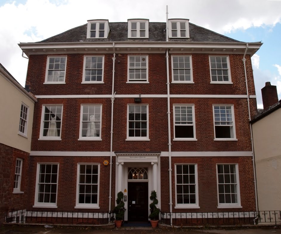 From both a historical and an architectural perspective, the Notaries' House above is an important building. Its history is fascinating and despite some unfortunate modifications its surviving architectural features are of a high quality. The property's story is complex and dates back at least to the first decades of the 15th century.
It stands on the site of what was once part of a group of buildings occupied by members of the cathedral's clergy and which were constructed between c1410 to c1430 around a narrow central courtyard. The west range consisted of a great hall with an exceptional hammer beam roof, known today as the Law Library. There was also an east range, now No. 9a Cathedral Close and a south range, now No. 9 Cathedral Close.
 The north range is believed to have contained high status living rooms such as a solar and large bed chambers, and it was upon the site of this north range that the Notaries' House was built in the late-17th century. (Two of the other three medieval ranges from the early 15th century, the south range and the west range, all survive relatively intact. The east range was much-altered in the late-1600s but still contains significant medieval material.)
The aerial photograph right c1930 shows the extent of Nos. 8, 9 and 9a highlighted in red. In the context of the 15th century it would've been a property of enormous size. The Notaries' House lies in the centre of the plot, its main elevation facing north towards the backs of the townhouses of Bedford Circus. At the end of the long garden is a large outbuilding, also highlighted in red, and described on a 19th century plan as comprising "coachhouses with chamber over, stables and hay loft over, and courtlage". Running between Bedford Circus and the stable block is Egypt Lane, later known as Chapel Street. The building to the far right in the photograph, with a three-storey porch, was the Abbot's Lodge, destroyed by a high-explosive bomb in 1942.
 Nos. 8, 9 and 9a remained as a single residence throughout most of the 16th and 17th centuries. Following the Reformation in the 1530s the cathedral's Dean and Chapter reduced the number of canons residing in the Cathedral Close, preferring instead to lease their large houses to wealthy members of Exeter's gentry. The extensive property was leased to the Bruton family from at least the end of the 1500s until the 1660s. William Bruton is recorded as having paid two shillings for each of his 14 hearths in the 1662/63 Hearth Tax. Clearly the group of buildings constituted a sizeable house.
In 1668 it was leased again to Christopher Bale, a member of the gentry who had married one of the Brutons and who was later to become both the city's mayor and and its MP. Bale divided the accommodation of the sprawling house, keeping at least part of the south range, the hall range and the north range together, and sub-let it as two separate properties. However, it's almost certain that Bale lived in the house at some point himself as the medieval hall contains both his coat of arms, shown above left, and those of his wife, Margaret Bruton, painted onto shields held by the carved angels that terminate the hammer beams.
 The Notaries' House was born from disaster when a major fire broke out in the extensive medieval north range. According to an entry in the Dean and Chapter Act Book from 1692 the "most and the Chiefest part" of the property "was lately burnt down". Fortunately the thick walls of Heavitree stone prevented the fire from spreading to the adjoining ranges.
Bale's lease was extended at a reduced cost as a result of the fire but it was necessary to rebuild the fire-damaged north range. The result of this rebuild was the current Notaries' House, a late-17th century, brick-built mansion in the centre of Exeter and one of the most exceptional buildings of its kind remaining in the city. (A three-storey pavillion, just visible to the left in the photograph top, is now part of the Notaries' House but it was originally the northern end of the medieval east range and so will be discussed in a later post that covers 9a, Cathedral Close.)
Fortunately in 2007 the city council's own Exeter Archaeology Unit (now sadly disbanded as part of city council cost-cutting) carried out an extensive archaeological survey of the building, recording all of the surviving features from different periods. Some of the following information is taken from their detailed report. The Notaries' House was built to a simple plan: five storeys high, including a basement, and only one room deep with two rooms on each floor arranged around a central staircase. It was only intended to act as a wing, an add-on to the surviving medieval ranges at the front. The photograph at the top of this post shows the north-facing elevation of the Notaries' House. This was technically the rear of the property despite it having the visual appearance of the main street facade. The entrance was in fact through the Cathedral Close via an external passageway to the side of the medieval west range.
 The aerial view left shows the south side of the Notaries' House almost completely obscured by the earlier medieval ranges against which it was constructed. The building that is attached to the centre of the south wall, projecting at a right-angle, is the medieval west range that contains the tremendous hammer beam roof.
The facade of the Notaries' House is highly deceptive as its current appearance belies the early date of construction. Frustratingly, all of the two-light mullioned windows were altered during a refurbishment in the early 19th century when the current sash windows were installed. Only the basement floor, now hidden below ground level, retains the original late-17th century windows. But much worse was the refacing of almost the entire facade in modern bricks sometime in the post-war period. The mass-produced bricks and the clumsy modern pointing do the building no favours, although at least the exceptionally attractive proportions of the late-Georgian refurbishment remain. (Some of the original brick work can still be seen at the corners of the north facade as well as on most of the south wall.) Stone banding at first and second floor levels divide the five bays horizonatally and beneath the original flared hip roof, into which is set three dormer windows, is a modillion cornice.
 In front of the building is a brick-built cellar. This is believed to date to c1800, a century after the rest of the house was constructed. The building of the cellar would've raised the exterior ground level significantly and it's likely that a flight of steps originally led up into the house itself. The current portico, supported on pillars with Ionic capitals, was added in the early-19th century. The lovely fanlight of intertwined Gothic arches was installed at the same time.
Despite its current use as office space the house is stuffed with superb details from the late-17th and 18th centuries. Two internal doorways lead off the entrance hall above right into the ground floor rooms. Baroque doorcases with broken pediments and central pedestals from c1740 still remain within the doorways. These doorcases are rare survivals in Exeter, particularly rare for being of such high quality. The entrance hall also has dado panelling and an ornate box cornice, again from c1740.
 The original staircase from c1690 left rises through the full height of the building, from the basement to the top floor, beautifully constructed with a moulded handrail and turned balusters and lit from the windows situated in the central bay of the north wall.
The list of other important surviving features is a long one: a magnificent grey marble fireplace in the dining room from c1740; plaster cornices in both of the downstairs rooms along with the recently rediscovered and significant remnants of bolection-moulded panelling from the late-17th century; large sections of original field panelling in the first-floor rooms as well as extensive cornicing; two more mid-18th century doorcases with broken pediments on the first-floor landing; an early 19th century fireplace, and so on. A blocked doorway on the second floor landing once opened onto a small viewing balcony that looked down into the adjoining medieval hall. (The barley sugar spindles of the balcony are still visible inside the hall). Even the basement has numerous interesting features, such as slate floors and the above-mentioned mullioned windows.
 The photograph right is the view east from a small window on the third floor of the Notaries' House. It looks out over the medieval houses of the Archdeacons of Totnes and Barnstaple, over the still-standing 15th century gatehouse of the Abbot's Lodge (the gatehouse was destroyed in 1942 but superbly reconstructed afterwards) and towards the 18th century terraces of Southernhay West, just visible through the trees.
On the far right are the white walls of the former Chancellor's House, remodelled in the early 18th century and now the Exeter Cathedral School. It is all exceptionally lovely, a collection of buildings of such picturesque charm that they have few rivals in the whole of England.
Incidentally, it is called the Notaries' House because it was for a number of generations used by solicitors as their offices, but the site itself is believed to have been the location for part of the timber barracks of the Second Augustan Legion when the Romans built a fortress here in c55 AD. The above-mentioned stable block was damaged during the Blitz of 1942 and half of the garden disappeared under the post-war service road known as Chapel Street. The other half is a car park. The businesses now based in the house use Chapel Street as their address and the main access in and out of the property is now in Chapel Street, although the house is still technically listed as No. 8, Cathedral Close.
It is perhaps unfortunate that the Notaries' House has been converted into offices and retail space but then it's miraculous that it survived the war undamaged. Many of the modern additions necessary for its current use are a distraction but a huge number of historically interesting features do remain, along with much of the general fabric of the early building. Hopefully the building's Grade II* listed status will protect it for future generations. As the archaeological report concludes, "with its fine staircase, panelling, fireplaces and other fittings, the Notaries' House must rank as one of the best-preserved examples of grand town housing of this period in the city".
Sources
Subscribe to:
Posts (Atom)