Showing posts with label Inns and Taverns. Show all posts

Sunday, 28 April 2013

Little Stile: A Mutineer & A Medieval Gatehouse

On 01 January 1286 Edward I signed a Royal licence allowing the cathedral's Dean and Chapter to construct a security wall around the cathedral precinct punctuated at regular intervals by seven gatehouses. The creation of the precinct wall and gatehouses was a direct response to the murder of the precentor Walter Lechlade in November 1283. During the subsequent trial, overseen at Exeter Castle by the king himself, the city's mayor was implicated in the murder and executed. Little Stile was the name and site of one of these late 13th century gatehouses.

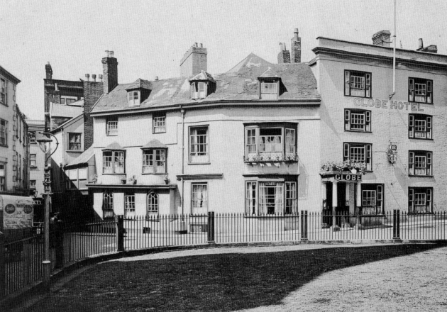
Little Stile was located at the top of South Street. Before 1942 it was really nothing more than a narrow entrance from South Street into Cathedral Yard, similar to St Martin's Lane today. Part of the Globe inn was on the north side and Nos. 1 to 5 Little Stile and the Church of St Mary Major were on the south side.

The image above left shows the narrowness of Little Stile c1900 looking from the Cathedral Yard towards South Street. The side of the Globe inn is visible to the right. Nos. 1 and 2 Little Stile are on the left. A house in South Street can be seen in the distance. Surely it was streetscapes such as this that contributed towards Exeter's former reptuation as being one of the most picturesque cities in Southern England. None of the buildings shown were particularly attractive in their own right. It was more the quaint interplay between the angles of the walls and roof lines, the different textures derived from brick and plaster and the haphazard arrangement of windows and chimneys which gave parts of the city their antique charm. Such scenes can only ever be produced after centuries of gradual evolution and few images convey more vividly the Old World atmosphere of old Exeter.

The image right shows the location of Little Stile overlaid onto a modern aerial photograph. The plots highlighted in red, including the Globe inn, were destroyed during the Exeter Blitz. Nos. 1 & 2 Little Stile and St Mary Major, all highlighted in yellow, survived only to be demolished during the post-war reconstruction. Nos. 3, 4 & 5 Little Stile, known as the 'Three Gables', are still standing and are highlighted in purple. The eastern facade of the Globe inn is clearly visible as it curved round into Little Stile.

One reason that the entrance into Little Stile was so narrow might've been because the gate constructed in 1286 was designed for pedestrians only. The original document from 1286 which detailed the construction of the gates still survives. It describes the Little Stile gate as "one foot gate, five feet wide, opposite the Church of St George where the gate was wide". This suggests that by the end of the 13th century there was already a wider gate at Little Stile, possibly the main entrance gate into the churchyard which the pedestrian gate replaced in 1286. The 1286 document also mentions that the Little Stile gate was of wattle and daub or latticework ("craticula"). It can't have been very substantial and must've required frequent replacement.

The detail from Hedgeland's model of Exeter in 1769 left shows the location of Little Stile highlighted in red. The three buildings on the far right comprised the Globe inn (technically in Cathedral Yard). The houses on the left side of the passageway, Nos. 1 to 6 Little Stile, extended as far as the tower of St Mary Major until it was demolished and rebuilt in the 1860s. The towers and west front of the cathedral are at the bottom of the photo.

The Little Stile gate has some anecdotal connection with the Protestant martyr, Thomas Benet. In 1531 Benet had already secretly nailed notices to the door of the cathedral claiming that the Pope was the Antichrist. According to John Foxe, soon after the notices had been attached to the cathedral Benet "caused his boy...to set the said bills upon the gates of the churchyard. As the boy was setting one of the said bills upon a gate, called the Little Stile, it chanced that one W. S., going to the cathedral church to hear a mass...found the boy at the gate, and asking him whose boy he was, did charge him to be the heretic that had set up the bills upon the gates: wherefore, pulling down the bill, he brought the same, together with the boy, before the mayor of the city; and thereupon Benet, being known and taken, was violently committed to ward." Benet was burnt at the stake in 1531 at Livery Dole just outside the city walls.

The gate crops up now and again in various medieval documents. For example, in 1418 the Dean and Chapter paid 4d for repairing the gate's lock. Unfortunately not much seems to be known about the physical form of the gate itself. All Jenkins had to say in 1806 was that "Little Style-gate" was "not void of ornaments", presumably meaning that it had some kind of decoration or tracery on it. Perhaps it had a coat of arms above the entranceway. A plan of the Cathedral Close by John Hooker dated c1590 shows Little Stile as a single storey gatehouse with an arched doorway in the middle of it, a much less impressive structure than Broad Gate or St Martin's Gate. It was undoubtedly a small gatehouse and was probably renewed several times in the five centuries between the end of the 13th century and the beginning of the 19th century.

The image above shows the view towards Little Stile from Cathedral Yard c1930. No. 1 Little Stile is the building with six sash windows visible to the right of the tree. The Globe inn had been in existence since at least 1675 and most of the structure dated to the 17th century or earlier.

In 1820 there was a serious fire at a baker's house "adjoining to Little Stile". The fire began in the cellar and spread to a number of other properties. According to the 'Exeter Flying Post', the baker's house was "entirely consumed and three or four others in great part destroyed". According to the Lega-Weekes in 1915, No. 1 Little Stile "is said to have been the birthplace of Richard Parker, the famous mutineer of the Nore, who was hanged on HMS Sandwich 30 June 1797. His father, of the same name, was a well-to-do baker". Being within the cathedral precinct the property belonged to the Dean & Chapter.

Richard Parker was born at Exeter in 1767 and baptised at the Church of St Mary Major about 20 seconds walk from No. 1 Little Stile. He was educated at St John's Hospital School on the High Street and rose through the ranks of the Royal Navy to become a lieutenant before being discharged for insubordination in 1794. He returned to the city and married the Scottish Anne McHardy at St Sidwell's Church on 10 June 1795. After a spell in a debtors prison in Edinburgh in 1797 he re-enlisted and was assigned to the HMS Sandwich stationed at the Nore, a sandbank at the mouth of the Thames Estuary. The mutiny broke out in May 1797 following hot on the heels of a mutiny among sailors at Spithead.

Probably as a result of his previous rank in the navy, Parker was made 'President of the Delegates of the Fleet' by the mutineers. The HMS Sandwich had about 1600 men on board when it had only been built to accommodate 750. Such conditions provided a fertile ground for dissatisfaction. The mutineers, led by Parker, listed their grievances in a series of articles handed over to Admiral Buckner on 20 May. The mutineers' main claim was one of better conditions: more time off to visit family and friends; a bigger share of the financial rewards from taking enemy ships; payment prior to the voyage; no officer previously dismissed to be allowed control of a ship without consent of the crew, etc. William Pitt sent a bill through Parliament that would allow the Admiralty to label all mutineers as 'pirates', a charge punishable by death, and the mutiny fell apart when the government refused to give in to the mutineers' demands. On 14 June Richard Parker was arrested and charged with various acts of mutiny. He was hanged from the yardarm of the HMS Sandwich along with 29 others, jumping to his death before he could be executed by the hangman. The fact that Parker had called the 28 mutinous ships "the Floating Republic" only increased the resolve of a British government still reeling from the French and American Revolutions.

The image right shows Parker's 'flagship' the HMS Sandwich at the battle of Cape St Vincent in 1780. Within a short time after Parker's execution popular ballads with Parker and the Nore Mutiny as their theme were circulating around London. In 1845 the tale of Anne Parker's extraordinary attempt to retrieve her husband's body was the topic of a short story by the American poet Walt Whitman called 'Richard Parker's Widow'. Parker was eventually buried at St Mary Matfelon in Whitechapel. The Victorian church was destroyed by bombs in 1940. It's a pity that there's nothing in Exeter to commemorate the birth of Richard Parker whose name, according to Whitman, "shook with terror the foundations of the throne itself".

Anyway, the Little Stile gatehouse was demolished in 1820 probably as a result of the fire which destroyed the baker's house at No. 1. A notice was placed at the site which read: "No passage at night except by leave of the Dean and Chapter". The photo below is another of Hedgeland's model showing the same areas highlighted in red. The only difference is that Nos. 3 to 5 Little Stile are highlighted in purple. It's easy to see from this angle how the buildings on the south side of Little Stile essentially formed one half of a small street running from South Street to the right as far as St Mary Major to the left. The High Street can be seen at the bottom of the photo along with the great Broad Gate, the ceremonial entrance into the cathedral precinct from the late 13th century onwards. The turreted tower of St Petrock's can also be seen, its north wall obscured by properties on the High Street.


The venerable parish church of St Mary Major was demolished in 1864-65. The plan was to reconstruct the church slightly further west to improve the view of the west front of the cathedral. To do this it was necessary to demolish No. 6 Little Stile which became the site of the new church's tower. Built around an open court, No. 6 was an ancient building visible to the left of the 'Three Gables' on Hedgeland's model above.

The photo left shows Nos. 3, 4 & 5 Little Stile (the 'Three Gables') after the reconstruction of St Mary Major and the demolition of No. 6 Little Stile. The church itself was demolished in 1971, but the three houses are now all Grade II listed.

They were described at the beginning of the 19th century as "a tenement built on part of the antient workhouse". In 1540 the site housed craftsmen working at the cathedral although the current buildings were almost certainly constructed between 1650 and 1700.

Many of the oriel windows aren't original e.g. those of No. 4 in the middle are reproductions in a 17th century style, but the three properties form an attractive ensemble. They are typical of many houses built in Exeter over the course of the second half of the 17th century. Several still exist in the High Street but with altered facades e.g. No. 195 High Street.

Nos. 3, 4 & 5 Little Stile narrowly escaped destruction during the Exeter Blitz. The Globe inn, part of which formed the north side of Little Stile, was almost completely destroyed. The buildings on South Street at the narrow entrance into Little Stile were also destroyed. Remarkably, Nos. 1 & 2 Little Stile both survived the Exeter Blitz unscathed.

The photo right was taken in about 1948 after the remains of bomb-damaged buildings, including the Globe inn, had been removed. The cathedral and the Victorian tower of St Mary Major are in the  background. The 'Three Gables' are highlighted in purple. Nos. 1 & 2 Little Stile are highlighted in red.

As we've seen, No. 1 Little Stile, shown closest to the camera in the post-war photo, was rebuilt following a fire in 1820 but was the site of Richard Parker's birthplace in 1767. No. 2 Little Stile was a very narrow property, just one bay wide. Its corner stones and Georgian sash windows are visible to the far left in the photo at the top of this post. For some bizarre reason Nos. 1 & 2 Little Stile were both demolished by the city council in the 1950s as part of the post-war reconstruction. The pre-war aerial photo below shows the dense concentration of housing which surrounded Little Stile prior to 1942.

I can only think that the city's post-war townplanner, Thomas Sharp, was partially responsible for both this and other senseless demolitions undertaken by the city council in the post-war years. When Sharp released his 1946 proposals for the reconstruction and modernisation of the city, 'Exeter Phoenix', he included a detailed, tenement by tenement map of the city centre depicting areas affected by bombs in 1942.

However the map also included a grading for the remaining buildings. Some of these were rated as 'outworn', such as everything in Coombe Street and Frog Street, and others were rated as having 'architectural value', like the surviving terraces in Southernhay or the medieval canon houses in the Cathedral Close. However Sharp adopted a neutral stance towards many other areas i.e. those buildings which weren't outworn nor, in Sharp's opinion, of architectural value. Into this latter category fell the whole of Gandy Street, Goldsmith Street, North Street, Waterbeer Street, Holloway Street, Magdalen Street, the many standing buildings in Sidwell Street, the remaining fragments of South Street, including the 16th century White Hart Hotel and the Jacobean townhouse at No. 67 South Street, both of which Sharp regarded as expendable, as well as the Royal Albert Memorial Museum (which Sharp loathed), a number of buildings on the High Street and the early Victorian terraces in Northerhay.

It seems that either the city council was unable to make its own mind up on what to keep and so relied on Sharp as the arbiter of its taste or the council used Sharp's map as a way of legitimising the removal of perfectly sound structures.

Whichever, the city council seemed to defer to Sharp's judgement as late as the 1970s. I doubt it is just coincidence that the eastern side of North Street, almost the whole of Goldsmith Street, much of Waterbeer Street, Nos. 206 & 207 High Street, Nos. 212 to 219 High Street and the corner of the High Street and Queen Street were all demolished in the 1970s and were all areas highlighted by Sharp as having no architectural value. Nos. 50 to 52 High Street and No. 21 Cathedral Yard were demolished in the early 1960s and they too were rated as being of no value by Sharp. Two others that fell into this category were Nos. 1 & 2 Little Stile and so they were demolished.

Perhaps even worse was the fate of Little Stile itself. Instead of retaining the narrow entranceway into the cathedral precinct, in use since at least 1286, the council decided to follow Sharp's suggestion and obliterate it. A new, much wider entrance was created in 1960 passing over the site of the blitzed Globe inn. Little Stile was built over above right and ceased to exist. The opening in the wall where the passageway once led into South Street just opens into a service area for nearby shops. Following the demolition of St Mary Major in 1971 the Three Gables are now left isolated as the sole survivors of Little Stile below.


The demolition of No. 1 & 2 Little Stile seems inexplicable today. There was no reason why they couldn't have been retained and the narrow route into South Street reinstated. Such areas were part of the city's character, and even with rebuilt structures on its north side Little Stile could still have been an interesting small corner of Exeter, perhaps even with a plaque on the wall of No. 1 to remember the mutineer, Richard Parker.

Drag the slider on the image below to see the Globe inn and Little Stile before 1942 and the same view today. Alternatively, click on 'Show Only Then' or 'Show Only Now'. The site of Little Stile is to the far left in both images. The post-war pedestrian entrance into the cathedral precinct is to the far right in the modern photograph. The less said about the structure which was partially built over the site of the Globe inn the better.
before
after

Sources

Thursday, 21 March 2013

Demolition at Magdalen Street & Holloway Street

The extended demolition of the South Gate area between 1962 and 1977 marked one of the most destructive phases in Exeter's 20th century history. Hardly a single bomb was dropped here during World War II and it largely escaped the catastrophic slum clearances of the pre-war years. The photograph left shows late Regency houses being demolished in Magdalen Street in 1964 © Express & Echo.

At South Gate the destruction of nearly all the historical structures in the area was a result of the inner bypass, a post-war ring road that now carves its way from the top of Sidwell Street, past South Gate, through the West Quarter and on towards Cowick Street and Alphington Street on the opposite side of the river. The scale of the destruction was immense as literally hundreds of pre-war townhouses, shops, courtyards, tenements, gardens and warehouses were bulldozed out of existence and replaced with what is now a multi-lane carriageway.

The clearance at South Gate alone involved the removal of much of Magdalen Street, most of Holloway Street, the whole of Quay Lane, a few surviving buildings at the bottom of South Street, and a large section of Exeter's city wall that had stood since the end of the second century AD. The Edwardian Exe Bridge, Alphington Street and Cowick Street fared little better.

What made the destruction at South Gate particularly unfortunate was its historical importance to the development of the city and the architectural significance of some of its buildings. Following the Exeter Blitz of 1942 it remained one of the Exeter's last intact historical cityscapes and a large number of the buildings dated to the 17th, 18th and early 19th centuries. The photograph above shows the view into Magdalen Street from the bottom of South Street in 1960 © Express & Echo. Nearly all of the houses shown dated from between c1659 and c1720, some with later mid 19th century facades. The photograph below shows the same view today.

As with almost everywhere in Exeter, South Gate has a very long recorded history. Sometimes shortened simply to Southgate, the area was the name given to the junction of South Street, Holloway Street and Magdalen Street where they met outside the great South Gate, itself demolished in 1819. The earliest artifact ever found in the city was recovered at Magdalen Street: a 250,000 year-old flint hand axe. The top of Holloway Street was the site of a Roman legionary cremation cemetery in the 1st centry AD and the Roman road between Topsham and Exeter terminated here. Now a small, picturesque town some four miles from Exeter, Topsham was the Second Augustan Legion's supply base. This route still exists, divided into Topsham Road and Holloway Street. Used by thousands of people every day, it runs in a characteristically straight line between Exeter and Topsham.

Magdalen Street, another road that ended at the South Gate, may also be Roman in origin. The main Roman route from Exeter to Dorchester is known to have run through Heavitree, about a mile outside Exeter. This road probably led originally to the Roman city's East Gate but it's likely that it forked before reaching the city walls with a spur running along Magdalen Road, Magdalen Street and into Exeter at the South Gate. The fork in the road is still present where Heavitree Road splits at what is now Livery Dole.

The image above attempts to show how the Roman roads converged on Exeter in the 3rd century AD. The perimeter of the Roman city walls is highlighted in red. The Exeter-Topsham service road used by the Second Augustan Legion cAD60 is highlighted in orange. The main Roman road from Exeter to Dorchester, ending at the East Gate (2), is highlighted in purple. The spur that forked at what is now Livery Dole (3), which comprised Magdalen Road and Magdalen Street, and which terminated at the South Gate (1) is highlighted in yellow. Except where it was destroyed outside the South Gate in the 1960s and 1970s, and where Paris Street was rerouted following post-war reconstruction, the road plan has remained essentially unchanged.

The image left shows the exterior of the South Gate from Holloway Street in the early 19th century. Magdalen Street runs off to the right. Although the gatehouse was demolished in 1819 the three 17th century timber-framed buildings to the left survived until they were demolished in the 1960s. The narrow entrance into Quay Lane was down the side of the nearest of the three houses.

Another ancient route that led into the area outside the South Gate was Quay Lane, used for hundreds of years to bring goods up into the city from the Quay. Built over the city's in-filled defensive ditch, Quay Lane was lined with small houses that backed onto the city wall, the variety and charm of its townscape the product of centuries of gradual evolution. In c1300 the Greyfriars of Exeter moved their friary from its site at Bartholomew Street inside the city to a large area outside the city walls just south of Holloway Street. Dissolved during the Reformation, some of the friary buildings survived until they were demolished during the English Civil War. The houses on Quay Lane were built within the precinct of the old friary and two roads south of Holloway Street are still known today as Friars Walk and Friars Gate.

The South Gate itself formed one of the main entrances in and out of Exeter. In 1452 Henry VI began a Royal Progress that reached Exeter on 17 July. Accompanied by 300 dignitaries from the city, he was met at Livery Dole by the monks from the city's Greyfriars' priory and Dominican friary. The king and his entourage then processed along Magdalen Road, Magdalen Street and into the city at the monumental South Gate which had been adorned especially for the occasion. Braun and Hogenberg's 1587 map of Exeter above right shows that a small medieval suburb had built up outside the South Gate in Magdalen Street and Holloway Street. Nicholas Smith's mansion of Larkbeare is shown as is Quay Lane and what are probably some of the remaining buildings of the Franciscan friary in the field at the bottom.

In the autumn of 1645, during the English Civil War, the city's Royalist defenders deliberately razed around 80 houses on the south side of Exeter to clear the ground outside the South Gate and to have an improved field of view for cannon and muskets. Most of the houses outside the city walls in the South Gate area, including many in Magdalen Street and Holloway Street, were affected. In his book, 'Two Thousand Years in Exeter', published in 1960 before the 20th century demolition of the area began, Hoskins wrote that "there are a number of gabled houses of late seventeenth-century date in Magdalen Street and Holloway Street. These houses are those that were built again after the war was over to replace those that had been destroyed."

By the end of the 17th century many of the battle-scarred plots had new houses built upon them. One of these was a three-storey, brick-built mansion, constructed in Magdalen Street for Thomas Matthew in 1659. Another significant property was known as Magdalen House, built for Dr Michael Dicker in the first decades of the 18th century. There was also the Valiant Soldier, an inn rebuilt in 1651 which stood on the corner of Holloway Street and Magdalen Street and which was named after those who fought and died during the English Civil War, and the Red Lion inn, its courtyard and timber-framed walls sketched by John Gendell in the 1830s

Benjamin Donn's 1765 map of the city left clearly shows Magdalen Street, Holloway Street and Quay Lane as they converge at the South Gate. It also shows that by the mid 18th century the area had recovered from the damage inflicted during the English Civil War. The evocative drawing below © Exeter City Council by Richard Parker appears on an information panel associated with the site of the South Gate. The drawing shows the junction of South Street, Magdalen Street and Holloway Street c1800. Magdalen House, with a classical pediment at roof level, can be seen on the far right.

Exeter historian Jacqueline Warren left a vivid description of one small part of Magdalen Street prior to its demolition: "Another of these Jacobean houses had a cobbled passage to a court from which a flight of stone steps led to the front doors of two dwellings. This was Bowden's Place, and in its happy, simple design, it had incredible charm. Beyond the first court, and past a fine, early nineteenth century iron gate was another little courtyard where a hefty sandstone buttress held the lower portion of a slate-hung house. The narrow cob-wall passage of one of the houses led to an alley from which could be seen the slightly sagging ridges of original slate roofs. Eventually, through this enchanting maze, one coud reach Holloway Street". Following the pre-war slum clearances, the bomb damage of 1942 and the destructive post-war reconstruction, the post-English Civil War houses around Southgate were some of the oldest domestic buildings still standing in Exeter outside of the Cathedral Close.

The image left shows the 1905 Ordnance Survey map of Exeter overlaid onto an aerial view of the same area today with the following numbering: 1 Site of the South Gate, 2 Quay Lane, 3 Magdalen House, 4 42-46 Magdalen Street, 5 The Valiant Solider Inn, 6 Magdalen Street, 7 Holloway Street, 8 Nos. 71-73 Holloway Street, 9 Site of Franciscan Friary. The route of the city wall is highlighted in purple. The buildings destroyed as a direct consequence of the inner bypass, well over 200 in total, are highlighted in red. Quay Lane was completely demolished, even though the bypass ran nowhere near it, as was most of Magdalen Street. Holloway Street was similarly decimated.

The pre-war aerial view right shows Holloway Street in the foreground running up to the former site of the South Gate (marked with a red arrow) and merging almost without a break into South Street. It shows how densely built-up the area was at the beginning of the 20th century. The majority of the buildings north of the red arrow were destroyed in pre-war slum clearances or during World War Two. The majority of the buildings south of the red arrow were destroyed during the creation of the inner bypass.

The inner bypass was initiated as early as 1949. It was designed to intercept heavy traffic arriving at Exeter from the east and bypass it across the river. In 1950 work began on surveying the proposed route between the top of Sidwell Street and Exe Bridge. Construction didn't commence at Belmont Park near Sidwell Street until 1953 and by 1960 the bypass had reached as far as Magdalen Bridge. 1962 saw the demolition of the Valiant Soldier inn and work started on continuing the bypass from Holloway Street to Exe Bridge.  By 1965 the bypass was complete but work continued on creating a gyratory road system near to the old West of England Eye Infirmary. The last demolitions didn't take place at South Gate until 1977 by which time the road system achieved its present form.

The photograph above shows the view across the junction of Magdalen Street and Holloway Street in the 1940s. The three gabled houses to the right from c1680 are the same ones visible in the early 19th century depiction of the South Gate but with slightly altered facades. The very narrorw entrance into Quay Lane was to the left of the left-hand house.

In his book 'Conservation Today', published in 1989, David Pearce discusses the implementation of so-called Dangerous Structures Notices used by English city councils in the 1960s and 1970s to get rid of inconveniently sited old buildings: "Council-owned, council-neglected then council-condemned was all too frequently the fate of listed structures impeding redevelopment". The idea was that the local authority would purchase a building, willfully neglect it and then issue a DNS on the structure when it was deemed either structurally unsafe or unfit for habitation. As Pearce says, "Exeter swept away splendid seventeenth century merchants' houses as if vying with Bristol to disfigure itself". The photograph below © Express & Echo shows Magdalen Street in the early 1960s when demolition had started in Holloway Street (in the background). The Valiant Soldier inn had already been bulldozed.

Pearce continues: "A building does not need to be neglected for many years before grounds can be discovered for declaring it unsafe, or at the very least unfit for habitation. A classic case occurred in 1977 in Exeter where the city council condemned and destroyed seventeenth and eighteenth century listed houses in Magdalen Street, containing particularly rare plasterwork, which it had originally bought (and then neglected) in connection with what even the local newspaper called 'megolomaniac' traffic schemes". (Another property that suffered the same fate was Whipton Barton, a large 17th century farmhouse in Whipton village. The history of the site dated back to the Domesday survey. Whipton Barton was purchased by the city council in the 1950s, left to fall into disrepair and, despite being a listed building, was demolished in the early 1960s. A block of flats, known as Rennes House, was built on the site.)

The photograph above shows Nos. 42-46 Magdalen Street in 1975. Purchased by the city council they were allowed to rot before being demolished. The late Georgian facade of Nos. 44-46 concealed the mid 17th century brick mansion of John Matthew, a fact that was only discovered when the property was being demolished.

The specific buildings mentioned by David Pearce were Magdalen House and Nos. 42-46 Magdalen Street, all of which were Grade II listed structures. (Magdalen House was listed in 1953. Nos. 42-46 Magdalen Street were listed in 1974. They were all demolished just three years later.) It is shocking to realise that these particular buildings, on the north side of Magdalen Street, did not impede in any way the new road system. The current pavement is on the same alignment as it was before the creation of the inner bypass and where the houses once stood is just a big patch of grass in front of the modern Southgate hotel.

As Jacqueline Warren states, after 1974 Magdalen House "seemed safe, and it has never really been made clear why it was not properly looked after; why it was demolished instead of restored". Other important buildings suffered the same fate. No. 36 Holloway Street, known as Holloway House, was granted Grade II listed status in 1953. It was a large brick townhouse built at the end of the 17th century, its three-storey facade set back from the road. It was demolished in 1980. No. 35 Holloway Street dated to 1797 and was listed in 1973. It too was demolished. Nos. 48-56 Holloway Street were also Grade II listed in 1973. These were mid-19th century houses with stucco facades and an unusual string course and cornice that curved up the face of the houses following the slope on which the houses were built. These too were demolished. The west side of Holloway Street was almost completely obliterated. Nearly 400 metres of pre-war frontages were torn down leaving just three, traffic-blighted examples near the top to indicate what has been lost. (The three survivors on the west side are Nos. 71-73 Holloway Street, all Grade II listed, shown above and as 8 on the Ordnance Survey aerial view.) The east side fared little better with 'only' around 200 metres of pre-war frontages being demolished.

Not only were most of the affected buildings in Holloway Street and Magdalen Street destroyed without any archaeological or architectural record, but a 30 metre stretch of the Roman city wall was hacked down to ground level by council workmen using pickaxes. As a Scheduled Ancient Monument the city wall was allegedly protected by law but the council applied to the Ministry of Works for permission to demolish it and permission was granted (another large section was destroyed at Eastgate during the post-war reconstruction). The houses in Quay Lane, another area that had little to do with the creation of the inner bypass, were also destroyed. The photograph above shows the large section of the city wall that was demolished to accomodate the inner bypass, now spanned by a pedestrian footbridge. The photograph below shows the view towards the Magdalen Street-Holloway Street junction today.

Changes in legislation during the 1980s made it more difficult for local authorities to destroy listed buildings but, for Exeter at least, it was too late as the obliteration of most of the city's historical fabric was complete. The pre-war slum clearances in Paul Street, Frog Street, Smythen Street, Preston Street and Stepcote Hill, the bombing in 1942 of the High Street, South Street, Bedford Circus and Sidwell Street, the post-war removal of most of the standing structures in the bomb-affected areas, the creation of the post-war inner ring road, the installation of the flood defence system in the 1960s, the rebuilding of the Exe Bridges at Cowick Street and Exe Island, and the creation of the sprawling Guildhall Shopping Centre at North Street, Goldsmith Street and Waterbeer Street has resulted in the wholesale destruction of Exeter as a visually historic city.

The loss of life caused by the Exeter Blitz shouldn't be forgotten but it seems strange that so much emphasis is placed on the physical damage wrought upon the city by German bombers in 1942 when the majority of the architectural losses over the course of the 20th century have been entirely self-inflicted.

Even some of those buildings which now survive, feted as important parts of the city's architectural heritage, only escaped through the post-war endeavors of protestors. For example, in the 1960s and 1970s the city council actively campaigned for the total demolition of the Higher Market in Queen Street, the late Regency houses in Bartholomew West, and the 16th and 17th century houses at No. 226 and No. 227 High Street. (The Higher Market was partially demolished anyway and Nos. 226 and 227 only exist today as shallow facades, their ground floors completely gutted.)

In the city's Royal Albert Memorial Museum is a display of medieval, Tudor and Jacobean metal door fittings that were salvaged from the ashes of buildings destroyed in 1942. These fittings are accompanied by an information panel that makes the bizarre assertion that "after so much destruction people were determined to look after the historic buildings that remained".

There are of course instances of the post-war city council salvaging historical buildings e.g. the remaining fragment of old Larkbeare House further down Holloway Street, the much-publicised 'House That Moved' (moved to the edge of the inner bypass) or, more recently, the restoration of Cricklepit Mill, but the extent of the demolition that took place around Exeter following World War Two is quite at odds with the museum's bold claim. It was only exceptional conservation cases that were considered to be of any importance. Although the general background noise of lesser streets and perhaps lesser buildings provided context, coherence and visual proof of organic development over centuries it was, unfortunately, regarded as expendable.

Two other issues deserve mention. One is Exeter's over-burdened road system. The inner bypass was completed in the 1970s when both car ownership and the population of the city were much lower. I'm sure it was lovely to speed around the semi-empty new road system in the early 1970s but anyone who has queued along Alphington Road, Topsham Road, Holloway Street, Western Way, Magdalen Street or Cowick Street will understand that the inner bypass now suffers from major gridlock at key times of the day. The situation will only become worse given the thousands of new houses that are being thrown up around the city's outskirts. It seems all that demolition only provided a temporary solution to what is becoming an increasingly big problem.

The other issue is the poor architecture that was built in the South Gate area following the creation of the road system. These squat blocks of flats have no redeeming features other than their lack of verticality (although at least if you're in it you don't have to look at it.) Like so much of Exeter's post-war architecture, they wouldn't appear out of place on an industrial estate. What was once the great historical approach into the city is today a barren wasteland of roads, junctions, roundabouts and traffic lights.

Sources

Sunday, 18 March 2012

The Bear Inn on South Street & the Abbots of Tavistock

Tavistock lies about 30 miles west of Exeter, town and city separated by the wild granite upland of the Dartmoor National Park. The abbey at Tavistock was founded in 974 by Ordulf, an Anglo-Saxon Ealdorman of Devon, and received its Royal Charter from King Ethelred II in 981.

Ordulf, reputedly a giant of enormous stature, has some connection with Exeter. A story recounted by William of Malmesbury in the 12th century states how Ordulf broke open the doors of the city's East Gate using just his foot.

Swelled by endowments of land and property across Devon and Cornwall, the abbey grew throughout the Middle Ages to become the wealthiest monastic foundation in the south-west of England. Medieval Exeter was the pre-eminent religious, cultural and economic centre of Devon and Cornwall. Priors and abbots from across the region had residences within the city for their own private use. These included the Abbots of Torre, Hartland, Dunkeswell, Buckfast and Newenham. The Abbots of Tavistock Abbey had property in the city at a very early date. The Domesday Book of 1086 records that the abbey possessed a house in Exeter obtained from lending money to a burgess, one of Exeter's citizens, and receiving the house as a sort of bond or pledge in return.

The image above shows the original entries from the Domesday Book relating to the monastery's Exeter property. "Terra Eccle de Tavestock" refers to the ecclesiastical lands owned by the abbey. Included in the list of lands owned by the abbey is the lower extract. It refers directly to Exeter ("In civitate Exonia") and the house ("una domu") of a burgess. The property generated 8d in customs to the king. Was this Saxo-Norman property the seed from which the opulent townhouse on South Street later flowered? It is impossible to say as its location is unknown but it remains an exciting possibility.

It is certain though that the Abbots of Tavistock did have a townhouse in Exeter and it was located on the corner of Bear Street and South Street. It formed part of a remarkable collection of properties from the Late Middle Ages which clustered around the south side of Exeter Cathedral left. 

These included the Deanery, the Bishop's Palace, the Chantry and the Archdeacon of Exeter's House. On the other side of South Street, almost opposite the Abbot of Tavistock's residence, was the townhouse of the Prior of Plympton Priory, later the Black Lions Inn. It's worth remembering that, along with the cathedral itself, there were also over thirty chapels and churches, a Benedictine priory, a Dominican friary and numerous canons' houses, all contained within the 93 acres of the medieval walled city.

It's not known how frequently the abbots stayed at their Exeter townhouse or when it was first used as an inn. By the 16th century at least it was being rented out to citizens of the city.
In 1535 "Le Bere Inn alias Bere" situated in "vico Australi" i.e. South Street, was leased by the last abbot, John Peryn, to Edward Bridgeman and his wife, Jane. This Edward Bridgeman was probably the Warden of Exebridge. Only a citizen of significant wealth could've afforded to take on the tenancy of the abbots' residence. Tavistock Abbey was engulfed by the Dissolution of the Monasteries and in 1539 the abbey was surrendered to the king.

The abbey buildings were demolished and its lands scattered, many of them falling into the hands of John Russell, the 1st Earl of Bedford and owner of Bedford House in Exeter. (The eldest son of the Duke of Bedford still holds the title of Marquess of Tavistock.) In 1546 William Abbot was sold the lease of "the Beare Inn at Exeter, late of the monastery of Tavestock" by Henry VIII for £20. (This was presumably the same William Abbot, Sergeant of the Wine Cellar at Hampton Court, who also received the buildings at Hartland Abbey in North Devon.) Abbot sold the premises just two years later to Griffin Ameridith and John Fortescue. In 1566 the city's former mayor, William Bucknam, endowed Grendon's Almshouses in Preston Street with the Bear Inn, and the site remained in the possession of the trustees of the Grendon charity until the 1880s.

Precise details of the abbots' townhouse remain elusive. The most intriguing source for the property's medieval appearance is Alexander Jenkins' description of 1806: "Great part of the old buildings, particularly the Chapel, was standing a few years since; they were built from freestone, of excellent Gothic workmanship, decorated with fretwork panels, mutilated inscriptions, and different sculptures were seen, and over the cornice even with the battlements was a cabossed statue of a Bear, holding a ragged staff between its paws". Another brief description from 1701 mentions that the coat of arms of Tavistock Abbey and its founder were to be seen in painted glass in the great window of the dining room along with the figure of a man standing on a bridge (a reference to the above-mentioned Edward Bridgeman who must've had that particular detail installed in the 1530s).

The crenellated building mentioned by Jenkins probably functioned as a gatehouse with a central passageway leading from South Street into an inner courtyard, around which might've been grouped the dining hall, chapel, private chambers and service rooms. The exact layout is unknown and it's impossible to say what alterations were made to the property once it entered lay ownership in the 16th century. It must've all been built on a lavish scale commensurate with the wealth of the abbey itself and should perhaps be regarded as one of Exeter's most significant medieval houses. The embattled front of the Bear Inn, undoubtedly an impressive sight in its own right, seems to feature on both the 1587 Braun and Hogenberg map of Exeter (based on a plan by John Hooker) and also on Hooker's own 16th century plan of South Street, both left.

Throughout the 17th and 18th centuries the Bear Inn was a focus for Exeter's lucrative woollen cloth trade. The inn's close proximity to the Serge Market on South Street resulted in it becoming a centre of commerce in its own right. According to Hoskins, "thousands of pounds changed hands" at the inn on market days as dealers met within the extensive premises to trade with each other. The Serge Market had been moved to South Street by the late 1600s. When Daniel Defoe visited Exeter in 1727 he described the market as "well worth a Stranger's seeing" and believed it to be the "greatest in England" after the market in Leeds. He was also told that the market could generate up to £100,000 in transactions every week. The Bear Inn was also one of the places in the city where Charles II was proclaimed as King of England following the Restoration in 1660.

Throughout the 1600s and 1700s, the Bear Inn was an important centre for carrier services (the equivalent today would be something like the Royal Mail's Parcelforce, TNT or Fedex). The carrier service involved the transportation of goods rather than people and used enormous 'flying wagons' stacked high with various merchandise. By c1798, one of these carrier companies, headed by Robert Russell, was operating from the Bear Inn. In 1800, having taken out a lease on the premises, he set about rebuilding it. Jenkins reported in 1806 that "This venerable pile of buildings being in a ruinous state, was pulled down, and a dwelling house, offices, etc. erected on the site, by Mr. Robert Russell".

It's difficult to know the exact nature of Russell's alterations but it's clear that significant portions of the old Bear Inn survived the remodelling.

The image right shows the extent of Russell's premises as they appear on the 1876 Ordnance Survey map overlaid onto a modern aerial view of the same area. The premises have been highlighted to show three quite distinct elements. The building highlighted in purple still survives as No. 25 South Street. This was probably the newly-constructed "dwelling house" mentioned by Jenkins and was a product of the c1800 rebuilding. The house was used by Russell as his own private residence. The property is now known as The Presbytery and is associated with the Church of the Sacred Heart. The large area highlighted in red was also part of the early 19th century alterations, although it's possible that bits of the Bear Inn remained embedded within the later construction. These were the business's offices and warehouses. The entrance from South Street was through large arched openings leading into a spacious courtyard around which were grouped warehouses, a granary, stables, blacksmiths' and wheelers' workshops and a counting house. The openings in the front of the building allowed the wagons to enter the premises directly from the street.

The most interesting part of the premises is highlighted in yellow. According to the 1876 map, this long, narrow plot was the 'Abbot's Town House (Tavistock)'. It was certainly a large fragment of it, probably the north range which extended from South Street all the way along the south side of Bear Street as far as the boundary wall of the Chantry in Deanery Place. This was to become the house and/or offices of Russell's Exeter manager and business partner, Robert Thomas. I believe that the entirety of Russell's premises shown on the 1876 OS map retained at least the approximate footprint of the abbot's 15th century townhouse, possibly including the central courtyard. Comparison with cars and vans shown in the aerial photograph gives some indication of its enormous size.

The sketch of 1881 left, which I've crudely coloured, depicts the South Street facades which made up Russell's wagon offices and warehouse. It is the only known image of these structures in existence. The brick building to the far right, Russell's own house, is the still-surviving No. 25 South Street. Next to it are the four arched openings which led into the courtyard behind. This central part probably replaced the embattled gatehouse structure mentioned by Jenkins and depicted in the 16th century by Hooker and Hogenberg.

To the left, coloured yellow and standing on the corner of South Street and Bear Street, is the property labelled as the 'Abbot's Town House' on the 1876 map. It is quite clearly of an earlier date compared with the other buildings. It's difficult to be sure but the side wall at least, disappearing down Bear Street, was almost certainly made of thick stone walling. The single bay, three-storey facade under a hipped roof was probably timber-framed and post-dated the Reformation. According to Lega-Weekes, a forge stood further up Bear Lane at the rear of the Bear Inn where the horses that pulled Russell's wagons were shod. The photograph below right shows the site of the Abbot of Tavistock's townhouse today. Russell's residence at No. 25 South Street is to the right. The rest of the buildings shown in the 1881 sketch are on the site of the Catholic Church of the Sacred Heart.

The Bear Inn continued in operation in some form as an inn even after Russell's alterations of c1800 which, according to Jenkins, saw the "venerable pile" demolished (although something of it clearly survived).

An announcement in the 'Exeter Flying Post' dated 03 December 1801 stated that John Holman had taken on the Bear Inn which "is lately fitted up neat and convenient". This version of the inn probably occupied just the building on the corner of Bear Street and South Street, the rest having disappeared under Russell's alterations. (Without a detailed plan of the 17th and 18th century buildings it's impossible to say if all of the abbot's townhouse was used as an inn or whether part of it had been divided to provide private accommodation and a self-contained house.)

Another announcement in the 'Exeter Flying Post' on 10 October 1805 stated that the inn was to be let, "with immediate possession given", and that seems to be the last we hear of the Bear Inn. The lease of the smaller, post-1800 version of the Bear Inn was probably purchased by Russell which is when it became the house of manager Robert Thomas. (Another Bear Inn emerged further up South Street in the 19th century. Also known as the College Kitchen, it was located in the medieval kitchen of the College of the Vicars Choral until it was unfortunately demolished in 1871.)

The detail from Hedgeland's model left shows the approximate extent of the Bear Inn, highlighted in red, prior to Russell's alterations. Unfortunately the form and layout of the individual buildings aren't modelled realistically and there is no sign of Jenkins' "battlements" which Hedgeland would surely have seen for himself.

Russell retired in 1816 but the business continued as a consortium until 1852 when the premises were used by the railway carriers, Messrs Haycock and Gillard. An 1878 directory for Devon shows that the three distinct parts of Russell's premises had been divided into three separate properties. The surviving part of the abbot's townhouse was listed as No. 23 South Street, the dwelling of Misses Louisa and Mary Tole, dressmakers. No. 24 South Street, with the open courtyard behind, was the premises of auctioneer Musgrave Bickford, whose surname can just be made out above the arches on the 1881 drawing. No. 25 South Street, formerly the house of Robert Russell himself, was occupied by Mrs Harriet Norris. All of these properties were still being leased from the Grendon charity over 300 years after the site had first come into the trustees' possession. In the early 1880s the site was purchased from the trustees for a new Roman Catholic church and all of the structures, including the remnants of the abbots' townhouse, were demolished. It was the end of a building which had one of the longest and richest histories of any property in Exeter. The foundation stone for the new church was laid in the Spring of 1883 and, following the completion of the church, the site has remained largely unchanged ever since.

The photograph right shows the view towards Bear Street and what would've been the side wall of the Bear Inn, now replaced with the north wall of the Sacred Heart church.

Why was it called the Bear Inn? It's not known whether the inn lent its name to Bear Street or whether the street, and its precinct gate, lent its name to the Bear Inn. There have been several theories though. Jenkins mentioned a sculpted bear holding a ragged staff that once adorned the battlements, an emblem usually associated with the Earls of Warwick. But this could've easily have been a consequence of the name rather than its origin, added to the front of the inn at any point between the 1400s and 1700s. Lega-Weekes suggested that there might've been a connection between Bear Street and an ancient lych way where coffins placed on biers once stood, although she dismissed the theory on etymological grounds. Michael Fodor traced the name to Bere, a peninsula between the estuaries of the rivers Tamar and Tavy close to the border between Devon and Cornwall. The Abbots of Tavistock "administered the silver mines there for Edward I", but the precise origin of the name remains uncertain.

When the foundations for the tower of the Roman Catholic church were being excavated in 1883 a remarkable find was made at a "considerable depth" below the ground. It was described by antiquarians at the time as "an ancient jug" in the form "of a grotesque animal" and was dated to the 12th century. Made of earthenware, it wasn't a jug at all but an ornamental roof tile or finial of a type once found all across the city. This medieval pottery beast is now in the local museum and a photograph of it appears at the top of this post and left. It would've perched on the apex of a gable looking out across South Street.

According to the Royal Albert Memorial Museum, the animal "was made in one of the potteries which used the sands of streams running off Dartmoor, perhaps that at Bridgetown near Totnes." The museum describes the animal as a "creature" but I wonder if it's not supposed to be a bear. Robert Dymond claimed in 1880 that the Bear Inn had been rebuilt in 1481. Is it possible that the bear-like finial sat on the pre-1481 Bear Inn only to find its way into the ground when the property was reconstructed at the end of the 15th century? It would account for the "considerable depth" at which the tile had been found as well as its location close to the street. Could the pottery animal be the origin of the Bear Inn's name? The Chevalier Inn on Fore Street received its name from a similar ridge tile in the form of a knight on horseback. Either way, this pottery animal and a single window alleged to have come from the Bear Inn and inserted into the Roman Catholic church are the only surviving pieces of the Exeter townhouse of the Abbots of Tavistock.

Sources
Sunday, 12 February 2012

The Black Lions Inn: No. 78, South Street

The old Black Lions inn which stood for centuries in South Street is another of Exeter's frustratingly elusive historical buildings. Since at least the beginning of the 19th century the inn was believed to be the former townhouse of the medieval Priors of Plympton Priory. Numerous priors, abbots and archdeacons in the south west of England had residences in Exeter. It had been the region's pre-eminent religious centre since the foundation of the cathedral in 1050.

The Abbots of Buckfast Abbey owned a large property in the Cathedral Close known as the Abbot's Lodge and the Abbots of Tavistock Abbey owned a house on the opposite side of South Street, later the Bear inn and now the site of the Roman Catholic Church of the Sacred Heart. Nearly opposite the church stood the Black Lions inn. But was it really the Exeter residence of the Priors of Plympton Priory? The Augustinian Priory at Plympton, approximately 33 miles west of Exeter, had been refounded in 1121 by Exeter's bishop, William Warelwast, on the site of a pre-existing Saxon minster or college. Warelwast, the bishop who built Exeter's Romanesque cathedral, was an exceptionally generous benefactor to the Priory at Plympton.

By the time the Priory was dissolved during the Reformation in 1539 it had acquired numerous parcels of land in Exeter, including ground near the Bishop's Palace in Palace Gate, a large house on the corner of Fore Street with Mary Arches Street, another house almost opposite the Guildhall and a house and garden in the parish of St Mary Major. These properties were sometimes rented out and the money channelled back into the Priory which grew to become one of the wealthiest monasteries in Devon. In the light of a 19th century discovery at the Black Lions inn, it is perhaps significant that most of these tenements in Exeter were gifted to the Priory in the 12th century. An impression from the Priory's seal is shown below right.

The house and garden in the parish of St Mary Major is perhaps the most likely candidate for a link between the Plympton Priors and the Black Lions inn. The tenement was situated in "Le Cokerewe" i.e. Cook Row, an ancient name for the upper portion of South Street. Also located on South Street, not far from the site of the Black Lions inn and on the same side of the street, was St George's church which until 1222 had been a daughter church belonging to the Plympton foundation.

Unlikely as it may seem today, South Street was one of the four most important roads in medieval Exeter, the location of the city's most impressive gatehouse and the ceremonial thoroughfare into the city from the south east. It was once lined with a number of prestigious houses belonging to some of Exeter's wealthiest citizens. A document records that a tenement on Cook Row which belonged to Plympton Priory was leased in 1524 to John Alyn for a period of 58 years, rather optimistically considering that the Priory itself was to survive for just another 16. The new occupier was possibly John Allen, who became the city's steward in 1536. Unfortunately there is no firm documentary evidence which proves that the Black Lions inn was either the property leased to John Alyn or that it had any connection with the Priors of Plympton Priory.

The name of the inn is something of a mystery. Robert Dymond suggested that "it is just possible that the Black Lions may have been for a time the town residence of the Carew family, whose shield of arms bears three lions passant, sable". The Carews were one of Devon's most prominent families throughout the late Middle Ages and Tudor period. George Carew was in command of the Mary Rose when it sank in the Solent in 1545 and the 16th century Carew monuments in Exeter Cathedral are studded in heraldry depicting the three black lions passant.

The photograph left shows one of the Carew monuments in Exeter Cathedral. The two-tiered tomb dates to 1589. The lower figure is Sir Peter Carew, depicted in an anachronistic medieval pose and carrying a shield emblazoned with the three black lions of his family's coat of arms. It's not unreasonable to believe that Dymond's theory is accurate but unfortunately there is no direct documentary evidence to support it either. Another source for the name were perhaps two carved lion heads which adorned part of the building. The two lions were drawn by W. G. Croump in his booklet 'Mural Monuments' of 1933 and are shown below right. The Black Lions was in existence as an important tavern and carriers' house by 1637 and in 1721 it was taken over by John Legg. The inn appears as the 'Black Lyon' on Benjamin Donn's 1765 map of Exeter.

One of the first people to write about a connection between the Black Lions inn and medieval monasticism was Alexander Jenkins in his 1806 history of Exeter. Describing the inn, he wrote: it "is a very ancient building, and from its appearance, seems to have been erected for monastic purposes, it occupies a large spot of ground; in the front, which was a few years since rebuilt, is an antique carving representing an angel holding a shield, on which is inscribed the date of 1421, in ancient characters". In his history Jenkins confused the Abbots of Tavistock with the Priors of Plympton but at least he left behind an eyewitness account of the Black Lions inn itself and presumably he was merely recounting a widely-believed tradition regarding its history. It was a tradition which was repeated again and again throughout the 19th century.

What exactly was it about the inn's "appearance" which made Jenkins connect it with "monastic purposes"? What was the exterior like before it was reconstructed? What was the significance of the "antique carving" and the date 1421? The fact that the inn's facade had been rebuilt c1800 probably explains why there are no sketches or illustrations of the facade, despite the inn's evident antiquity.

An advert below left appeared in the 'Exeter Flying Post' in 1850 in which Richard Fletcher announced that he had taken over the running of "that well-known and commodious house, the Black Lions Inn". Fletcher was re-opening the inn on 15 April 1850 after numerous "vast improvements". As well as a new undercover skittle alley the inn could offer "good sitting and smoking rooms, several excellent bedrooms, and some stabling attached". The premises were described in 1873 as being "very large and roomy". In the centre of the premises was a cellar. The inn formerly had a large yard at the back which was used for carriers' vehicles and which was accessed via an entrance from Sun Street.

Another article in the same newspaper from 1855 repeated the claim that the inn was the "ancient town residence of the opulent Priors of Plympton before the dissolution of religious houses by Henry VIII". Fortunately the report also records some intriguing architectural details which help throw some light on the building's medieval origins. There were at least two Perpendicular Gothic windows on the first floor. One was blocked up. The other was described as being "a fine specimen" and "of four lights, foliated as usual or cusped in the head, divided horizontally by a transom". These windows were on the north side of the Black Lions and overlooked No. 79, the premises of Harvey's gunsmiths. A blocked medieval arched entrance also existed on the ground floor. The article's author believed that the stone tablet on the front, dating to 1421, commemorated the year when a portion of the structure was built.

Traces of the site's long history had already been unearthed earlier in the 19th century when a portion of a tessellated Roman pavement was discovered at the rear of the inn and in July 1834 a "curious brass religious tablet" was found "underneath the foundation". According to a contemporary report, the "tablet" was very small, approximately 5cms square, and could've been worn as a locket (although Dymond speculated that it might've been a seal for documents). On one side was a representation of Christ sat in some clouds with the Virgin Mary beneath accompanied by two saints.

The Black Lions inn was largely destroyed in a major fire in September 1873. The story appeared in Trewman's 'Exeter Flying Post'. William Carter and Frederick Baker were walking down South Street at around 2am on a Sunday morning when they saw smoke issuing from the roof of the Black Lions. They watched it for several minutes thinking it was a chimney fire before heading down a passageway at the side of the inn where Carter lifted Baker up so he could peer through a fanlight. Seeing light reflected from a window they found a policeman and told him that they believed there "was a fire at the Black Lions". Some time "elapsed before the flames were visible - first through the fan-light, then gradually from one window and another until the whole front was enveloped in one mass of flame" and when the fire engines arrived "the fire had a strong hold on the premises and was burning furiously" with "dense volumes of black smoke issuing from every window".

At about 3am "the front of the inn fell into the street in a burning mass and exhibited the interior, which glowed like a furnace". The air rushed inside fanning the flames "into still larger proportions" until the "roof and almost the entire building speedily sank bodily to the foundation, casting myriads of sparks towards the heavens and a lurid glare over the city." There were five people in the Black Lions at the time of the fire: Richard Fletcher, the publican; Maria Hepper, Fletcher's elderly mother-in-law; Mrs Sanders, the housekeeper; John Clarke, who worked for Fletcher, and Clarke's nine-year-old sister, Emily. Only Richard Fletcher and John Clarke survived. The inquest recorded a verdict of accidental death on the others.

The surrounding buildings were also affected by the fire. Part of the gunsmith's shop at No. 79 South Street, immediately adjacent to the Black Lions, exploded and destroyed a portion of the north wall but the fire also revealed the extent of the surviving medieval masonry. At least the two side walls were left standing including "a great part" of the north wall with its fine Gothic window intact. The south wall had also survived where "traces of deeply-mullioned Gothic windows" could also be seen. The walls were about 3ft (1m) thick and were built of the "red sandstone of the neighbourhood", presumably red Heavitree breccia. The tablet bearing the date 1421 and mentioned by Jenkins was lost in the fire, despite hopes that it could be retrieved. "Several ardent antiquaries" visited the scene following the blaze and they had "expressed a hope that means would be taken to preserve the fine old window on the north side". The detail from Hedgeland's early 19th century model of the city above right isn't particularly helpful and probably can't be regarded as an accurate depiction of the Black Lions inn. The portion of the model which corresponds with the extent of the inn as it appears on the 1876 Ordnance Survey map is highlighted in red.

One remarkable find was recovered from the ruins of the Black Lions inn in 1873 as the site was being cleared: the capital of a free standing column made from either white limestone or sandstone. Beautifully carved into each of its four sides is the face of man wearing a cap or helmet and with a huge pointed moustache. It is clearly Romanesque work of the late 12th century and is contemporary with the acquisition of various properties in Exeter by the Priors of Plympton Priory. It was an intriguing discovery but striped of its architectural or archaeological context it has lost much of its diagnostic value.

Was it part of the original fabric of the building? Where in the building had it come from? Could it really have remained in situ since the 12th century? Or was it brought in much later as a piece of decoration from another medieval site in the city, such as St Nicholas's Priory or even the Romanesque cathedral itself, as probably happened at the so-called Norman House in Preston Street? Either way, its presence at the Black Lions inn combined with the tradition of the Priors at Plympton Priory can't easily be dismissed. The capital was on display at the Royal Albert Memorial Museum but since the museum's refurbishment it appears to have disappeared into the stock room. A photograph of the Romanesque capital is shown at the top of this post. A detail is shown left.

The fire in 1873 would appear to have been the end of the Black Lions inn but the story has an extraordinary coda. The site of the inn was rebuilt as it was for sale again in 1892 and was still in use as an inn in 1919. During the air-raid of 04 May 1942 the building was again destroyed by fire. The following morning, stood amongst the ruins for the second time in 70 years, were the same medieval walls and Gothic windows which had first been revealed in 1873. The Victorian antiquarians had clearly succeeded in preserving the medieval remains and they must've been incorporated into the new premises when the Black Lions was rebuilt following the 1873 fire.

Fortunately a local architectural historian, Arthur Everett, recorded what he saw soon after the air-raid. According to Everett, the air-raid had revealed "the greater part of the Black Lions inn in South Street". The site measured approximately 23ft wide by 63ft long. Built of red Heavitree breccia, the walls were three stories tall although only the west wall and the north wall now survived (Everett doesn't mention the south wall). Four windows remained in the north wall at ground floor level with a further three windows on the first floor including one which was "of two lights and rather ornate". Everett believed that the first floor was the "principal apartment" of what was once clearly a very extensive medieval property. Everett also reported that there was a "large Georgian house" with the date 1754 on a rainwater head that stood at the back of properties on Sun Street to the north. According to Everett, this house was built over a basement which was medieval in origin and which had a 15th century doorway in it. (Paragon House, an earlier brick-built property on South Street which stood just to the south of the Black Lions inn until 1942 had also retained medieval elements.) The mid-18th century house was destroyed during the air-raid of 1942 along with its cellar so there is no way of investigating further, but Everett suggested the intriguing possibility that this property and the Black Lions inn formed the north and south ranges of a quadrangular residence.

The image right shows part of the 1905 map of Exeter overlaid onto a modern aerial view of the same area. The Black Lions inn is highlighted in red. The South Street Baptist Chapel and the Roman Catholic Church of the Sacred Heart are on the opposite side of the street.

The evidence for the Black Lions inn being at least part of the Exeter residence of the Priors of Plympton Priory is compelling. The medieval building was a substantial structure and there are several precedents in Exeter for large ecclesiastical houses being constructed around a quadrangle. A single range from one such building, the courtyard house of the medieval Archdeacons of Exeter, still remains in nearby Palace Gate and there are several others in the Cathedral Close but it was a layout which was never anything but rare in the city and nearly always associated with ecclesiastical dwellings. The South Street building had high status Gothic windows which are at least suggestive of an ecclesiastical origin. If the Priors of Plympton did have a townhouse directly on South Street then it was almost certainly on the site of the Black Lions inn.

It's also possible to theorise about the history of the building's construction. The Romanesque capital found in 1873 could conceivably have been part of a 12th century version of the property but the Perpendicular windows are a big clue that the complex was substantially rebuilt in the 15th century. It seems that the vast majority of the walls were constructed from red Heavitree breccia, a stone which wasn't quarried in any great quantity in Exeter until the middle of the 14th century. Perhaps the date of 1421 recorded the completion of the modifications. A number of similar buildings in Exeter were also reconstructed at around the same time along with many of the city's parish churches. If it was indeed built around a quadrangle then there was probably a gatehouse range to the east which gave access into the courtyard via South Street with perhaps a service range to the north. To the west a further range possibly consisted of a hall for dining and entertaining. Everett's "principal apartment" was in the south range and might've contained the private chambers used by the Priors of Plympton when they resided in Exeter.

The image left shows the Black Lions inn highlighted in red. What might've been the north range described by Everett was possibly on the site of a group of buildings called Victoria Place, although the exact location of his Georgian house of 1754 is uncertain. The projected north range is highlighted in purple. Also highlighted are what might've been the sites of the east and west ranges, the four ranges creating a four-sided courtyard house.

Was evidence of the quadrangular arrangement of the buildings still apparent when Jenkins described it in 1806 and is that what he meant when he referred to the inn's "appearance" revealing its "monastic purposes"? The fact that there were Gothic windows on the sides of the Black Lions inn meant that they must've looked out onto an open area when first installed in the 15th century. A courtyard at the side of the inn is noted in the 1873 report of the fire and traces of it are still visible on the 1905 map. No mention of a western hall is made by 19th century antiquarians so presumably, if it had ever existed, it was demolished by c1850 at the latest. The same probably applies to the eastern gatehouse range although it's possible that traces of it remained in the buildings fronting onto South Street as late as 1942. Perhaps the northern service range was replaced with the Georgian house of 1754 as seen by Everett although it apparently retained its medieval cellars. The southern range alone survived, altered over the centuries and evolving into the Black Lions inn whose walls remained standing in South Street following the air-raid of 1942. This is all supposition. It sounds plausible but much depends on the medieval building being quadrangular in its plan and with all of the buildings now destroyed there's no way of testing the theory.

Having survived the fire of 1873 and the bombing of 1942 the extensive medieval walls and Perpendicular windows of the Black Lions inn were, in the words of Arthur Everett, "wantonly destroyed, after the raid" by Exeter City Council as part of the post-war reconstruction of South Street. Today there is no sign above ground that the inn or the medieval townhouse ever existed and only the Romanesque capital survives as a fragment of one of Exeter's most historically interesting buildings. The shop on the corner of South Street and the post-war entrance into Market Street below now stands on the site of the Black Lions inn.

Sources
Related Posts Plugin for WordPress, Blogger...