Showing posts with label Post-War Demolition. Show all posts

Sunday, 28 April 2013

Little Stile: A Mutineer & A Medieval Gatehouse

On 01 January 1286 Edward I signed a Royal licence allowing the cathedral's Dean and Chapter to construct a security wall around the cathedral precinct punctuated at regular intervals by seven gatehouses. The creation of the precinct wall and gatehouses was a direct response to the murder of the precentor Walter Lechlade in November 1283. During the subsequent trial, overseen at Exeter Castle by the king himself, the city's mayor was implicated in the murder and executed. Little Stile was the name and site of one of these late 13th century gatehouses.

Little Stile was located at the top of South Street. Before 1942 it was really nothing more than a narrow entrance from South Street into Cathedral Yard, similar to St Martin's Lane today. Part of the Globe inn was on the north side and Nos. 1 to 5 Little Stile and the Church of St Mary Major were on the south side.

The image above left shows the narrowness of Little Stile c1900 looking from the Cathedral Yard towards South Street. The side of the Globe inn is visible to the right. Nos. 1 and 2 Little Stile are on the left. A house in South Street can be seen in the distance. Surely it was streetscapes such as this that contributed towards Exeter's former reptuation as being one of the most picturesque cities in Southern England. None of the buildings shown were particularly attractive in their own right. It was more the quaint interplay between the angles of the walls and roof lines, the different textures derived from brick and plaster and the haphazard arrangement of windows and chimneys which gave parts of the city their antique charm. Such scenes can only ever be produced after centuries of gradual evolution and few images convey more vividly the Old World atmosphere of old Exeter.

The image right shows the location of Little Stile overlaid onto a modern aerial photograph. The plots highlighted in red, including the Globe inn, were destroyed during the Exeter Blitz. Nos. 1 & 2 Little Stile and St Mary Major, all highlighted in yellow, survived only to be demolished during the post-war reconstruction. Nos. 3, 4 & 5 Little Stile, known as the 'Three Gables', are still standing and are highlighted in purple. The eastern facade of the Globe inn is clearly visible as it curved round into Little Stile.

One reason that the entrance into Little Stile was so narrow might've been because the gate constructed in 1286 was designed for pedestrians only. The original document from 1286 which detailed the construction of the gates still survives. It describes the Little Stile gate as "one foot gate, five feet wide, opposite the Church of St George where the gate was wide". This suggests that by the end of the 13th century there was already a wider gate at Little Stile, possibly the main entrance gate into the churchyard which the pedestrian gate replaced in 1286. The 1286 document also mentions that the Little Stile gate was of wattle and daub or latticework ("craticula"). It can't have been very substantial and must've required frequent replacement.

The detail from Hedgeland's model of Exeter in 1769 left shows the location of Little Stile highlighted in red. The three buildings on the far right comprised the Globe inn (technically in Cathedral Yard). The houses on the left side of the passageway, Nos. 1 to 6 Little Stile, extended as far as the tower of St Mary Major until it was demolished and rebuilt in the 1860s. The towers and west front of the cathedral are at the bottom of the photo.

The Little Stile gate has some anecdotal connection with the Protestant martyr, Thomas Benet. In 1531 Benet had already secretly nailed notices to the door of the cathedral claiming that the Pope was the Antichrist. According to John Foxe, soon after the notices had been attached to the cathedral Benet "caused his boy...to set the said bills upon the gates of the churchyard. As the boy was setting one of the said bills upon a gate, called the Little Stile, it chanced that one W. S., going to the cathedral church to hear a mass...found the boy at the gate, and asking him whose boy he was, did charge him to be the heretic that had set up the bills upon the gates: wherefore, pulling down the bill, he brought the same, together with the boy, before the mayor of the city; and thereupon Benet, being known and taken, was violently committed to ward." Benet was burnt at the stake in 1531 at Livery Dole just outside the city walls.

The gate crops up now and again in various medieval documents. For example, in 1418 the Dean and Chapter paid 4d for repairing the gate's lock. Unfortunately not much seems to be known about the physical form of the gate itself. All Jenkins had to say in 1806 was that "Little Style-gate" was "not void of ornaments", presumably meaning that it had some kind of decoration or tracery on it. Perhaps it had a coat of arms above the entranceway. A plan of the Cathedral Close by John Hooker dated c1590 shows Little Stile as a single storey gatehouse with an arched doorway in the middle of it, a much less impressive structure than Broad Gate or St Martin's Gate. It was undoubtedly a small gatehouse and was probably renewed several times in the five centuries between the end of the 13th century and the beginning of the 19th century.

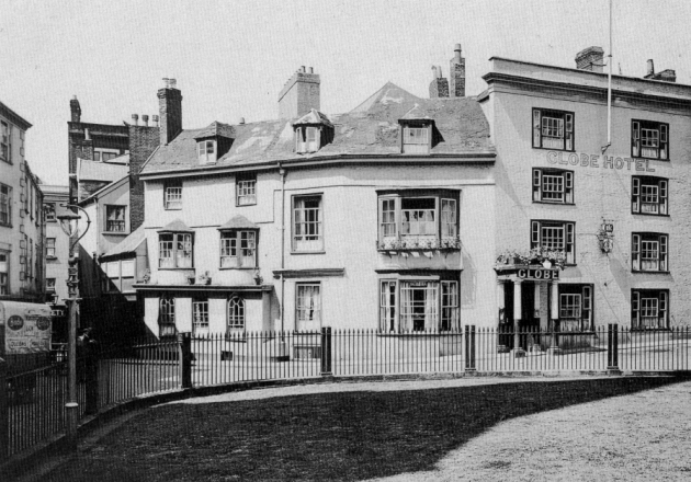
The image above shows the view towards Little Stile from Cathedral Yard c1930. No. 1 Little Stile is the building with six sash windows visible to the right of the tree. The Globe inn had been in existence since at least 1675 and most of the structure dated to the 17th century or earlier.

In 1820 there was a serious fire at a baker's house "adjoining to Little Stile". The fire began in the cellar and spread to a number of other properties. According to the 'Exeter Flying Post', the baker's house was "entirely consumed and three or four others in great part destroyed". According to the Lega-Weekes in 1915, No. 1 Little Stile "is said to have been the birthplace of Richard Parker, the famous mutineer of the Nore, who was hanged on HMS Sandwich 30 June 1797. His father, of the same name, was a well-to-do baker". Being within the cathedral precinct the property belonged to the Dean & Chapter.

Richard Parker was born at Exeter in 1767 and baptised at the Church of St Mary Major about 20 seconds walk from No. 1 Little Stile. He was educated at St John's Hospital School on the High Street and rose through the ranks of the Royal Navy to become a lieutenant before being discharged for insubordination in 1794. He returned to the city and married the Scottish Anne McHardy at St Sidwell's Church on 10 June 1795. After a spell in a debtors prison in Edinburgh in 1797 he re-enlisted and was assigned to the HMS Sandwich stationed at the Nore, a sandbank at the mouth of the Thames Estuary. The mutiny broke out in May 1797 following hot on the heels of a mutiny among sailors at Spithead.

Probably as a result of his previous rank in the navy, Parker was made 'President of the Delegates of the Fleet' by the mutineers. The HMS Sandwich had about 1600 men on board when it had only been built to accommodate 750. Such conditions provided a fertile ground for dissatisfaction. The mutineers, led by Parker, listed their grievances in a series of articles handed over to Admiral Buckner on 20 May. The mutineers' main claim was one of better conditions: more time off to visit family and friends; a bigger share of the financial rewards from taking enemy ships; payment prior to the voyage; no officer previously dismissed to be allowed control of a ship without consent of the crew, etc. William Pitt sent a bill through Parliament that would allow the Admiralty to label all mutineers as 'pirates', a charge punishable by death, and the mutiny fell apart when the government refused to give in to the mutineers' demands. On 14 June Richard Parker was arrested and charged with various acts of mutiny. He was hanged from the yardarm of the HMS Sandwich along with 29 others, jumping to his death before he could be executed by the hangman. The fact that Parker had called the 28 mutinous ships "the Floating Republic" only increased the resolve of a British government still reeling from the French and American Revolutions.

The image right shows Parker's 'flagship' the HMS Sandwich at the battle of Cape St Vincent in 1780. Within a short time after Parker's execution popular ballads with Parker and the Nore Mutiny as their theme were circulating around London. In 1845 the tale of Anne Parker's extraordinary attempt to retrieve her husband's body was the topic of a short story by the American poet Walt Whitman called 'Richard Parker's Widow'. Parker was eventually buried at St Mary Matfelon in Whitechapel. The Victorian church was destroyed by bombs in 1940. It's a pity that there's nothing in Exeter to commemorate the birth of Richard Parker whose name, according to Whitman, "shook with terror the foundations of the throne itself".

Anyway, the Little Stile gatehouse was demolished in 1820 probably as a result of the fire which destroyed the baker's house at No. 1. A notice was placed at the site which read: "No passage at night except by leave of the Dean and Chapter". The photo below is another of Hedgeland's model showing the same areas highlighted in red. The only difference is that Nos. 3 to 5 Little Stile are highlighted in purple. It's easy to see from this angle how the buildings on the south side of Little Stile essentially formed one half of a small street running from South Street to the right as far as St Mary Major to the left. The High Street can be seen at the bottom of the photo along with the great Broad Gate, the ceremonial entrance into the cathedral precinct from the late 13th century onwards. The turreted tower of St Petrock's can also be seen, its north wall obscured by properties on the High Street.


The venerable parish church of St Mary Major was demolished in 1864-65. The plan was to reconstruct the church slightly further west to improve the view of the west front of the cathedral. To do this it was necessary to demolish No. 6 Little Stile which became the site of the new church's tower. Built around an open court, No. 6 was an ancient building visible to the left of the 'Three Gables' on Hedgeland's model above.

The photo left shows Nos. 3, 4 & 5 Little Stile (the 'Three Gables') after the reconstruction of St Mary Major and the demolition of No. 6 Little Stile. The church itself was demolished in 1971, but the three houses are now all Grade II listed.

They were described at the beginning of the 19th century as "a tenement built on part of the antient workhouse". In 1540 the site housed craftsmen working at the cathedral although the current buildings were almost certainly constructed between 1650 and 1700.

Many of the oriel windows aren't original e.g. those of No. 4 in the middle are reproductions in a 17th century style, but the three properties form an attractive ensemble. They are typical of many houses built in Exeter over the course of the second half of the 17th century. Several still exist in the High Street but with altered facades e.g. No. 195 High Street.

Nos. 3, 4 & 5 Little Stile narrowly escaped destruction during the Exeter Blitz. The Globe inn, part of which formed the north side of Little Stile, was almost completely destroyed. The buildings on South Street at the narrow entrance into Little Stile were also destroyed. Remarkably, Nos. 1 & 2 Little Stile both survived the Exeter Blitz unscathed.

The photo right was taken in about 1948 after the remains of bomb-damaged buildings, including the Globe inn, had been removed. The cathedral and the Victorian tower of St Mary Major are in the  background. The 'Three Gables' are highlighted in purple. Nos. 1 & 2 Little Stile are highlighted in red.

As we've seen, No. 1 Little Stile, shown closest to the camera in the post-war photo, was rebuilt following a fire in 1820 but was the site of Richard Parker's birthplace in 1767. No. 2 Little Stile was a very narrow property, just one bay wide. Its corner stones and Georgian sash windows are visible to the far left in the photo at the top of this post. For some bizarre reason Nos. 1 & 2 Little Stile were both demolished by the city council in the 1950s as part of the post-war reconstruction. The pre-war aerial photo below shows the dense concentration of housing which surrounded Little Stile prior to 1942.

I can only think that the city's post-war townplanner, Thomas Sharp, was partially responsible for both this and other senseless demolitions undertaken by the city council in the post-war years. When Sharp released his 1946 proposals for the reconstruction and modernisation of the city, 'Exeter Phoenix', he included a detailed, tenement by tenement map of the city centre depicting areas affected by bombs in 1942.

However the map also included a grading for the remaining buildings. Some of these were rated as 'outworn', such as everything in Coombe Street and Frog Street, and others were rated as having 'architectural value', like the surviving terraces in Southernhay or the medieval canon houses in the Cathedral Close. However Sharp adopted a neutral stance towards many other areas i.e. those buildings which weren't outworn nor, in Sharp's opinion, of architectural value. Into this latter category fell the whole of Gandy Street, Goldsmith Street, North Street, Waterbeer Street, Holloway Street, Magdalen Street, the many standing buildings in Sidwell Street, the remaining fragments of South Street, including the 16th century White Hart Hotel and the Jacobean townhouse at No. 67 South Street, both of which Sharp regarded as expendable, as well as the Royal Albert Memorial Museum (which Sharp loathed), a number of buildings on the High Street and the early Victorian terraces in Northerhay.

It seems that either the city council was unable to make its own mind up on what to keep and so relied on Sharp as the arbiter of its taste or the council used Sharp's map as a way of legitimising the removal of perfectly sound structures.

Whichever, the city council seemed to defer to Sharp's judgement as late as the 1970s. I doubt it is just coincidence that the eastern side of North Street, almost the whole of Goldsmith Street, much of Waterbeer Street, Nos. 206 & 207 High Street, Nos. 212 to 219 High Street and the corner of the High Street and Queen Street were all demolished in the 1970s and were all areas highlighted by Sharp as having no architectural value. Nos. 50 to 52 High Street and No. 21 Cathedral Yard were demolished in the early 1960s and they too were rated as being of no value by Sharp. Two others that fell into this category were Nos. 1 & 2 Little Stile and so they were demolished.

Perhaps even worse was the fate of Little Stile itself. Instead of retaining the narrow entranceway into the cathedral precinct, in use since at least 1286, the council decided to follow Sharp's suggestion and obliterate it. A new, much wider entrance was created in 1960 passing over the site of the blitzed Globe inn. Little Stile was built over above right and ceased to exist. The opening in the wall where the passageway once led into South Street just opens into a service area for nearby shops. Following the demolition of St Mary Major in 1971 the Three Gables are now left isolated as the sole survivors of Little Stile below.


The demolition of No. 1 & 2 Little Stile seems inexplicable today. There was no reason why they couldn't have been retained and the narrow route into South Street reinstated. Such areas were part of the city's character, and even with rebuilt structures on its north side Little Stile could still have been an interesting small corner of Exeter, perhaps even with a plaque on the wall of No. 1 to remember the mutineer, Richard Parker.

Drag the slider on the image below to see the Globe inn and Little Stile before 1942 and the same view today. Alternatively, click on 'Show Only Then' or 'Show Only Now'. The site of Little Stile is to the far left in both images. The post-war pedestrian entrance into the cathedral precinct is to the far right in the modern photograph. The less said about the structure which was partially built over the site of the Globe inn the better.
before
after

Sources

Friday, 26 April 2013

The Destruction of the High Street After 1942


The destruction of 50% of the High Street during the Exeter Blitz was obviously a disaster for the city's historical landscape, but around 220 metres of unbroken pre-war frontages did survive on both sides of the street for about half of its length. The remaining buildings ran from the corner of South Street almost as far as St Stephen's Church and included some of the High Street's oldest domestic houses (most of which still fortunately survive). The postcard above is of the view up the High Street c1968. Most the buildings shown, apart from The Guildhall, were demolished in the 1970s.

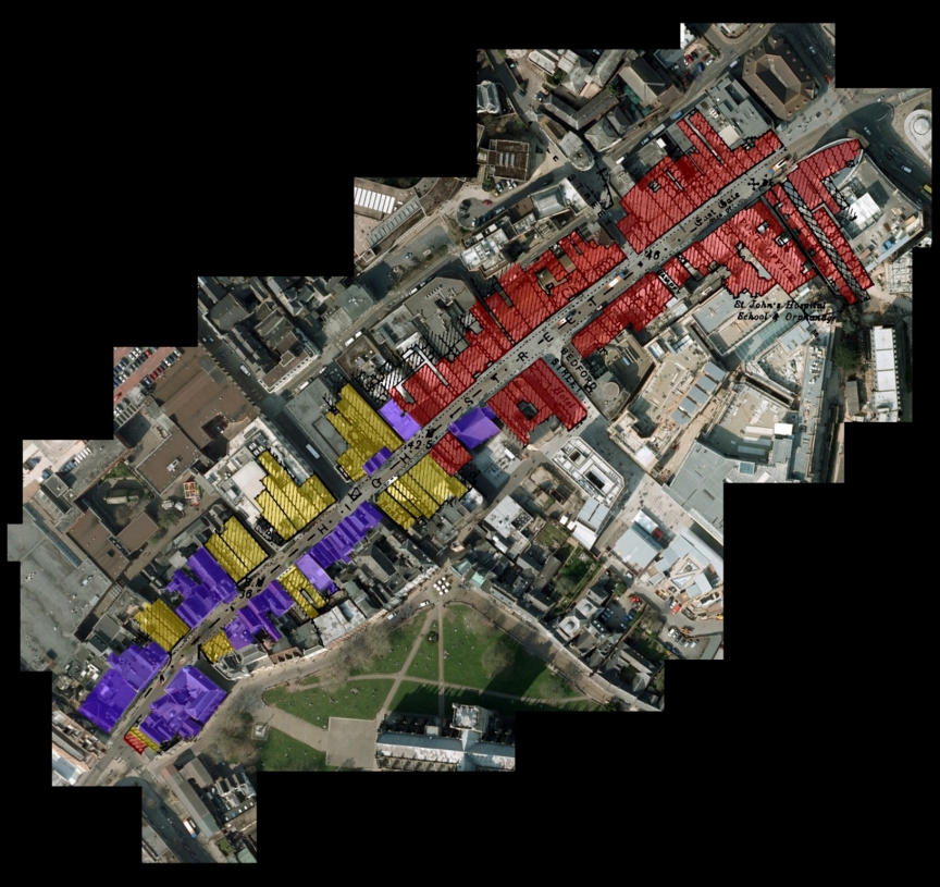
The image right is based on a 1905 map of the city combined with a modern aerial view of the same area. It shows the 50% of the High Street which remained largely unaffected by bombing in 1942. The plots highlighted in red, mostly to the right, were destroyed in 1942 along with a single building on the south-west corner.

The properties highlighted in purple are pre-war buildings which still exist today. The most easterly of these are St Stephen's Church and No. 229 High Street.

The plots highlighted in yellow show the location of buildings on the High Street which survived the Exeter Blitz but which were destroyed between 1950 and 1980, most of them by Exeter City Council for redevelopment. The map illustrates the sobering fact nearly half of the High Street that existed after 1942 was subsequently demolished in the post-war years. A solitary building at the High Street's most western point was destroyed in 1942. This was No. 74 High Street which stood on the corner of the High Street and South Street. No. 73, which survived the Blitz, was demolished in the 1950s as part of the scheme to widen South Street. A fine timber-framed facade from c1600, one of the few still left within the city walls, which stood at the rear of No. 72 High Street was inexplicably demolished at the same time.

The 1950s also saw the demolition of the remains of No. 36 High Street, as well as Nos. 37 & 38 High Street. No. 36 High Street dated to c1805 and featured in Richardson and Gill's 1924 book 'Regional Architecture in the West of England'. It was a narrow four-storey building, notable for the bow windows on its top three floors. The top two storeys were damaged in 1942 and it was reduced in height to just the ground floor and first floor. Instead of being reconstructed the remaining two floors were cleared away as part of the redevelopment of Colsons department store which had occupied the building prior to 1942 (now Dingles).

Next to No. 36 was No. 37 High Street, shown left c1955. This was a timber-framed merchant's house, possibly built as a pair, dating from c1600 and very similar in appearance to the still-surviving Nos. 41 & 42 High Street. Harbottle Reed poked around inside the building in 1931 and reported that there was little of interest to be found, but it's highly likely that original features were concealed behind later alterations and that much of the original fabric remained. The property, one of only three twin-gabled timber-framed houses still surviving in the city centre with their street facades intact, was allegedly found to be structurally unsound. It was subsequently demolished in the 1950s. (The two surviving examples are the above-mentioned Nos. 41 & 42 High Street and No. 67 South Street.)

No. 38 stood on the corner of the High Street and St Martin's Lane. It was formerly a branch of the West of England and South Wales District Bank. Built of stone in the mid 19th century, the exterior of No. 38 was ornately decorated with pilasters capped with Corinthian capitals and egg-and-dart moulding around the doorway. The building is shown in the photo right c1925. No. 38 High Street was also bizarrely demolished in the 1950s and replaced with yet another drab, red brick block.

The buildings opposite Nos. 36, 37 & 38 High Street fared little better. The carved, mid 17th century wooden facade of No. 227 High Street is now one of the city's landmark buildings. Despite being granted Grade II* status in 1953, from 1958 onwards Exeter City Council repeatedly tried to secure its demolition for road-widening. Another application for its destruction was made in 1960 and yet another in 1962. Objections made at the time ensured the building's survival but in 1971 almost the entire structure was destroyed for new retail space. Only the timber-framed facade was left standing and the ground floor was gutted to become a pedestrianised walkway. The demolition took place without any archaeological record being made although a number of original features, including a mullioned window, a flagstone passageway and part of a substantial 17th century staircase, are known to have been destroyed.

(The photo left shows part of the High Street which was left undamaged after the Exeter Blitz. The facade of No. 228, the 'Civet Cat' emporium, is just visible to the far right. Although the photo itself was taken c1910, all of the buildings shown remained essentially unaltered until they were largely demolished between 1971 and 1980. Only the gutted timber-framed facades of No. 227 and No. 226 still survive.)

The same fate awaited the adjacent No. 226 High Street. Dating to the mid 16th century, the timber-framed facade of No. 226 had already been heavily restored in 1907. It too had been granted Grade II* listed status in 1953 but the city council tried to demolish it for road-widening in 1958. This is when the now infamous cartoon appeared in the local paper accompanied by the caption "Come to Exeter and Watch the Natives Pull it Down". Like the planned demolition of No. 227, the proposed destruction of No. 226 High Street caused an uproar. By 1962 the council had been granted permission from the government to demolish the building but the plans were hampered by objections led by Professor William Hoskins and the Exeter Civic Society. In 1971 the entire building was demolished apart from the timber-framed facade. The ground floor was also gutted to make a pedestrian walkway. Only the facades of Nos. 226 & 227 High Street now remain but it's quite obvious that even they only now survive because of the actions of the Exeter Civic Society.

Referring to the treatment of Nos. 226 & 227 High Street, Peter Thomas has written that their "facades only exist as considerable vandalism took place with the whole insides of the buildings being ripped out. It can be said that the frontages are only held as a token of the past and are a classic example of the lack of interest and damage that has been done to the City's buildings in the past".

It's worth comparing this with the bold claim made in the council-run Royal Albert Memorial Museum that after the destruction of World War Two "people were determined to look after the historic buildings that had survived". Unfortunately the evidence belies the veracity of such a claim. In terms of the attitude of the local authority to the city's historical architecture it was as if the Exeter Blitz had never happened at all.

Although the facades of Nos. 226 & 227 High Street were largely retained the pre-war buildings on either side of them were demolished. No. 228 High Street stood on the western corner of the High Street and Gandy Street. It
had been sold to the city in 1759 and became known as the Mansion House or the Mayoralty House. It seems to have been largely rebuilt in 1791.

During the 19th century the premises had a show room converted out of the former banqueting hall of the mayors of Exeter. In 1843 it became the premises of the Civet Cat, a company selling luxury perfumes, soaps and other high-end objects and after World War Two was the location of Timothy Whites hardware store. No. 228 High Street had a plain Georgian facade which, unfortunately, seems to have resulted in it being one of the least photographed buildings on the High Street. It was demolished in the late 1980s and replaced with the yet another bland red-brick block (now the Britannia Building Society). I've no idea if anything of interest was found when the building was demolished.

On the west side of Nos. 225/226 & 227 was No. 224 High Street. This was a narrow building, which must've been constructed on the site of a medieval tenement. It was four storeys tall, the top two floors each having a single bay window which projected out over the pavement below. It was demolished in 1971 without any systematic record made into the building's architectural history. As the structure was being pulled down an A-framed truss belonging to the roof of a two-storey house was founded embedded in the side wall of No. 225/226. The truss dated to the 14th or 15th century. Its place in the evolution of either No. 224 or No. 225/226 will never be known. The only record of the discovery are a series of photos taken by a passer-by.

The neo-Classical building next to No. 224, which curved around the corner from the High Street into Queen Street, was part of a terrace of nine early Victorian townhouses, most of which were located in Queen Street itself. The entire terrace was demolished by the city council in 1971 and replaced with a structure that was infinitely worse than anything constructed in the upper High Street during the post-war rebuilding. No. 224 and the corner building of the Queen Street terrace are both shown in the photo above left. The photo above right shows what replaced the pre-war buildings in 1971. Even the artfully placed tree can't disguise the structure's hideousness.

The post-war demolition of the eastern corner of the High Street and Queen Street junction was bad enough. Unfortunately the western corner was similarly destroyed. The buildings shown in the photo left extended down the north side of the High Street from Queen Street, past the entrance into Goldsmith Street and almost as far as The Guildhall. Despite surviving the Exeter Blitz they were all demolished between 1975 and 1980 and replaced with the current Marks & Spencer building (a structure variously described as "wretched", "an inept lump" and "a dog's dinner").

Most of the demolished buildings i.e. Nos. 212 to 219 High Street dated from c1890 to c1910 and had in turn replaced a number of tall properties from c1700. It's been suggested to me that traces of these earlier buildings remained embedded in the fabric of their late Victorian replacements but the entire row was destroyed in the 1970s without record. Although not the finest structures in Exeter, the buildings added much to the varied architectural character of the already battered High Street. The fact that this was at the time part of the city's central conservation area makes their demolition even more deplorable.

Nos. 206 & 207 High Street right stood on the western corner of the High Street and Goldsmith Street. Both buildings were granted Grade II listed status in 1974. The facade of No. 206 probably concealed elements of an earlier structure but externally at least the properties dated to c1830. Both buildings were completely demolished in 1979, the original facades replaced with modified concrete casts. At the back of No. 207 was the late 18th century No. 1 Goldsmith Street. It was also Grade II listed but, like nearly all of Goldsmith Street, it was demolished for redevelopment in the 1970s.

Slightly further down on the other side of the street stood Nos. 50 to 52 High Street. This comprised two separate buildings from the 18th century or earlier. They backed onto No. 21 Cathedral Yard. A narrow, flagged passageway called Exchange Lane ran underneath the facade of No. 51 linking the High Street to the cathedral precinct. Nos. 50 to 52 were demolished in 1963 and replaced with the remarkably poor 'Burger King' building. No. 21 Cathedral Yard, an early 18th century townhouse with a Grade II* listed interior, was shamefully demolished with the consent of the city council in 1964.

On the corner of the High Street and Broadgate were three Grade II listed buildings, Nos. 61, 62 & 63 High Street. All three dated to around the end of the 17th century, although they had received a single Victorian brick facade in the 19th century. The buildings were all badly damaged by fire in the mid 1970s and subsequently demolished. An entirely new structure was built on the site.

Almost opposite the entrance into Broadgate stood Nos. 196, 197 & 198 High Street, shown left highlighted in red c1965. At the core of No. 196 High Street was a late 16th century townhouse which had been heavily remodelled in 1914. The remodelling had involved the removal of some oriel windows overlooking the High Street and the destruction of a plasterwork ceiling. Despite these alterations it appears that significant parts of the 16th century building remained in situ and the property was given Grade II listed status in 1953.

Nos. 197 & 198 dated to the 18th century or earlier. They stood on a single large medieval tenement plot which had probably been subdivided in the 15th century. The rears of both properties extended as far back as Waterbeer Street which they fronted as Nos. 21 & 22 Waterbeer Street. The parts of the buildings sited on Waterbeer Street both dated to c1700 and had Grade II listed status. It seems highly likely that the parts which fronted onto the High Street were of a similar age but had received modernised facades in the 18th century. Nos. 196, 197 & 198 High Street were all demolished in 1973 to create a pedestrianised entrance into the new Guildhall shopping centre. Nos. 21 & 22 Waterbeer Street were demolished at the same time. A late Elizabethan fireplace and wooden window from No. 196 High Street were left in situ following the demolition and can now be seen in the show room of H Samuel in the shopping centre


The image above shows part of the High Street that survived the Exeter Blitz intact. The buildings highlighted in red was Nos. 61, 62 & 63 High Street destroyed by fire in the 1970s. The properties highlighted in yellow were all deliberately demolished between 1950 and 1980. It's fortunate that anything survived on the north side of the High Street at all. According to Jacqueline Warren, in 1960 the city council's planning department came up with a scheme which would've seen the complete demolition of every standing pre-war building on the north side of the High Street except for The Guildhall and the Turk's Head. This would've resulted in the destruction of Nos. 192, 193 & 194 High Street, No. 195 High Street and Nos. 199 & 200 High Street, all of which are now Grade II listed. As Jacqueline Warren wrote: "As we look at the city today, and consider what has been done to it, [we] can only console ourselves with the thought, 'it could have been even worse!'" Indeed it could've been worse, but not by much.

The postcard view below c1985 shows the gutted timber-framed facades of Nos. 226 & 227 High Street surrounded by a sea of insipid post-war redevelopment. The building to the far right, No. 229 High Street, only dates to 1930 and was partially damaged by fire in 1942. (It was built on the site of the birthplace of Sir Thomas Bodley, the founder of the Bodleian Library at Oxford). One of its magnificent Jacobean windows were salvaged from No. 20 North Street at the end of the 19th century (the other is presumably a copy). All the pre-war buildings to the left of No. 229 survived the Blitz undamaged only to be largely demolished during post-war redevelopment.


It can easily be argued that the local authority turned the disaster of 1942 into a catastrophe as far as Exeter's historical architecture was concerned, perpetuating a trend that was already well established long before bombs started falling on the city. To the post-war destruction of the High Street can be added the vast post-war demolitions that took place around Goldsmith Street, Waterbeer Street and North Street, in Magdalen Street and Holloway Street, Cowick Street and Alphington Street not to mention the pre-war demolition of the West Quarter, Paul Street, Frog Street and Edmund Street.

Perhaps it's easy with the benefit of hindsight, but it doesn't take much imagination to envisage Exeter as it might've been had the local authority retained most of the city's surviving pre-war architecture following the Blitz of 1942, repaired and/or reconstructed the Georgian splendour of Southernhay, Dix's Field and Bedford Circus, retained the medieval street plan and integrated the many surviving buildings in bomb-damaged areas with new structures instead of demolishing them completely. All of this would've been perfectly feasible and well within the capabilities of the city at the time. Instead of which destruction was piled upon demolition and demolition was piled upon destruction. It is a genuinely tragic tale..

The image below shows a complete aerial view of the High Street. Sites destroyed or badly damaged during the Exeter Blitz are highlighted in red. Buildings demolished between 1950 and 1980 are highlighted in yellow. Surviving pre-war structures are highlighted in purple, and even five or six of these were only built between 1900 and 1942. Only a few pathetic remnants now survive of what was once Exeter's most historically important street.


Sources

Saturday, 30 March 2013

St Edmund's Church, Exe Bridge

St Edmund's Church is, or was, another of the city's ancient parish churches. It is shown above in a very rare photograph from the 1860s, the dark stone church contrasting with late 17th century timber-framed houses that cluster around it. St Edmund's, or St Edmund on the Bridge, actually stood on the medieval Exe Bridge, as did the timber-framed houses, their sagging galleries and upper floors supported by a network of wooden timbers springing out from the stone arches of the bridge itself.

Like Holy Trinity and St Mary Major, the medieval fabric of St Edmund's suffered from almost complete reconstruction during the 19th century. Apart from portions of the tower, the church in the photograph only dated to the 1833 but the origins of the church were much older. There is some uncertainty about the date of the first church. According to David Francis, the first church on the site "was probably a very small chapel taken down when the first stone Exe Bridge was built c.1200". Cresswell believed the chapel was late Saxon in origin. Unfortunately there's no archaeological evidence to support such an early structure. A 'chaplain of the bridge' is mentioned in 1196, soon after construction of the bridge had started, and it's possible that this chaplain was associated with St Edmund's.

A chapel on the bridge dedicated to St Edmund was definitely in existence by c1200 as it is mentioned in the will of Peter de Palerna. If there was an earlier structure on the site then it would've been demolished and rebuilt when the new bridge was built. The chapel of St Edmund didn't become a parish church until 1222.

The image right shows a modern aerial view of the church overlaid onto which is the 1905 street plan of the city: remains of St Edmund's (1), the remains of the medieval Exe Bridge (2), the site of the lower leat (3), the site of the higher leat (4), the site of the West Gate (5), the original location of The House That Moved (6), the so-called 'Tudor House' in Tudor Street (7). The houses, factories and warehouses highlighted in red were demolished when the inner bypass was created in the 1960s and 1970s.

The great stone bridge that spanned the Exe, approximately 750ft long, was begun c1190 and probably took 40 or 50 years to complete. By the end of the 13th century there were three religious sites on it. A chantry chapel dedicated to St Mary, which stood opposite St Edmund's, and a chapel dedicated to St Thomas at the far (western) end of the bridge. St Edmund's stood at the eastern end, outside the city walls and close to the West Gate. It was built parallel with the bridge across two of the bridge's arches. The fabric of the church was supported underneath by stone pillars to allow water to pass underneath the church and through the spans of the bridge. (The place where the bridge started at its eastern end was more marsh than fast flowing river, at least for most of the year, the Exe being much wider and shallower then than it is today).

The drawing left shows St Edmund's Church in the 1830s before it was reconstructed. It looks like a normal street but it is in fact the carriageway of the medieval Exe Bridge with houses built on either side over the arches of the bridge. The two gabled houses next to the church tower are the street frontages of the two gabled houses that can be seen next to the church in the photograph at the top of this post.

The 13th century church was possibly a simple single-celled structure constructed from the same purple volcanic trap as the bridge itself. It underwent a series of alterations in the following centuries. The bell tower was added between 1448-1449 when Bishop Lacy was offering indulgences to anyone who would contribute towards the cost of a new belfry and a side aisle was added c1500. Fortunately a brief description of the late medieval church was made just after it had been almost completely demolished. The description appeared in an article in 'The Gentleman Magazine' in 1835: "The exterior, as far as could be seen, was built of red sandstone so common in the buildings of Exeter. The mullions and arches of the windows and doors, were executed in freestone, forming a pleasing variety. The doorcases and the two windows in the Church, with the lower one in the tower, are of the latter part of the fifteenth century. The square windows and door towards the east, are not earlier than the reign of Elizabeth. This portion of the structure may have been the residence of a chantry priest at a prior period. The interior consisted of a nave and side-aisle, divided by arches, either circular or very obscurely pointed, the columns octagonal, with moulded caps". The "red sandstone" was probably Heavitree breccia, a relatively poor quality stone used in Exeter from the 1350s onwards.


 The drawing above was executed by the author of the article. It was, he said, "taken from an opposite window on 1st August 1830, at which time the demolition of the Church was talked about. A crack was visible in the north wall; but probably the fondness for improvement which has led to the rebuilding of several of the churches in the city, was the actual cause of its demolition. The protecting Genius of the Church would exclaim 'repair,' but 'not destroy;' but this small still voice would be drowned in the yells of the Demon of Improvement". It was ever thus.

Alexander Jenkins fills in a couple more details relating to the post-1833 church in his brief description of 1806: "The tower is small and not very lofty. It is crowned with a small spire and vane; it has six bells, which from their situation near the river have a very pleasing sound". Jenkins also mentions some remnants of painted glass in the windows that featured the heraldic shields of various Devon families.

The photo right shows two of the remaining medieval pillars which once supported the floor of St Edmund's Church allowing water to flow under the church and through the bridge arch on the right.

The church was not only one of the four retained in Exeter during the Commonwealth that followed the English Civil War but it might've been the location for the city's first printing press. A printing press is known to have existed at Tavistock Abbey prior to the Reformation. After the abbey was dissolved in 1539 the press disappears. But in a will of 1567 the rector of St Edmund's, John Williams, cites "all such stuff as tooles concerning my printing with the matrice with the rest of the tooles concerning my press". It's probable that the rector was related in some way to William Williams, a known monk at Tavistock Abbey and that the press mentioned in 1567 was once at Tavistock Abbey.

On the morning of 19 August 1800 there was a tremendous thunderstorm over the city that raged for five or six hours. The church was struck by lightning, much to the excitement of the population. The "dial of the clock was beaten to pieces, the machinery of the chimes was deranged, the wire attached to it melted or burnt to small pieces, and scare any part of the church escaped injury". The sulphurous atmosphere left in the church after the strike made it difficult for the sexton to remain long in the building. The lightning conductor attached to the weathervane was blamed for carrying the lightning into the church itself.

By 1830 the church's future was in doubt. A report in the 'Exeter Flying Post' on 25 February announced that divine service had been suspended because of the "insecure state of St Edmund's Church".

A meeting of the parishioners had been called by the rector "to consider the best means for reinstating it by a new edifice". On Thursday 06 September 1832 the 'Post' claimed that "the demolition of the Church of St Edmund on the Bridge in this city...was commenced on Monday morning". The same paper announced on 25 July 1833 that "We notice with much satisfaction the progress towards a finish of the New Church of St Edmund's on the Bridge - to that part of our city it will be a great ornament". If only.

Beatrix Cresswell in her 1908 book on Exeter's parish churches stated that "the present building had the misfortune to be erected in 1833, therefore, as a building, there is nothing more to be said for it". Perhaps that's a little unkind. I think the almost contemporary rebuilding of Holy Trinity resulted in a much poorer structure. At least the rebuilt St Edmund's above left had the look of Exeter's other remaining medieval parish churches, even if it had been stripped of nearly all of its historical fabric.


The postcard view above shows St Edmund's Church as it appeared at the beginning of the 20th century looking towards the city (the tower of St Mary Steps can just be seen amongst the rooftops in the background). The cityscape here remained little changed until the 1960s. With the creation of the new Exe Bridge in the 1770s part of the medieval bridge continued to be used as Edmund Street. The bridge was widened in 1854. The work involved in widening it can be seen in the stonework at the bottom of the photograph. This was all removed when the bridge was excavated in the 1960s, returning the structure back to its medieval form.

The aerial photograph below from c1930 shows part of the West Quarter and the leats of Exe Island. The Custom House is bottom right. St Edmund's Church is highlighted in red. Almost none of the buildings shown now survive. Many were swept away as part of slum clearances in the 1930s but the majority were demolished in the 1960s and 1970s during the creation of the inner bypass. The area today is completely unrecognisable. Similar devastation occurred outside the South Gate.

The new church was designed by the local architects of Cornish & Julian (Robert Cornish was also responsible for the Holy Trinity rebuild). A lot of the medieval material was recycled into the rebuilt structure. According to Cresswell, the tower was "in some measure retained, the top repaired with an ornamental parapet".  The galleries that extended down the sides of the old church were replaced with a single gallery at the west end. The old painted glass mentioned by Jenkins was gathered into the windows of the north wall.

According to Cresswell the old font had been left in a stone mason's yard and the one in the church was modern i.e. from the 1830s. The pulpit was fashioned from the 15th century remains of its predecessor. Cresswell also claimed that some "old and rather uncomfortable looking open benches" had been brought from the cathedral at the time of the restoration i.e. in the 1870s.

There were eight bells in the tower which, said Cresswell, "had a very pleasant tone". The old church had three bells in 1533 and five when it was demolished in 1832. The oldest bell that Cresswell saw was dated 1721 with four others dated 1731. Three others dated to 1833 and were installed when the church was rebuilt.

In 1881 the issue of how much of the medieval tower had been left standing resulted in some bickering between the rector of St Edmund's and the city council. In that year the late 17th century houses shown adjacent to the church tower in the photograph at the top of this post were demolished by the city council as part of a slum clearance. The rector wanted to know why the council wasn't prepared to pay for the repairs necessary to the wall of the tower where the house nearest to the tower once stood. He cited a precedent. In 1879 the city council had demolished No. 210 High Street, an early 17th century house that was next to Allhallows Church in Goldsmith Street, and had paid for repairs on the church's newly-exposed wall.

But the council were having none of it and informed the rector that "whereas in the case of Allhallows the house was built against the church, in St Edmund's the church was built against the house". The rector responded with a letter from the churchwardens which stated that "it was obvious that the original wall of the old church was not disturbed when the present church was built (some fifty years since) from the fact that the walls of the old houses still adhered to the west end, the reason doubtless being that to remove the wall would endanger the safety of the premises". The churchwardens also complained that two large beams that had supported the timber-framed houses had been left in the west wall of the church. The churchwardens were undoubtedly correct but it appears that the parishioners ended up paying for the repair work themselves.

The photograph above left shows the surviving west wall of the tower that was at the centre of the disagreement in 1881. Constructed largely from red Heavitree breccia with some random blocks of purple volcanic trap, it is almost certainly a surviving fragment from the medieval church of St Edmund. The remaining part of the tower's south wall, shown above right with the entrance doorway, dates to the rebuilding of 1833. The photo below shows the Edwardian Exe Bridge c1910 looking towards New Bridge Street and the city centre. New Bridge Street was created at the end of the 18th century and bypassed the route into Exeter from the west along the medieval Exe Bridge. The isolated tower of St Edmund's Church is visible to the right.

The church probably started to go downhill after the Georgian Exe Bridge was opened in the 1770s, although Jenkins claimed in 1806 that "the whole of the decorations and furniture in this small edifice is kept in perfect repair". It was effectively sidelined as New Bridge Street made for a much easier entry into the city from the west, and St Edmund's was always one of Exeter's smaller medieval parishes even before the new bridge was built. The church was last used for regular services in 1956 and was then partially damaged by fire in 1969. Although the damage wasn't irreparable, the construction of the inner bypass and the consequent demolition of almost every surrounding building resulted in St Edmund's own demolition in 1973 after nearly 800 years of use as a site of worship. What was believed to be the surviving portions of the medieval building were retained and left as a 'picturesque' ruin along with the remains of the old Exe Bridge now "incongruously sited on a roundabout" (Pevsner & Cherry).


Sources

Saturday, 23 March 2013

Magdalen House: Nos. 39 & 40 Magdalen Street

Magdalen House at Nos. 39 & 40 Magdalen Street was another pointless casualty of the post-war inner bypass at South Gate. The property was built at the beginning of the 18th century for Dr Micheal Lee Dicker. Dicker was born at Exeter in 1683. In 1717 left Exeter to spend a year working with the eminent physician Herman Boerhaave at Leiden in The Netherlands. Upon his return to Exeter he set up a practice and, in 1741, was one of the founding physicians of the Royal Devon and Exeter Hospital. According to George Oliver writing in 1821, "the doctor was a Quaker, and the smart house in Magdalen Street which he built for himself was his residence". Norman Penny commented in 1929 that Dicker had "resided in a large and handsome house erected by himself and still standing in Magdalen Street".The house is highlighted in red in the 1960 photograph of Magdalen Street above © Express & Echo.

Michael Dicker married in 1727 and it's likely that the house was constructed at the same time. It was a fairly early example of a large brick-built residence in Exeter, although surviving photographs show that it had a coat of white stucco covering the brick.

The house was built on three storeys, its facade divided into five bays and capped with a classical pediment. Beneath the pediment a richly decorated entablature ran across the entire face of the building. According to Jacqueline Warren in 'Aspects of Exeter', "the facade of Magdalen House was remarkable. The dentil band and ovolo decoration of its pediment, the shells, acanthus leaves and urns of its frieze made it unique in Exeter". The five bays of the house were divided 1-3-1 by four fluted pilasters capped with Corinthian capitals, one at each corner and one under each corner of the pediment.

Michael Dicker died in 1752, bequeathing a fine three-quarter length portrait of himself by Devon-born artist Thomas Hudson to the hospital. The portrait, above right © Royal Devon & Exeter Hospital, still hangs in the board room of the old hospital in Southernhay. The interior of the house was partially remodelled in the early 19th century when a large extension was added at the back. Soon after 1868 the house was sold and unfortunately divided into two separate properties, Nos. 39 & 40 Magdalen Street. The ground floor rooms were converted into shops and the property stayed like this until its destruction. At the time of its demolition in 1977 the house still contained a number of important historical features e.g. a fine Regency staircase lit from above by a glass cupola and panelling in the hallway from when the house was first built.

Magdalen House was of sufficient importance that it was among the first wave of buildings in Exeter to be listed, receiving Grade II listed status on 29 January 1953 (many others weren't listed until 1974 or later). Although threatened by the inner bypass the property didn't actually impede the creation of the road system at all. The bypass was essentially finished before the building was destroyed.

The aerial view left shows the location of the property highlighted in red. As can be seen, the modern pavement follows almost the exact same line as the one depicted on the 1905 Ordnance Survey map of Exeter. There was absolutely no reason why most of the entire row of historically interesting properties on the north side of Magdalen Street between South Street and the entrance into Southernhay couldn't have been retained. (The 1659 mansion of John Matthew at Nos. 44-46 was scandalously destroyed at the same time.) Trinity Street, which ran behind Magdalen House next to the city wall, was also cleared of all its remaining properties. According to Jacqueline Warrren, after 1974 Magdalen House "seemed safe, and it has never really been made clear why it was not properly looked after; why it was demolished instead of restored".

Whatever the reason, it is sadly typical of the sort of mindset that has predominated across England since the beginning of the 20th century. Change is, of course, inevitable, but before the 20th century change in Exeter had been a piecemeal process, with single buildings usually replacing other single buildings.

When large-scale developments did take place, as in Southernhay at the end of the 18th century, they usually took place on undeveloped land leaving the centre of the city relatively free from mass development (one notable exception was the creation of the Higher Market and Lower Market in the 1830s). It was this gradual evolution over a period of nearly 1000 years that characterised the city's landscape at the end of the 19th century. As far as its impact on Exeter's historical impact is concerned the Exeter Blitz of 1942 was clearly a disaster, but it is a huge mistake to view the Blitz in isolation without taking into account the pre-war slum clearances, the destructive nature of the post-war reconstruction, and the massive post-war redevelopment that took place for the Guildhall Shopping Centre, the flood prevention scheme and the inner bypass in the 1960s and 1970s, all of which were under the direct control of the local authority. It is little surprise that only around 25% of the inner city's pre-1900 buildings have remained standing.

Sources

Friday, 22 March 2013

44-46 Magdalen Street: The House of John Matthew

In terms of the destruction of individual buildings rather than entire streets, the demolition of Nos. 44-46 Magdalen Street in 1977 ranks as one of the most shameful post-war acts of vandalism committed against Exeter's dwindling historical fabric. It even equals the unforgivable demolition by the city council of the late medieval open halls at Nos. 36 and 38 North Street in 1972. 

The photograph above © Express & Echo shows Nos. 42-46 Magdalen Street just prior to their demolition in June 1977. All the properties were Grade II listed buildings, but Nos. 44-46, highlighted in red, were of particular historical and architectural interest. The story begins at the end, with the creation of the inner bypass in the 1960s and 1970s. The destruction that ensued outside the South Gate is covered here, but to recap: the area where Nos. 44-46 Magdalen Street stood was deliberately burnt in 1645 by the Royalist defenders of the city during the English Civil War. Following the war the area around the junction of Magdalen Street with Holloway Street was gradually rebuilt, the empty plots being filled up mostly by the timber-framed homes of the city's merchants. The area remained rich in 17th century houses until they were all demolished for the creation of the inner bypass road system. Nos. 44-46 was one of the casualties, torn down in 1977.

The image right shows an aerial view of the area today. The buildings that comprised John Matthew's mansion are highlighted in red. It stood almost on the corner of Magdalen Street with the entrance into Southernhay. The photo below shows the grassy verge where the listed buildings once stood.

The property had received Grade II listed status on 18 June 1974, along with Nos. 42 & 43. Unfortunately, when the property was surveyed its architectural importance was completely overlooked. It wasn't uncommon for the survey merely to include the exterior of the buildings and to leave the interior unassessed. This was presumably what happened with Nos. 44-46 Magdalen Street. All five buildings, Nos. 42, 43, 44, 45 and 46 were listed as a "three storey stucco range probably circa 1830" with "moulded window architraves" and "good contemporary door surrounds". The city council purchased the buildings as part of the inner bypass construction and then wilfully neglected them. According to David Pearce, "council-owned, council-neglected, then council-condemned was all too frequently the fate of listed structures impeding redevelopment". Having allowed them to fall into disrepair the council then issued a Dangerous Structure Notice that circumvented their listed status and provided the perfect excuse for their demolition.

In June 1977, just three years after the buildings had been given listed status, work began on tearing them down. But during the demolition it was discovered that part of the listed group, Nos. 44-46, didn't date to c1830. It was actually the mid 17th century house of John Matthew, and it proved be one of Exeter's most architecturally important buildings. 

Following the damage caused during the English Civil War, one of the first properties to be built on the war-ravaged land outside the South Gate was the mansion of John Matthew. I don't really know anything about him. He was clearly wealthy, as will be seen from the house he built for himself, and it's possible that he was one of the men appointed to the city chamber in 1684.

The house was built on an L-plan and it was built of brick. This made it hugely significant. There is some debate over which is Exeter's earliest surviving brick building. The Custom House, constructed between 1680-81 is often cited as the earliest. Other candidates are The Notaries' House in Cathedral Yard right, which was probably built c1692 and No. 40 High Street, which has a facade of c1700 Other late 17th century brick facades survived into the 20th century in Fore Street and Paris Street but both have been demolished. The magnificent Pinbrook House in Cheynegate Lane on the outskirts of the city is brick-built and is dated to 1679 below left. Paragon House at 75 South Street was a late 17th century brick house but it was destroyed during the Exeter Blitz, below right. Another large brick-built property was Holloway House of c1700 but it was demolished by the city council in 1980. 

Although brick-built houses were popular in Exeter throughout the latter-half of the 18th century they were rarely used for major construction work before 1700. One reason was the cost of importing bricks and the material wasn't manufactured locally, even on a limited scale, until the middle of the 17th century. Before then most new houses built in Exeter were timber-framed with bricks only being used, from the beginning of the 16th century onwards, for fireplaces and chimneys. The first recorded large-scale use of brick in Exeter is in 1657 following the end of the English Civil War. £100 was spent erecting a brick wall over the choir screen inside the cathedral to divide the Presbyterian and Independent congregations. John Matthew's house was built just two years later making it, by some measure, the earliest known fully brick-built house to be constructed in the city and probably in Devon.

During the demolition of the house in 1977 a massive beam was discovered carved with the date 1659 and the initials I.M for 'John Matthew'. At the time of its destruction the property still contained 17th century panelling, two 17th century fireplaces and a fine 17th century staircase along with other original features. It was built with three storeys and had a cellar. It seems that the importance of the house had been lost until it was being destroyed. 

Around 1830 the property had received a modified stucco facade, the one recorded in the 1973 assessment, and was divided into three separate units, Nos. 44, 45 and 46 Magdalen Street. This is why, from the exterior, the house appeared to date to the 19th century. In reality the core of the building remained a single mid 17th century structure. Once the significance of the discovery was realised work halted on the demolition and an archaeological survey took place. Following the completion of the survey the destruction continued until the house had been razed to the ground. As if the demolition of Nos. 44-46 wasn't bad enough, the location where it stood didn't even impede the construction of the inner bypass. The road system completely missed it and the empty ground was left vacant until part of the charmless Southgate Hotel was built over it. It would've been perfectly possible to build the inner bypass and leave John Matthew's house standing.

Until the recent refurbishment of the city's Royal Albert Memorial Museum it was possible to view a large model of the property showing its massive scale, its surviving brick walls and the position of mid 17th century beams found during the archaeological survey. I managed to take a photo of it before it was mothballed above left. 

The original beams are shown slightly darker than later additions. It's pretty obvious that a lot of the 1659 mansion had remained intact until it was destroyed in 1977. Unfortunately, since the museum reopened, it seems that the model has now been relegated to the store room along with its tragic tale. It's a story that needs telling though as it was an important building and its pointless demolition was utterly reprehensible. The digitally-altered image below shows what Nos. 42-46 Magdalen Street might've looked like today if they had been restored rather than destroyed.


Sources
Related Posts Plugin for WordPress, Blogger...